Supercharge Your Innovation With Domain-Expert AI Agents!

Urban energy consumption spatialization method based on remote sensing night light data and energy consumption statistical data

A technology of night lighting and energy consumption, applied in data processing applications, resources, computing, etc., can solve the problems of high economic development level and energy consumption

Inactive Publication Date: 2019-05-14
INST OF URBAN ENVIRONMENT CHINESE ACAD OF SCI +1
View PDF0 Cites 0 Cited by
  • Summary
  • Abstract
  • Description
  • Claims
  • Application Information

AI Technical Summary

Problems solved by technology

Existing studies have shown that areas with high nighttime light data pixel values ​​(DN) have relatively high levels of economic development and energy consumption.

Method used


Image

  • Urban energy consumption spatialization method based on remote sensing night light data and energy consumption statistical data
  • Urban energy consumption spatialization method based on remote sensing night light data and energy consumption statistical data
  • Urban energy consumption spatialization method based on remote sensing night light data and energy consumption statistical data

Examples


Embodiment Construction

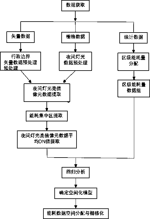
[0019] A spatialization method of urban energy consumption based on remote sensing night light data and energy consumption statistical data proposed by the present invention is described in detail in conjunction with the accompanying drawings and actual cases as follows:

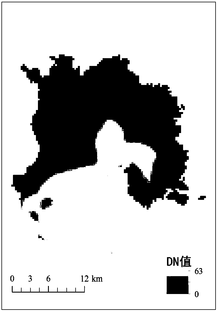
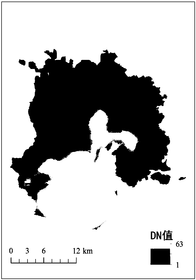
[0020] S1. The 2009 DMSP / OLS remote sensing image data comes from the National Geophysical Data Center of the United States. The data is a global night light image. The data pixel size is 30" arc, covering the longitude -180° to 180°, latitude -65 From ° to 75°, under the platform of remote sensing image processing software ENVI 5.4, the projection was converted to Gauss Kruger projection, and then resampled to 30m resolution by bilinear interpolation.

[0021] The use case of the present invention is the entire administrative area of ​​Xiamen City (excluding uninhabited small islands). Since the night light data obtained from the website of the National Geophysical Data Center of the National Oceanic and Atm...


PUM


Abstract

The invention provides an urban energy consumption spatialization method based on remote sensing night light data and energy consumption statistical data, and belongs to research in the fields of low-carbon cities, energy conservation and emission reduction. According to the method, DMSP / OLS remote sensing images and energy consumption statistical data are utilized at the same time, multiple formsof regression analysis are conducted on the average DN value of night light brightness value pixels and the energy consumption statistical data of an energy consumption concentration area, an energyconsumption spatial model is determined, and then grid-level urban energy consumption spatial distribution is simulated. According to the invention, distribution characteristics and rules of energy consumption in the administrative unit can be disclosed. Therefore, the spatial change rule of energy consumption can be analyzed more deeply, carefully and comprehensively, decision support is providedfor providing reasonable and effective energy conservation and emission reduction measures, and theoretical basis and practical guidance are provided for reasonable configuration of urban energy resources and sustainable development planning of low-carbon cities.

Description

technical field [0001] The invention belongs to the research field of low-carbon cities and energy saving and emission reduction, and in particular relates to a spatialization method of urban energy consumption based on remote sensing night light data and energy consumption statistical data. Background technique [0002] The low-carbon development path is the development trend of urban construction. Under the background of global resource shortage, energy shortage and climate warming, the development of low-carbon cities is an inevitable choice for my country to cope with climate change and achieve sustainable development. As the main carrier of industrial civilization and modern economic civilization, cities have huge energy consumption, which poses certain restrictions on regional development. The evaluation of urban energy consumption is one of the key links in energy conservation and emission reduction and the development of low-carbon cities. Only on the basis of finely...

Claims


Application Information

Patent Timeline
IPC IPC(8): G06Q10/06G06F17/18
Inventor 赵小锋王菲菲林剑艺
Owner INST OF URBAN ENVIRONMENT CHINESE ACAD OF SCI
Features
  • R&D
  • Intellectual Property
  • Life Sciences
  • Materials
  • Tech Scout
  • Unparalleled Data Quality
  • Higher Quality Content
  • 60% Fewer Hallucinations
Learn More