Geospatial modeling system providing non-linear in painting for voids in geospatial model frequency domain data and related methods

a geospatial model and frequency domain technology, applied in the field of topography, can solve the problems of not being well suited for 3d data models, voids left in the resulting dem, voids in cultural features when the foliage is present,

Inactive Publication Date: 2010-07-20
HARRIS CORP
View PDF17 Cites 29 Cited by
  • Summary
  • Abstract
  • Description
  • Claims
  • Application Information

AI Technical Summary

Benefits of technology

[0014]In view of the foregoing background, the present disclosure presents a geospatial modeling system and related methods which may advantageously fill voids within geospatial model data and related methods.

Problems solved by technology

Yet, once the cultural features are identified and extracted from the terrain data, there may be voids left in the resulting DEM.
Moreover, in some situations it may be desirable to focus on cultural features from an area of interest, but foliage, etc., may obscure portions of one or more cultural features that will similarly result in voids in the cultural feature when the foliage is extracted.
While this approach is well suited for communication and audio signals, it may not be well suited for 3D data models.
This approach is sometimes difficult to implement because the computational overhead may become overly burdensome for higher order polynomials, which may be necessary to provide desired accuracy.
While this approach may provide a relatively high reconstruction accuracy, this approach may be problematic to implement in a 3D data model because of the difficultly in solving a global spline over the entire model, and because the required matrices may be ill-conditioned.
One further drawback of such conventional techniques is that they tend to blur edge content, which may be a significant problem in a 3D topographical model.
However, due to interference from existing signal sources, during some SAR scans certain frequency bands may experience interference in the resulting SAR data.
Moreover, the operator of the SAR may have to intentionally omit or block certain frequency bands in certain geographical areas from the scan to avoid interfering with such communication sources.
Further, hardware malfunctions may result in pulse dropouts.
In each of these cases, the result is that the frequency domain representation of the area of interest will have gaps or voids therein, which when converted to the spatial domain cause the resulting geospatial model image to be distorted.

Method used


Image

  • Geospatial modeling system providing non-linear in painting for voids in geospatial model frequency domain data and related methods
  • Geospatial modeling system providing non-linear in painting for voids in geospatial model frequency domain data and related methods
  • Geospatial modeling system providing non-linear in painting for voids in geospatial model frequency domain data and related methods

Examples


Embodiment Construction

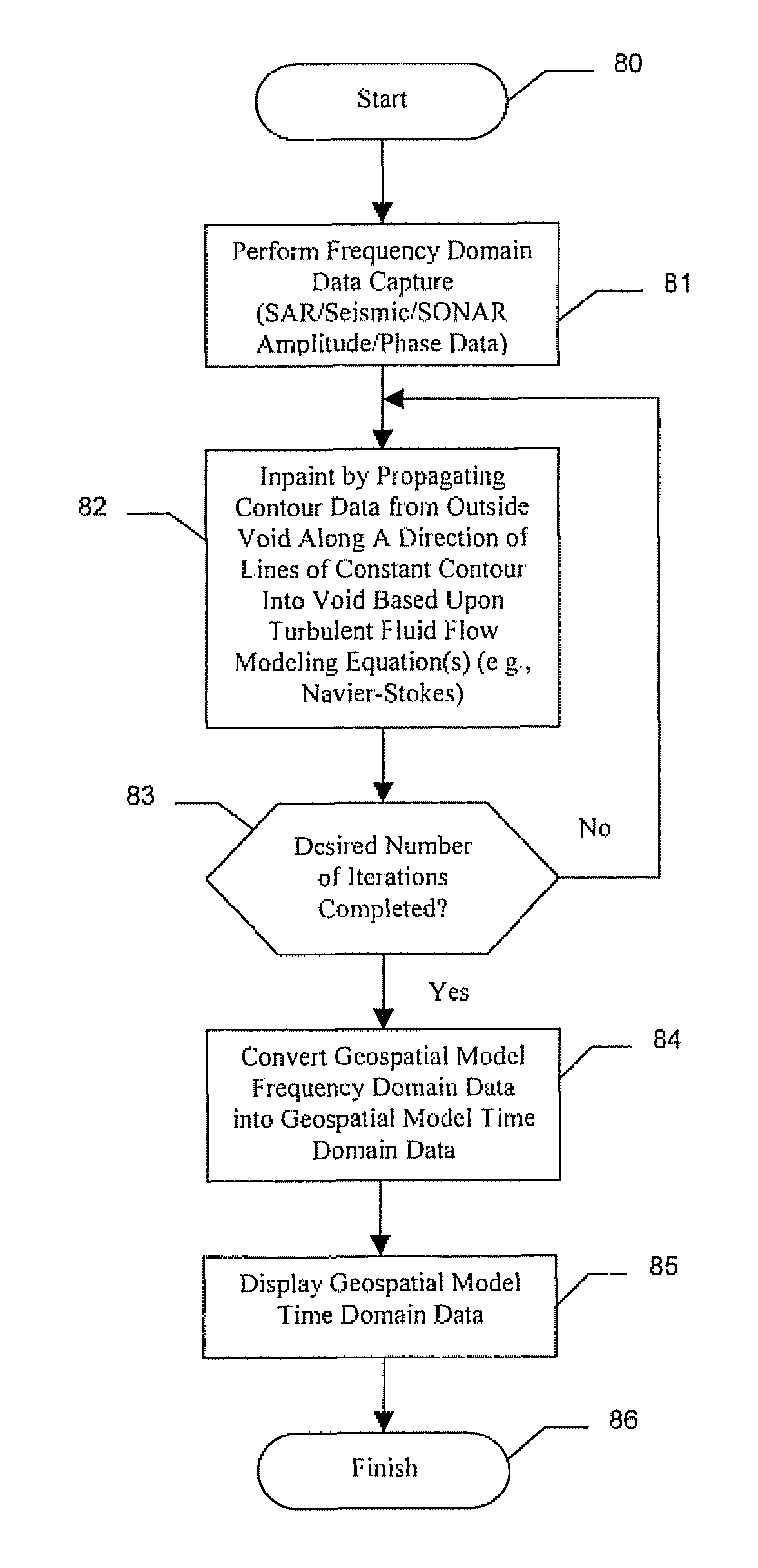
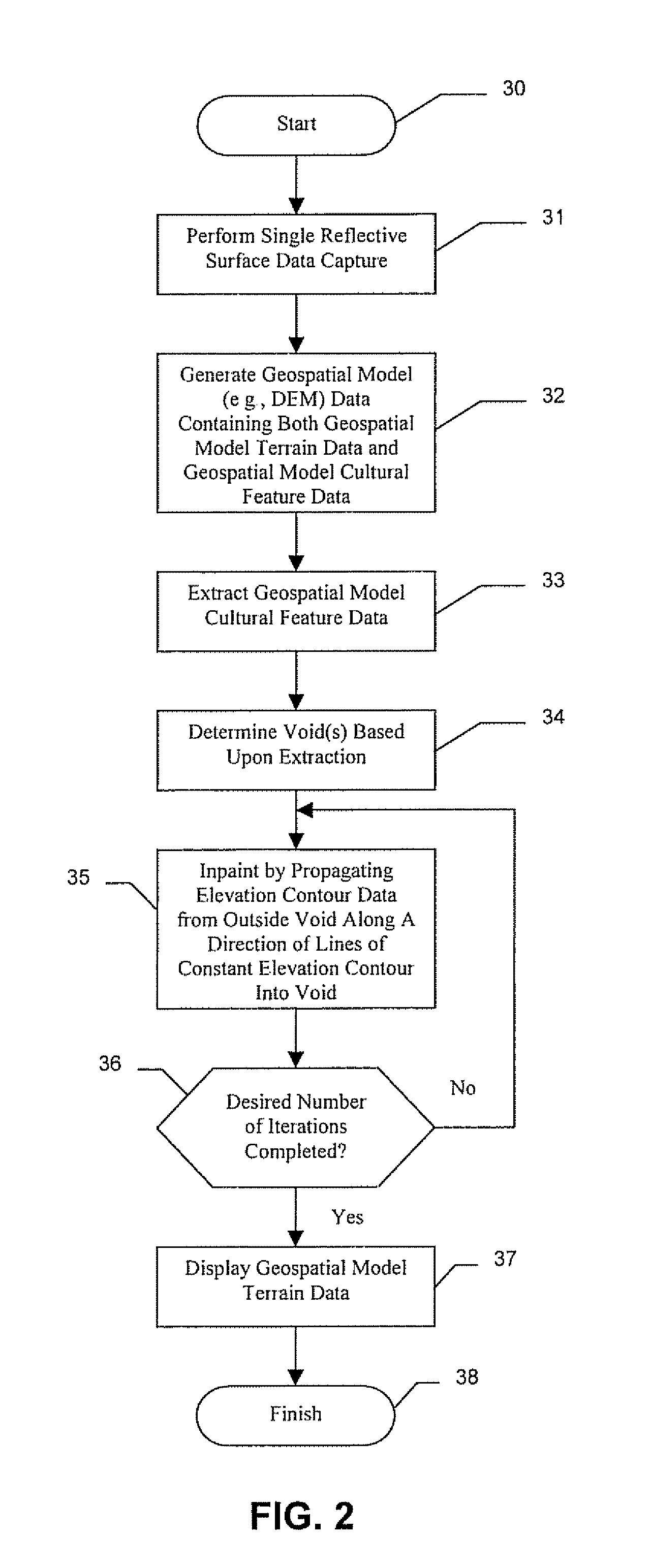
[0032]The present invention will now be described more fully hereinafter with reference to the accompanying drawings, in which preferred embodiments of the invention are shown. This invention may, however, be embodied in many different forms and should not be construed as limited to the embodiments set forth herein. Rather, these embodiments are provided so that this disclosure will be thorough and complete, and will fully convey the scope of the invention to those skilled in the art. Like numbers refer to like elements throughout, and prime and multiple prime notation are used to indicate similar elements in alternative embodiments.

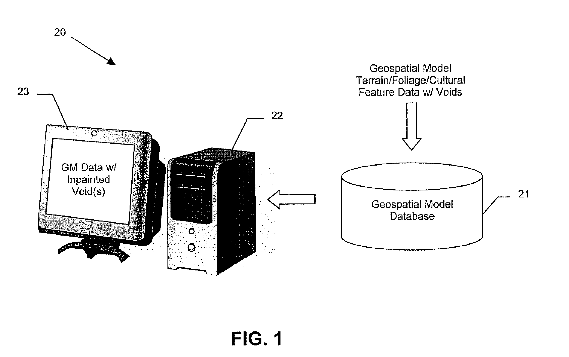
[0033]Referring initially to FIG. 1, a geospatial modeling system 20 illustratively includes a geospatial model database 21 and a processor 22, such as a central processing unit (CPU) of a PC, Mac, or other computing workstation, for example. A display 23 may be coupled to the processor 22 for displaying geospatial modeling data, as will be discussed fur...


PUM


Abstract

A geospatial modeling system may include a geospatial model database and a processor. More particularly, the processor may cooperate with the geospatial model database for inpainting data into at least one void in geospatial model frequency domain data based upon propagating contour data from outside the at least one void into the at least one void, and for converting the geospatial model frequency domain data after inpainting into geospatial model spatial domain data.

Description

FIELD OF THE INVENTION[0001]The present invention relates to the field of topography, and, more particularly, to a system and related methods for generating topographical models.BACKGROUND OF THE INVENTION[0002]Topographical models of geographical areas may be used for many applications. For example, topographical models may be used in flight simulators and for planning military missions. Furthermore, topographical models of man-made structures (e.g., cities) may be extremely helpful in applications such as cellular antenna placement, urban planning, disaster preparedness and analysis, and mapping, for example.[0003]Various types and methods for making topographical models are presently being used. One common topographical model is the digital elevation map (DEM). A DEM is a sampled matrix representation of a geographical area which may be generated in an automated fashion by a computer. In a DEM, coordinate points are made to correspond with a height value. DEMs are typically used ...

Claims


Application Information

Patent Timeline
Patent Type & Authority Patents(United States)
IPC IPC(8): G06K9/00G06T17/05
CPCG06T5/005G06T17/05
Inventor RAHMES, MARKSMITH, ANTHONY O'NEILALLEN, JOSEFPETER, ADRIAN M.GANTHIER, EMILEBEADLE, EDWARD
Owner HARRIS CORP
Why Eureka
Try Eureka