Method and device for determining position relation, equipment and storage medium
A technology for determining method and relationship, applied in the field of determination method and device, equipment and storage medium of position relationship, capable of solving the problems of high power consumption of GPS module, high power consumption, shortening battery life of mobile terminals, etc.
- Summary
- Abstract
- Description
- Claims
- Application Information
AI Technical Summary
Problems solved by technology
Method used
Image

Examples
Embodiment 1
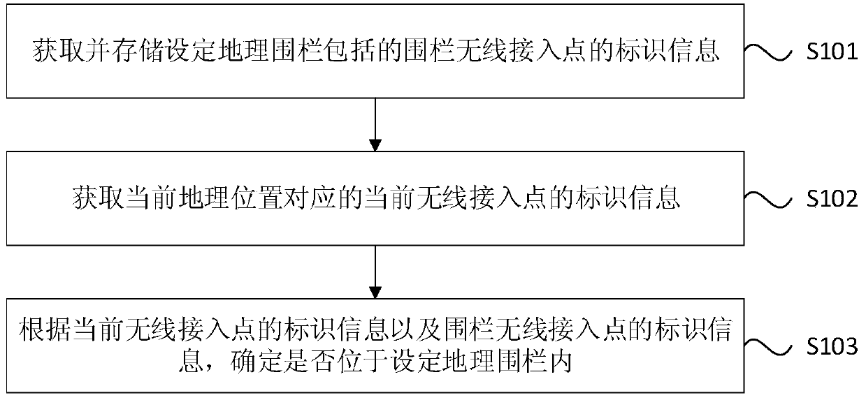
[0027] figure 1 It is a flow chart of the method for determining the positional relationship provided by Embodiment 1 of the present invention. The method can be executed by determining the positional relationship. The device can be implemented by software and / or hardware, and the device can be integrated in a server and other equipment. Such as figure 1 As shown, the method specifically includes the following steps:
[0028] S101. Acquire and store identification information of fenced wireless access points included in setting a geofence.
[0029] In this embodiment, the setting of the geo-fence may specifically be a user-defined geo-fence, or a geo-fence stored in the device for determining the positional relationship, which is not limited in this embodiment.
[0030] In this embodiment, the fenced wireless access point specifically refers to an access point of a wireless local area network located within a set geographic fence. Further, for the wireless access point loca...
Embodiment 2
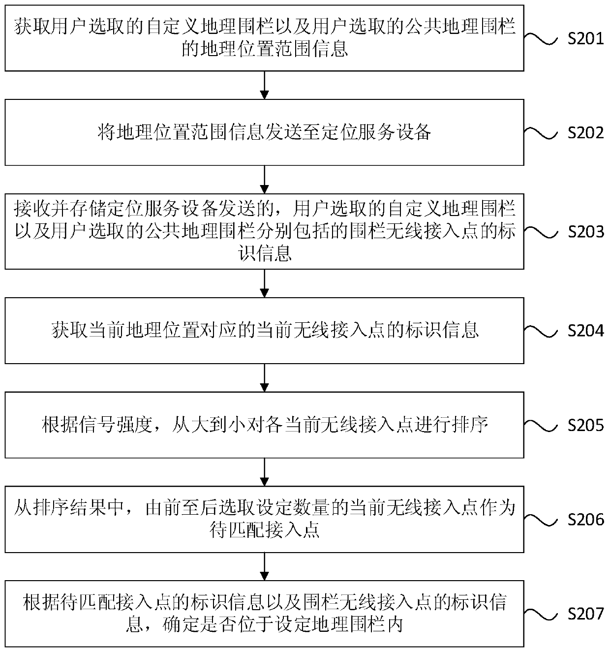
[0042] figure 2 It is a flow chart of a method for determining a positional relationship provided by Embodiment 2 of the present invention. This embodiment is optimized on the basis of the above embodiments. In this embodiment, a method for obtaining the identification information of the wireless access point of the specific fence is given, the geographical location range information of the specific geo-fence and the specific and The specific implementation manner of the method for determining the location relationship of the geographical fence is set. Explanations of terms that are the same as or corresponding to those in the above embodiment will not be repeated in this embodiment.
[0043] Correspondingly, the method in this embodiment specifically includes:
[0044]S201. Acquire the geographical location range information of the custom geo-fence selected by the user and the public geo-fence selected by the user.
[0045] In this embodiment, setting the geo-fence includ...
Embodiment 3
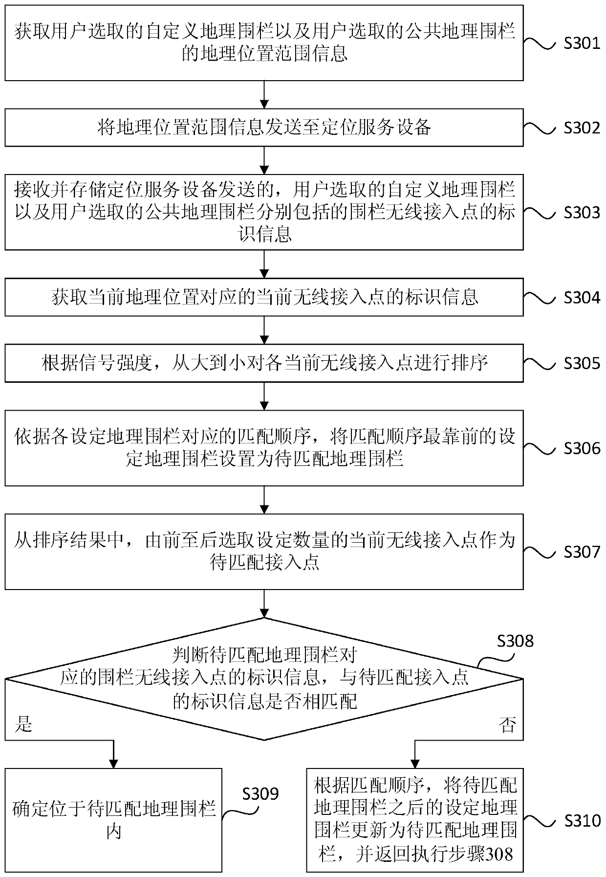
[0063] image 3 It is a flowchart of a method for determining a positional relationship provided by Embodiment 3 of the present invention. This embodiment is optimized on the basis of the above-mentioned embodiments. In this embodiment, a specific implementation of a method for determining the positional relationship between the embodiment and the setting of the geo-fence is provided. Explanations of terms that are the same as or corresponding to those in the above embodiment will not be repeated in this embodiment.
[0064] Correspondingly, the method in this embodiment specifically includes:
[0065] S301. Obtain the geographical location range information of the user-selected custom geo-fence and the user-selected public geo-fence.
[0066] S302. Send the geographic location range information to the positioning service device.
[0067] S303. Receive and store identification information of fence wireless access points included in the custom geo-fence selected by the user ...
PUM
 Abstract
Description
Claims
Application Information
 - R&D
- Intellectual Property
- Life Sciences
- Materials
- Tech Scout
- Unparalleled Data Quality
- Higher Quality Content
- 60% Fewer Hallucinations
Browse by: Latest US Patents, China's latest patents, Technical Efficacy Thesaurus, Application Domain, Technology Topic, Popular Technical Reports.
© 2025 PatSnap. All rights reserved.Legal|Privacy policy|Modern Slavery Act Transparency Statement|Sitemap|About US| Contact US: help@patsnap.com