
Integrated navigation information fusion method based on interactive multiple models

A technology of interactive multi-model and integrated navigation, which is applied in the field of multi-sensor data fusion of integrated navigation based on interactive multi-model, can solve the problems of error navigation accuracy, drop, and poor long-term stability, and achieve the goal of reducing error information and improving navigation accuracy Effect

Pending Publication Date: 2019-05-28
NANJING UNIV OF SCI & TECH
View PDF4 Cites 12 Cited by
  • Summary
  • Abstract
  • Description
  • Claims
  • Application Information

AI Technical Summary

Problems solved by technology

For example, the advantages of the inertial navigation system are: it does not require any external information and does not radiate any information, it can navigate in any medium and under any environmental conditions, and it can output various navigations such as the position, speed, orientation and attitude of the aircraft Parameters, the frequency bandwidth of the system, can track any maneuvering movement of the carrier, the navigation output data is stable, and the short-term stability is good, but the inertial navigation system has inherent shortcomings: the navigation accuracy diverges with time, that is, the long-term stability is poor
However, the integrated navigation system is essentially a multi-sensor data fusion system. As the number of sensors increases, the performance of the integrated navigation system can be effectively improved. However, as the number of sensors increases, it will also be difficult to select effective measurement information to update the model. The problem of weight coefficient, the resulting error information will reduce the navigation accuracy

Method used


Image

  • Integrated navigation information fusion method based on interactive multiple models
  • Integrated navigation information fusion method based on interactive multiple models
  • Integrated navigation information fusion method based on interactive multiple models

Examples


Embodiment 1

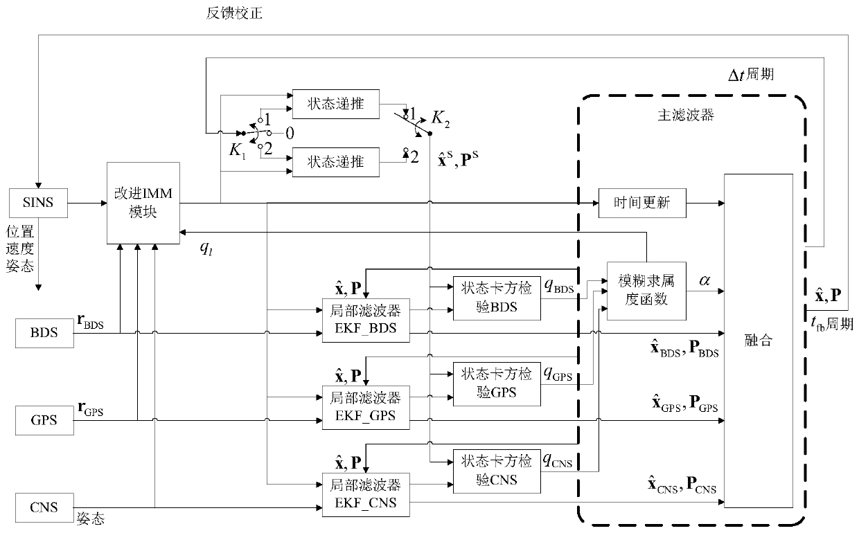
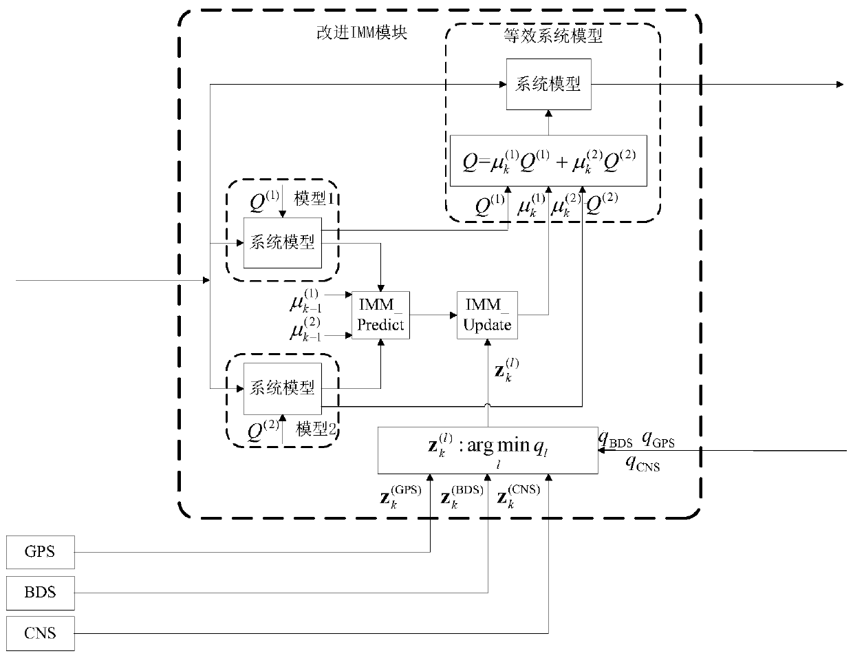
[0054] The basic structure of the present invention is as figure 1 As shown, the system model is constructed with SINS, and the characteristics of the inertial measurement unit are selected with an appropriate Q (1) and Q (2) As the two subsystem models of this method, the noise statistical characteristics are modeled, respectively, and the determined system model constitute the system sub-model M (1) and M (2) , run these two models independently, after two modules of interactive multi-model prediction and interactive multi-model update, the weight coefficient of the subsystem model at time k is obtained j=1, 2 represents the serial number of the corresponding subsystem model. Statistical Characteristics of Modeling Noise in Equivalent System Model denoted as Q (1) and Q (2) The weighted average sum of , the weighting coefficient at time k is given by Sure. will equivalently model noise statistics Constitute an equivalent system model with the determined system m...


PUM


Abstract

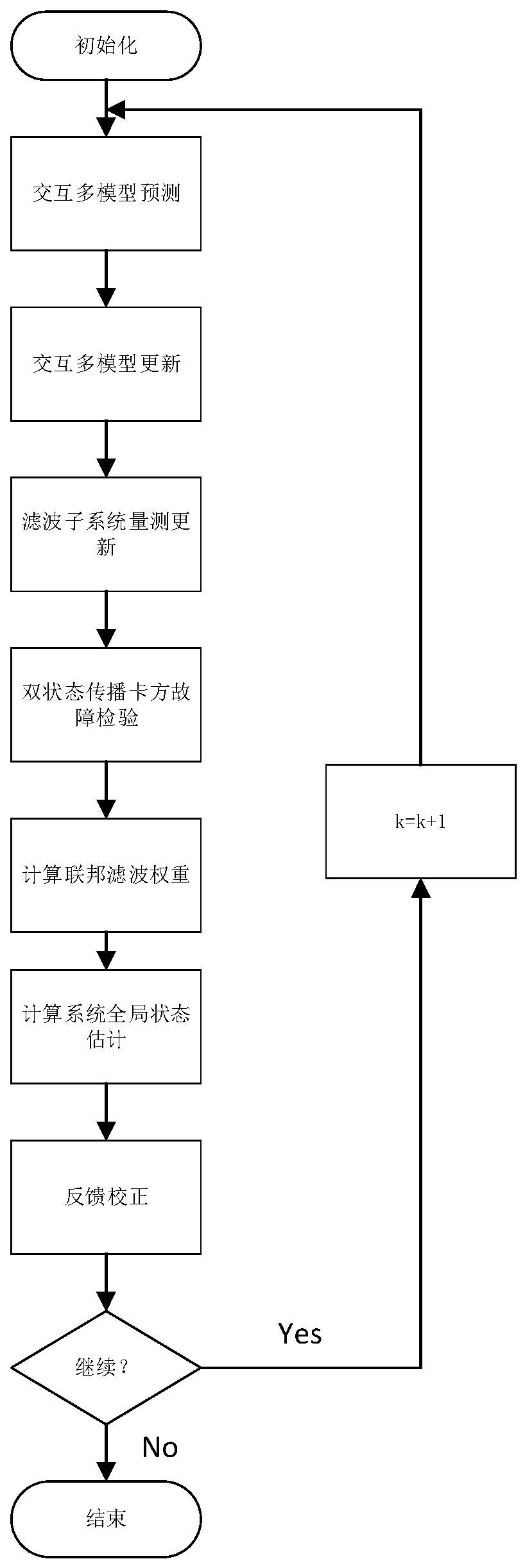
The invention discloses an integrated navigation information fusion method based on interactive multiple models. The method comprises the steps that firstly, a GPS measurement subsystem is selected for algorithm measurement update; then a measurement vector of the measurement subsystem with the minimum fault detection value is selected to upgrade the interactive multiple models, a subsystem modelweight coefficient is calculated, the statistical characteristics of modeling noise of an equivalent system are calculated, and an equivalent system model is formed; measurement update of filter subsystems is carried out, and the state estimation of each filter subsystem is calculated; then a two-state propagation chi-square fault testing method is utilized to perform fault detection on the measurement subsystem and calculate the federated filter weight; combined with the state estimation and federated filter weight of each filter subsystem, the global state estimation and a corresponding estimation error covariance matrix are calculated; finally, global state estimation feedback is taken as an initial value for the next iteration. The integrated navigation information fusion method basedon the interactive multiple models can effectively select navigation measurement information, and reduces the navigation error generated by information fusion of multiple sensors.

Description

technical field [0001] The invention relates to the technical field of combined navigation and multi-sensor information fusion, in particular to a multi-sensor data fusion method for combined navigation based on interactive multi-model. Background technique [0002] The development process of the navigation system, from the most primitive single navigation system, to the widely used INS / GPS integrated navigation system, to the current multi-sensor integrated navigation system based on INS / GNSS and assisted by other navigation systems, the research objectives are also From simply improving the accuracy of the navigation system, it has developed into a new generation of autonomous fault-tolerant and highly reliable integrated navigation system with the goal of comprehensively improving the accuracy, reliability and autonomy of the navigation system. [0003] The navigation system measures and calculates the instantaneous motion state and position of the vehicle, and provides i...

Claims


Application Information

Patent Timeline
IPC IPC(8): G01C21/00
Inventor 许曜鑫李胜杨春陈庆伟康晓柴培健
Owner NANJING UNIV OF SCI & TECH
Learn More