Open loop optimization method and system based on SLAM mapping

An optimization method and map technology, applied in the field of navigation, can solve the problems of cumulative errors that the robot cannot close the loop and the failure of map construction, etc., and achieve the effect of solving the problem of multi-map coordinate fusion, increasing robustness, and ensuring the coordinate system

Active Publication Date: 2019-05-28
SHANDONG UNIV
View PDF11 Cites 16 Cited by
  • Summary
  • Abstract
  • Description
  • Claims
  • Application Information

AI Technical Summary

Problems solved by technology

However, in the environment of giant loops and long corridors, if the cumulative ...

Method used


Image

  • Open loop optimization method and system based on SLAM mapping
  • Open loop optimization method and system based on SLAM mapping
  • Open loop optimization method and system based on SLAM mapping

Examples


Embodiment 4

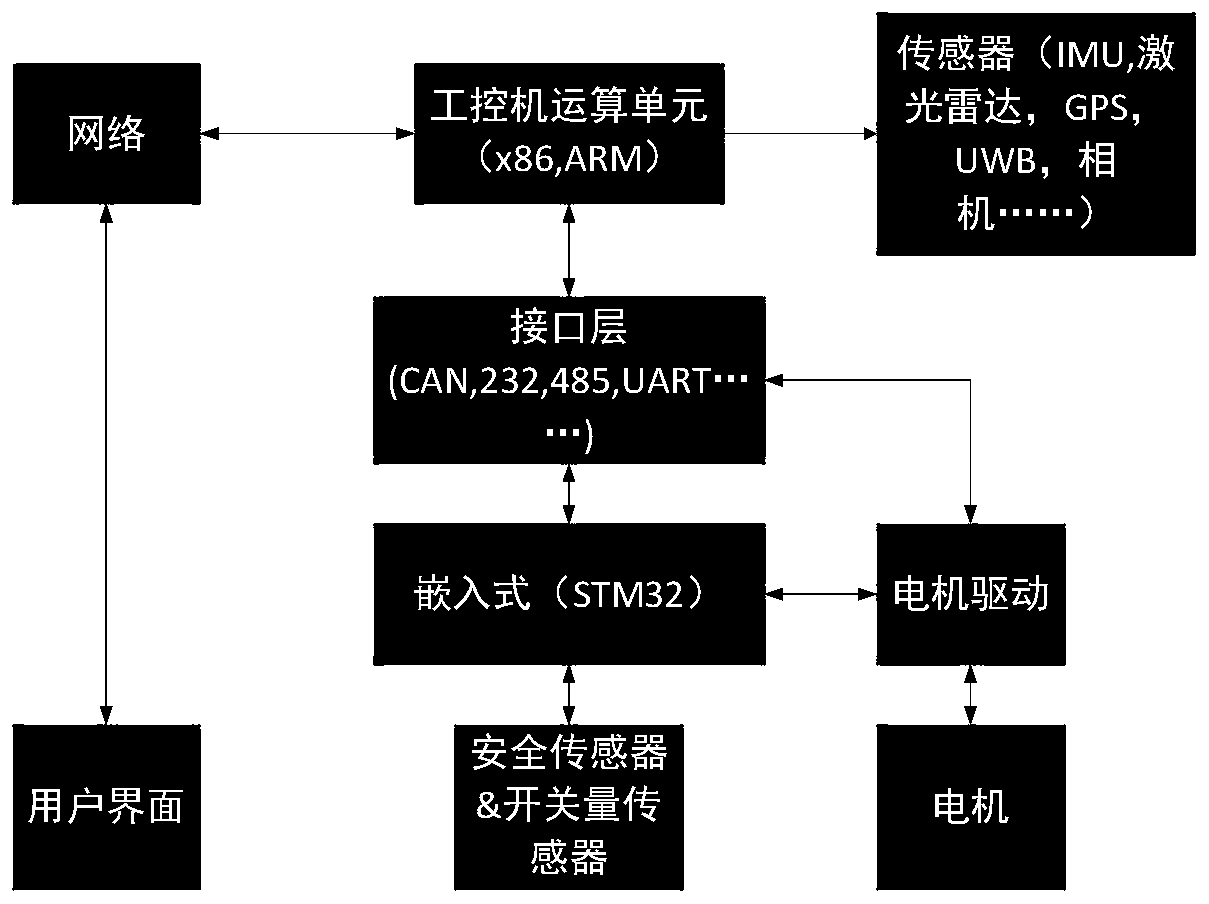
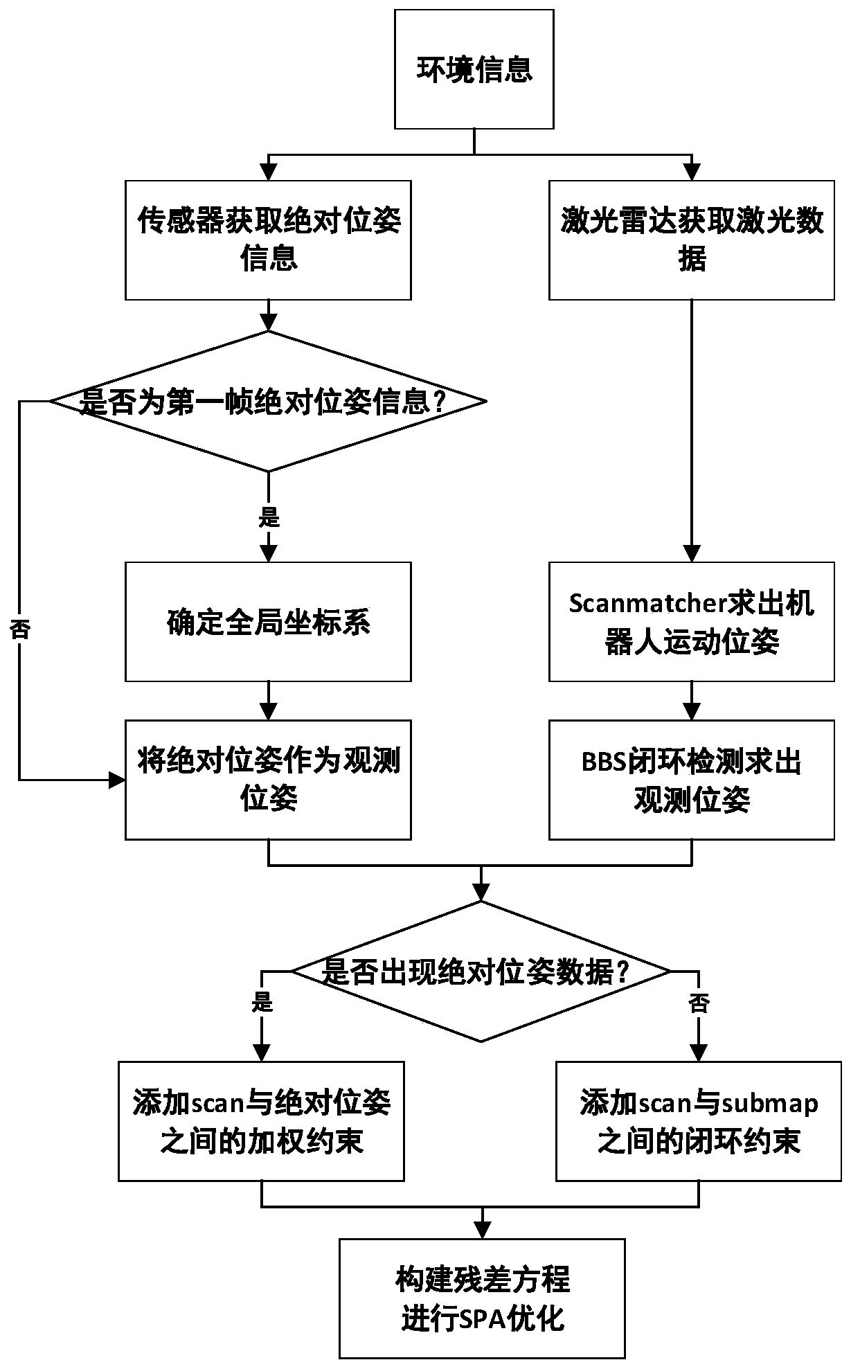
[0103] The embodiment of this specification provides a robot, the robot includes a robot body, the robot body is equipped with a laser radar sensor and a sensor for obtaining external absolute positioning information; the robot body can be a mechanical device of an ordinary robot.

[0104] Both the data detected by the lidar sensor and the external absolute positioning information are transmitted The computing processing unit can receive sensor information to construct and correct maps.

[0105] The local environment map information and absolute position information detected by the lidar, and the absolute position information received by the observation sensor are added to the time stamp information and then sent to the operation processing unit.

[0106] Since the absolute positioning information is not necessarily continuous, when the absolute positioning information is not received, the calculation processing unit only receives the local environmental map information of th...


PUM


Abstract

The invention provides an open loop optimization method and system based on SLAM mapping. The method comprises the steps that map information of a local environment where mapping needing equipment islocated is acquired, and mapping is carried out based on the map information of the local environment; in an open loop state, when the mapping needing equipment receives external absolute positioninginformation, constraints between the absolute positioning information and current movement position information are established, and according to constraint information, a global map is constructed. According to the technical scheme, the addition of the absolute positioning information is received through the open loop optimization, thereby ensuring the unification of a coordinate system, and being conductive to solving the problem of map fusion when a multi-robot collaboration map is constructed.

Description

technical field [0001] The invention relates to the technical field of navigation, in particular to an open-loop optimization method and system based on SLAM mapping. Background technique [0002] Simultaneous Localization and Mapping (SLAM) technology, that is, in a static unknown environment, learn the environmental map through the movement and measurement of the robot, and simultaneously determine the position of the robot on the map. [0003] In layman's terms, SLAM answers two questions: "Where am I?" Relative to the spatial relationship, "where am I" corresponds to the positioning problem, while "what is around me" corresponds to the mapping problem, giving a description of the surrounding environment. [0004] The SLAM problem was first proposed in an article written by Cheeseman and Smith in 1985, in which the statistical principles describing geometric uncertainty and the relationship between features and features were created. These principles constitute the mathe...

Claims


Application Information

Patent Timeline
IPC IPC(8): G01C21/20
Inventor 周风余于帮国万方边钧健庄文密
Owner SHANDONG UNIV
Why Eureka
Try Eureka