
Laser radar slanting route visibility retrieval method

A laser radar and visibility technology, applied in the field of laser radar atmospheric detection, can solve the problem of inaccurate measurement results of the visible distance of the slope during the day

Active Publication Date: 2019-05-31
XIAN UNIV OF TECH
View PDF26 Cites 8 Cited by
  • Summary
  • Abstract
  • Description
  • Claims
  • Application Information

AI Technical Summary

Problems solved by technology

[0005] The purpose of the present invention is to provide an inversion method of lidar slant visibility, which solves the problem of inaccurate daytime slant visible distance measurement results in the prior art

Method used


Image

  • Laser radar slanting route visibility retrieval method
  • Laser radar slanting route visibility retrieval method
  • Laser radar slanting route visibility retrieval method

Examples


Embodiment Construction

[0053] The present invention will be described in detail below in combination with specific embodiments.

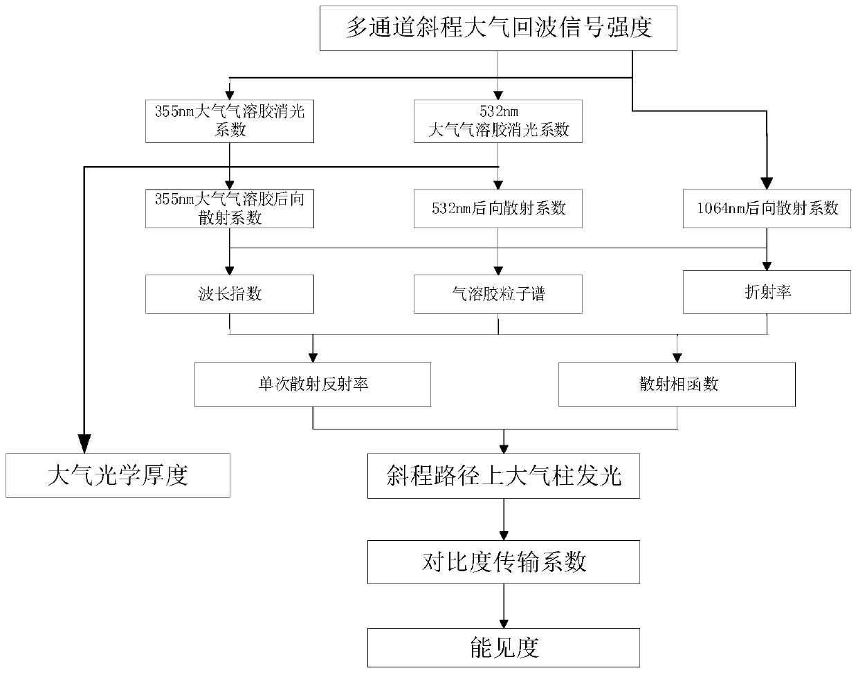
[0054] The present invention provides a method for inversion of lidar slant range visibility, such as figure 1 As shown, follow the steps below:

[0055] Step 1. Use lidar detection and inversion to obtain the optical profile of the atmospheric aerosol on the slope path at different wavelengths, the distribution of the backscattering coefficient profile of the atmospheric aerosol at height z, the distribution of the particle spectrum of the atmospheric aerosol and the atmospheric scattering profile of characteristics;

[0056] Step 1.1, use the Raman scattering echo signal intensity P1N(z) at the wavelength of 386nm to finely invert the atmospheric aerosol extinction coefficient profile αA(λ1,z) at the wavelength of 355nm, expressed as:

[0057]

[0058] Using the Raman scattering echo signal intensity P2N(z) at 607nm wavelength, the atmospheric aerosol extinction co...


PUM


Abstract

The invention discloses a laser radar slanting route visibility retrieval method. The method comprises the steps of: 1) employing laser radar detection inversion to obtain a profile of atmospheric aerosol optical parameters, microphysical parameters and atmospheric scattering characteristics on a slant path at different wavelengths to provide real-time and accurate atmospheric input parameters forthe solution of the atmospheric radiation transfer equation; 2) inputting the obtained atmospheric input parameters into the SBDART calculation software to obtain an atmospheric column illumination brightness on the slant path; 3) employing the atmospheric column illumination brightness on the slant path to establish a function relation of a contrast transmission coefficient and the slant opticalthickness; 4) determining the intrinsic contrast between the target and the background; and 5) employing the function relation of the contrast transmission coefficient and the slant optical thicknessand the intrinsic contrast between the target and the background, accurately solving the distribution of the visibility of the slanting path at different heights by employing a numerical method to determine the visibility value of the atmospheric slanting path. The problem is solved that the measurement result of the daytime slanting distance is inaccurate in the prior art.

Description

technical field [0001] The invention belongs to the technical field of laser radar atmospheric detection and the application technical field of space target detection, and relates to an inversion method of laser radar slope visibility. Background technique [0002] As an active remote sensing detection technology and tool that uses light waves as the excitation source and atmospheric molecules and aerosol particles as the medium, lidar has unique features in remote sensing detection height, spatial resolution, continuous monitoring in time, and measurement accuracy. 2) detection of atmospheric optical parameters; 3) detection of aerosol and plume; 4) detection of concentration and distribution of atmospheric gas components; 5) detection of atmospheric wind and detection of turbulence. [0003] Visibility forecasting plays an extremely important role in weather analysis, aviation and navigation, land transportation, astronomical observation and other fields. Visibility usua...

Claims


Application Information

Patent Timeline
IPC IPC(8): G01N21/17G01N21/65G01S17/88G01S17/95
CPCY02A90/10
Inventor 王玉峰李仕春闫庆刘晶晶狄慧鸽华灯鑫
Owner XIAN UNIV OF TECH
Learn More