A data conversion method, device and electronic equipment for vector data

A vector data and conversion method technology, applied in the GIS field, can solve problems such as low calculation efficiency, occupation, and large storage space

Active Publication Date: 2021-08-20
BEIJING DATUM TECH DEV +1
View PDF0 Cites 0 Cited by
  • Summary
  • Abstract
  • Description
  • Claims
  • Application Information

AI Technical Summary

Problems solved by technology

In the process of converting large-area vector data into raster data, in order to obtain higher calculation accuracy, it is necessary to set a higher resolution, which leads to low calculation efficiency of the system and takes up a large storage space

Method used


Image

  • A data conversion method, device and electronic equipment for vector data
  • A data conversion method, device and electronic equipment for vector data
  • A data conversion method, device and electronic equipment for vector data

Examples


Embodiment 1

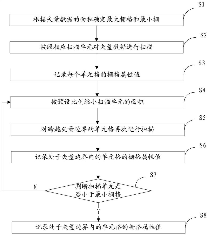
[0046] figure 1 It is a flowchart of a data conversion method for vector data according to an embodiment of the present application.

[0047] refer to figure 1 As shown, the data conversion method provided in this embodiment is used to convert vector data into corresponding raster data, and the raster data includes a plurality of cells, and each cell corresponds to a corresponding raster attribute value. The data conversion method comprises the steps of:

[0048] S1. Determine the maximum grid and the minimum grid according to the area of ​​the vector data.

[0049] The area here refers to the area of ​​the connected region in the vector data. In order to determine the grid on which the vector data is scanned, the area of ​​the connected region in the vector data is first calculated, and the maximum and minimum areas are found, that is, the maximum The area of ​​the connected region and the area of ​​the least connected region. In addition, for the convenience of calculati...

Embodiment 2

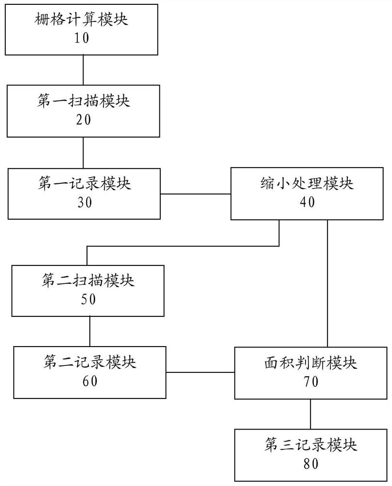
[0070] figure 2 It is a block diagram of a data conversion device for vector data according to an embodiment of the present application.

[0071] refer to figure 2 As shown, the data conversion device provided in this embodiment is used to convert vector data into corresponding raster data, and the raster data includes a plurality of cells, and each cell corresponds to a corresponding raster attribute value. The data conversion device includes a grid calculation module 10, a first scanning module 20, a first recording module 30, a reduction processing module 40, a second scanning module 50, a second recording module 60, an area judging module 70 and a third recording unit 80 .

[0072] The grid calculation module is used to determine the maximum grid and the minimum grid according to the area of ​​the vector data.

[0073] The area here refers to the area of ​​the connected region in the vector data. In order to determine the grid on which the vector data is scanned, the ...

Embodiment 3

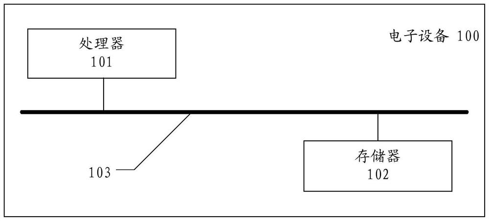
[0093] image 3 It is a block diagram of an electronic device according to an embodiment of the present application.

[0094] refer to image 3 As shown, the electronic device 100 provided in this embodiment can be specifically understood as an electronic computing device such as a mobile device, a data terminal, a personal computer, and a server, and at least includes a processor 101 and a memory 102 , which are connected through a data bus 103 . The memory is used to store computer programs or instructions, and the processor obtains and executes the computer programs or instructions through the data bus, so that the electronic device executes the data conversion method provided by this application, and the specific steps are:

[0095] Calculate the maximum area and the minimum area of ​​the vector data to be converted, determine the maximum grid according to the maximum area, determine the minimum grid according to the minimum area, and use the maximum grid as the scanning un...


PUM


Abstract

The application provides a data conversion method, device and electronic equipment for vector data, specifically determining the maximum grid and the minimum grid according to the maximum area and minimum area of ​​the vector data; scanning the vector data according to the maximum grid for the first time, and obtaining Multiple cells; record the value of the cell within the vector boundary of the vector data as the raster attribute value of the vector data; sequentially reduce the area of ​​the scanning unit; according to the reduced scanning unit, the cells crossing the vector boundary are again Scan to obtain multiple cells; record the value of the cell within the vector boundary as the raster attribute value of the vector data; and so on. By gradually reducing the scanning unit, this scheme can convert larger connected areas with larger grids to improve computational efficiency, and convert smaller connected areas with smaller grids to ensure conversion accuracy, so as to achieve In the case of guaranteeing accuracy, high computational efficiency is achieved.

Description

technical field [0001] The invention relates to the technical field of GIS, in particular to a data conversion method, device and electronic equipment for vector data. Background technique [0002] In GIS applications, many calculations are usually performed under the raster data structure, such as soil erosion calculations in the soil and water conservation industry. It is usually necessary to convert vector data, such as surface layers, into raster data, so that the calculation of raster data to get the final result. In the process of converting large-area vector data into raster data, in order to obtain higher calculation accuracy, it is necessary to set a higher resolution, which leads to low calculation efficiency of the system and takes up a large storage space. Contents of the invention [0003] In view of this, the present invention provides a data conversion method, device and electronic equipment for vector data, so as to solve the problem of improving calculati...

Claims


Application Information

Patent Timeline
Patent Type & Authority Patents(China)
IPC IPC(8): G06F16/29G06F16/22G06F16/25
Inventor 常丹东杜学才李春潮毕发江李振兴郭雪平施明郭浩许永利李团宏
Owner BEIJING DATUM TECH DEV
Why Eureka
Try Eureka