A coastline remote sensing calculation method for self-adaptive fitting of a profile form

A coastline and self-adaptive technology, applied in the field of marine remote sensing information technology and application, can solve the problems of high contingency and inadaptability to profile shape changes, etc., and achieve the effect of improving fit, position accuracy and applicability

Active Publication Date: 2019-06-21
NANJING NORMAL UNIVERSITY
View PDF4 Cites 11 Cited by
  • Summary
  • Abstract
  • Description
  • Claims
  • Application Information

AI Technical Summary

Problems solved by technology

[0005] Aiming at the problems in the current coastline remote sensing calculation methods, the general high tide line method has high contingency and the average slope method is not suitable for areas with large profile shape changes. The present invention proposes a coastline remote sensing calculation method for profile shape adaptive fitting. Simulate the scouring and silting morphology characteristics of the coastline, improve the fit between the shoreline position simulation and the shoreline profile shape, and improve the accuracy of the coastline position calculated by remote sensing

Method used


Image

  • A coastline remote sensing calculation method for self-adaptive fitting of a profile form
  • A coastline remote sensing calculation method for self-adaptive fitting of a profile form
  • A coastline remote sensing calculation method for self-adaptive fitting of a profile form

Examples


Embodiment Construction

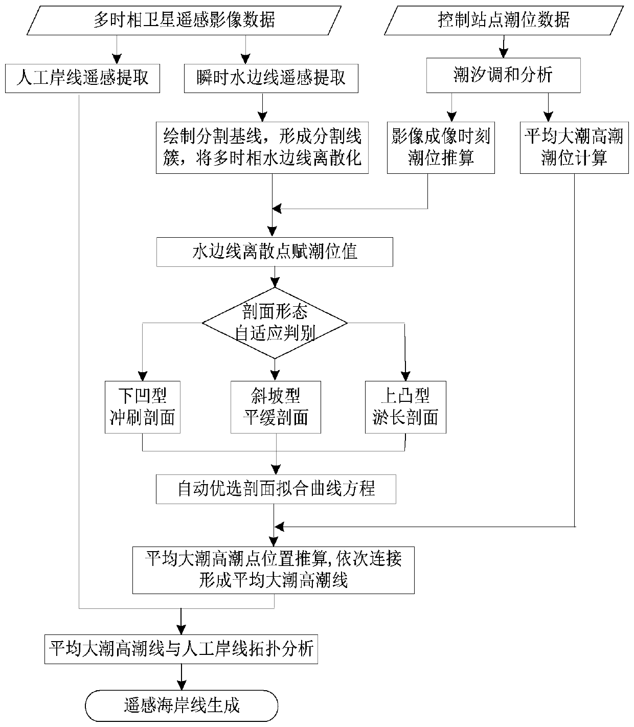
[0071] Below in conjunction with accompanying drawing, technical scheme of the present invention will be further described:

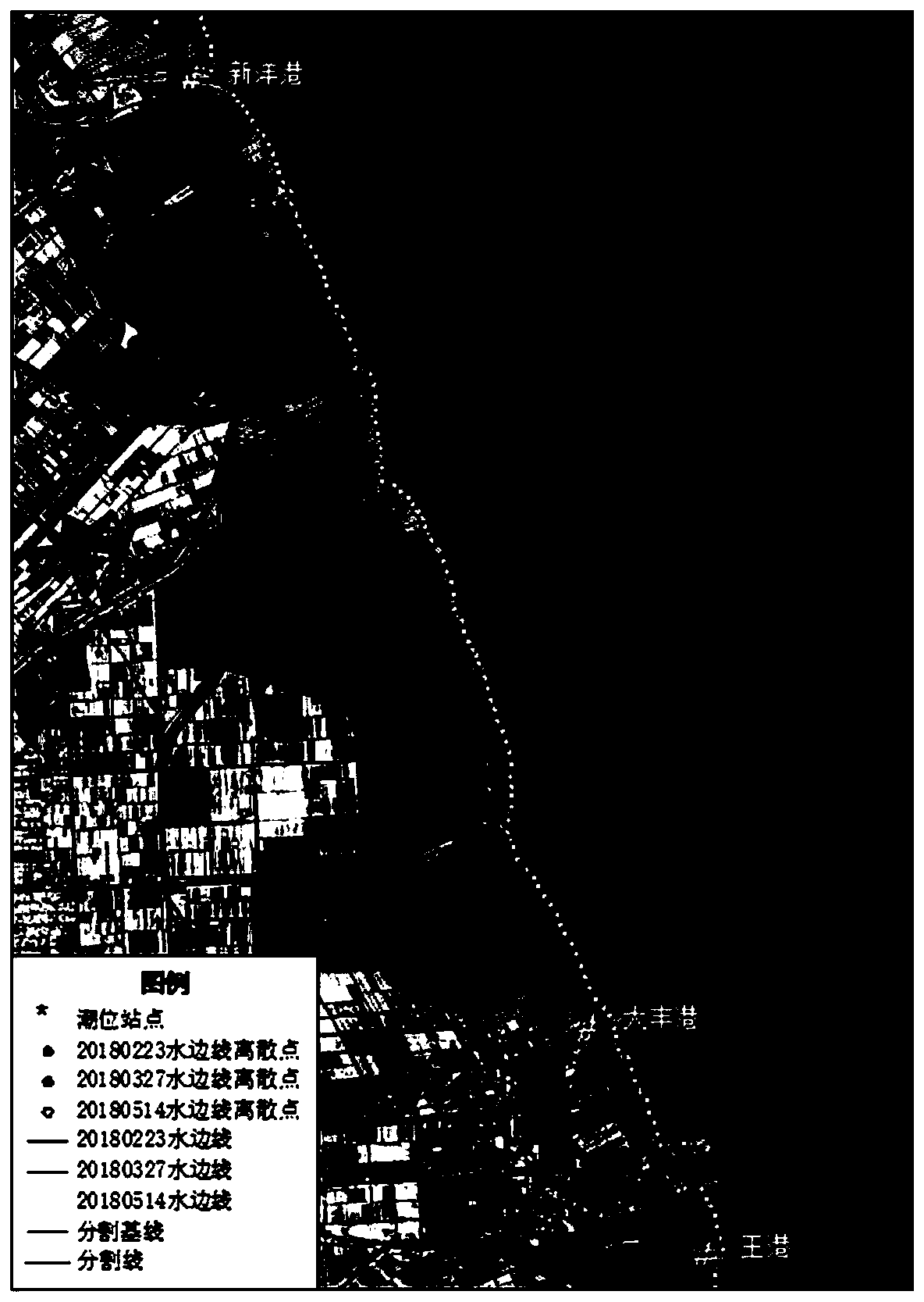
[0072] In this specific embodiment, the multi-temporal Landsat8 OLI satellite images covering the central coast of Jiangsu Province in 2018 are selected as the remote sensing data source. The tide level data comes from three tide level control stations of Xinyanggang, Dafenggang, and Wanggang, and Envi5.1 is used as the remote sensing data source. Image processing tools, ArcGIS10.2 as a vector data processing tool, Origin9.1 as a profile curve batch fitting tool.

[0073] A coastline remote sensing method for self-adaptive fitting of section shape, such as figure 1 As shown, it specifically includes the following steps:

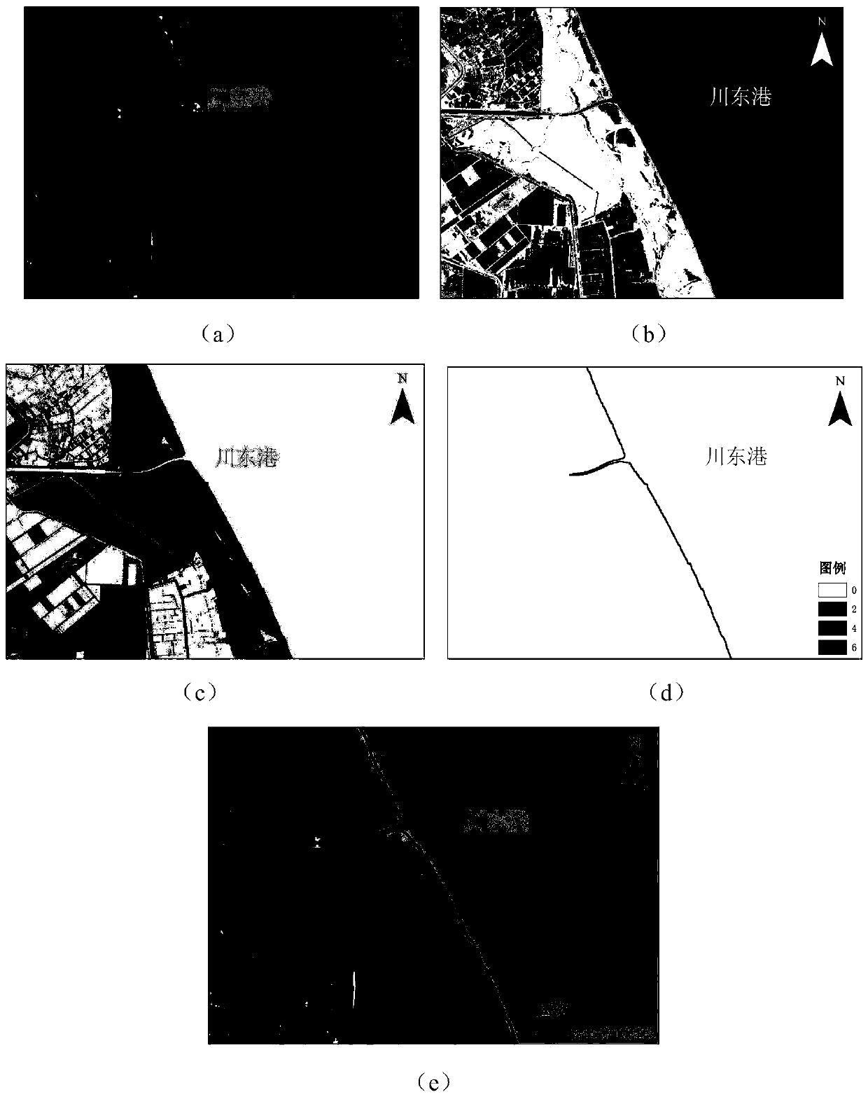
[0074] S1. Cut out the coastal areas on both sides of the Eastern Chuandong Port in the original image of Landsat8 OLI satellite on February 23, 2018 as the original image of the coastline remote sensing image, as shown in figure 2 ...


PUM


Abstract

The invention provides a coastline remote sensing calculation method for self-adaptive fitting of a profile form. The coastline remote sensing calculation method comprises the following steps: S1, extracting an instantaneous water side line and an artificial coastline from a coastline multi-temporal satellite remote sensing image; S2, segmenting and discretizing the water side line to obtain a water side line discrete point sequence of each profile; S3, completing tide level assignment of each profile water side line discrete point sequence; S4, judging the shape characteristics of the section, and determining the type of the section; S5, performing profile form fitting to obtain a form fitting equation of the profile; S6, calculating the position of an average heavy tide point of the section by utilizing a section shape fitting equation, and sequentially connecting the average heavy tide point along the direction of the coast to form an average heavy tide line; And S7, processing theaverage heavy tide and high tide line and the artificial shoreline by utilizing a spatial topological analysis method to obtain a remote sensing calculation shoreline. The method breaks through the assumption that the bank slope is single, and compared with a traditional method, the method has better applicability and higher accuracy.

Description

technical field [0001] The invention relates to a coastline remote sensing calculation method, which belongs to the field of marine remote sensing information technology and application technology. Background technique [0002] The coastline is the dividing line between the sea and the land, and the accurate determination of the coastline is of great significance to the use and management of coastal space resources. Traditional coastline measurement methods include field survey and photogrammetry. Although these methods can generate coastlines with high accuracy, they are time-consuming, labor-intensive and time-sensitive, and are not easy to monitor and apply in large-scale coastal areas. Since the beginning of the 21st century, the emergence and extensive use of multi-source, multi-resolution, and multi-temporal remote sensing images have greatly improved the accuracy, accuracy, and timeliness of coastal zone information extraction. new technical means. [0003] There ar...

Claims


Application Information

Patent Timeline
Patent Type & Authority Applications(China)
IPC IPC(8): G06K9/00G06K9/34G06K9/46
CPCY02A10/40
Inventor 张东沙宏杰周永
Owner NANJING NORMAL UNIVERSITY
Why Eureka
Try Eureka