Spaceborne imaging data management method based on multi-level file symbols

A file symbol, imaging data technology, applied in file system management, file system, file/folder operation, etc., can solve the problems of inability to adapt to satellite diverse imaging capabilities, inability to adapt to multi-level file symbols, and cumbersome manipulation, etc. To achieve the effect of reliable expansion capability, orderly classification, and flexible control

Active Publication Date: 2021-08-27
SHANGHAI SATELLITE ENG INST
View PDF16 Cites 0 Cited by
  • Summary
  • Abstract
  • Description
  • Claims
  • Application Information

AI Technical Summary

Problems solved by technology

However, this application cannot adapt to multi-level file symbols, and the manipulation is relatively cumbersome, and it cannot adapt to the diverse imaging capabilities of satellites.

Method used


Image

  • Spaceborne imaging data management method based on multi-level file symbols

Examples


Embodiment

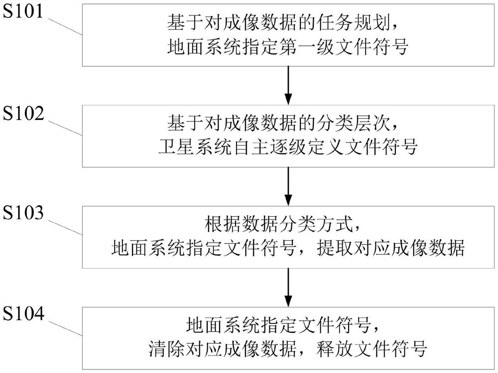
[0032] In this embodiment, a method for managing spaceborne imaging data based on multi-level file symbols of the present invention includes the following steps:

[0033] Step 1. Based on the task planning of the imaging data, according to a task corresponding to a first-level file symbol, the ground system specifies the first-level file symbol;

[0034] Step 2. Based on the classification level of the imaging data, one classification corresponds to a first-level file symbol, and one type of content corresponds to a same-level file symbol, and the satellite system independently defines the file symbol level by level;

[0035] Step 3. When the satellite is directional and returned, according to the data classification method, the ground system specifies the file symbol and extracts the corresponding imaging data;

[0036] Step 4: After the information is used, the ground system specifies the file symbol, clears the corresponding imaging data, and releases the file symbol.

[0...


PUM


Abstract

The present invention relates to a spaceborne imaging data management method based on a multi-level file symbol in the field of spaceborne imaging data management technology, comprising the following steps: Step 1. Based on the task planning of the imaging data, the ground system specifies the first-level file symbol; Step 2: Based on the classification level of the imaging data, the satellite system independently defines the file symbol level by level; Step 3: According to the data classification method, the ground system specifies the file symbol and extracts the corresponding imaging data; Step 4: The ground system specifies the file symbol and clears the corresponding Imaging data, release file symbol. The present invention is applicable to the field of space-borne imaging data management, solves the problem of disordered data classification in the space-borne imaging data management method, improves the efficiency of on-board task execution, enhances the flexibility of ground manipulation, and can adapt to the diverse imaging capabilities of satellites .

Description

technical field [0001] The invention relates to the technical field of spaceborne imaging data management, in particular to a method for managing spaceborne imaging data based on multi-level file symbols. Background technique [0002] The spaceborne imaging data management method refers to remote sensing satellites using certain parameters as the control object, and according to certain association rules, the imaging data is classified, stored, transferred, extracted, and cleared, and it also includes the method of ground system control satellites. [0003] With the intelligent development of remote sensing satellite imaging technology, identification technology and control technology, satellite imaging has higher precision, more times, and wider range. In the task, the comprehensive ability of performing fixed-point identification and imaging autonomously after implementing wide-area search imaging, the satellite imaging process is more targeted at the target area, the data...

Claims


Application Information

Patent Timeline
Patent Type & Authority Patents(China)
IPC IPC(8): G06F16/11G06F16/16
Inventor 于广洋朱少杰姜岩撒文彬崔华黄欣王伟杰童庆为
Owner SHANGHAI SATELLITE ENG INST
Why Eureka
Try Eureka