A backpack type three-dimensional laser point cloud data-based building contour line extraction method

A point cloud data and three-dimensional laser technology, applied in the field of geographic information, can solve the problems of low work efficiency and automation, achieve high-precision automatic extraction, complete acquired data, and high work efficiency

Active Publication Date: 2019-06-28
SUZHOU IND PARK SURVEYING MAPPING & GEOINFORMATION CO LTD
View PDF7 Cites 19 Cited by
  • Summary
  • Abstract
  • Description
  • Claims
  • Application Information

AI Technical Summary

Problems solved by technology

[0005] In order to improve the problem of low work efficiency and automation in the process of measuring building outlines by means of wire surveying and triangulation in the existing surveying and mapping industry, the present invention proposes a method based on point cloud data of a backpack-type 3D laser scanning system to realize building outlines. The high-precision automatic extraction method of lines adopts the following technical solutions:

Method used


Image

  • A backpack type three-dimensional laser point cloud data-based building contour line extraction method
  • A backpack type three-dimensional laser point cloud data-based building contour line extraction method
  • A backpack type three-dimensional laser point cloud data-based building contour line extraction method

Examples


Embodiment Construction

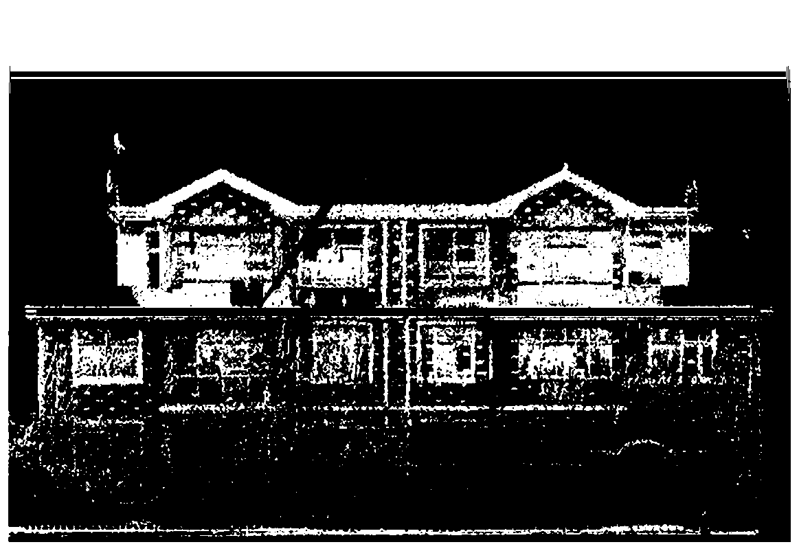
[0045]In this embodiment, a community is taken as the research object, and the Leica Pegasus mobile real scene measurement backpack is used to collect data in the community, obtain point cloud data and photos of the target building, and then use hardware supporting IE software to perform GNSS format conversion, trajectory calculation and Pre-check, then use the supporting Infinity software to establish a coordinate system, and finally use the supporting AutoP software to perform SLAM calculation (modify the trajectory) and export point cloud data in LAS format.

[0046] At first select an independent building to carry out contour line extraction to set forth the processing procedure of the proposed method of the present invention, figure 2 For the individual building data and slice locations:

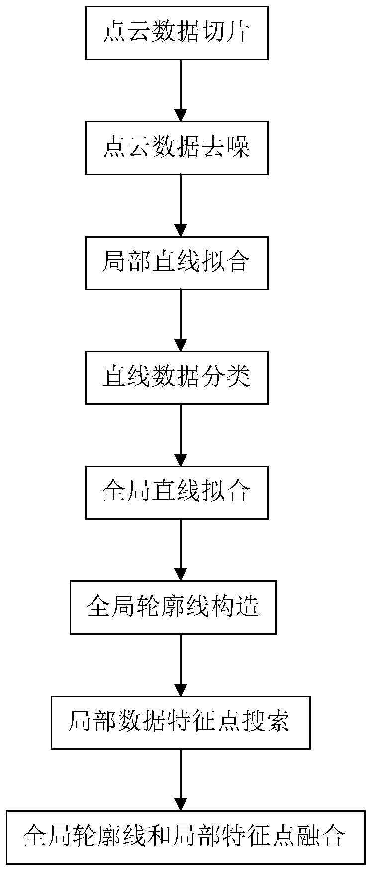
[0047] A method for automatically extracting building outlines based on backpack-type three-dimensional laser point cloud data, comprising the following steps:

[0048] S1. Point clou...


PUM


Abstract

The invention provides a building contour line automatic extraction method based on backpack type three-dimensional laser point cloud data. The method specifically comprises the following steps that 1, realizing point cloud data slicing, point cloud data denoising, local straight line fitting, linear data classification, overall straight line fitting, overall contour line configuration, local datafeature point searching and overall contour line and local feature point fusing. According to the method, a backpack three-dimensional laser scanning system is adopted, so that data can be acquired at a place where people can pass through the backpack three-dimensional laser scanning system, the operation mode is more flexible, the acquired data are more complete, the working efficiency is higher, and the cost is lower; point cloud data is subjected to neighborhood searching, a principal component analysis method and a fuzzy C-means algorithm point by point through a kd tree, and high-precision automatic extraction of the building contour is achieved; accurately fitting the slope of a local straight line by using the unit feature vector; and accurate classification of straight line data with different slopes can be realized through clustering based on the included angle data of the fitting straight line and the X axis.

Description

technical field [0001] The invention relates to the technical field of geographic information, in particular to a building outline extraction method based on backpack-type three-dimensional laser point cloud data. Background technique [0002] With the gradual deepening of concepts such as "digital city", urban spatial information has become an indispensable and important resource in today's society. As the most important part of the city, buildings and their outlines are realized based on remote sensing data. High-precision and fast extraction will provide important basic data for "digital cities", and it is also one of the difficulties in the current research field. [0003] The methods used in surveying and mapping industry to measure the outline of buildings mainly include traverse survey, triangulation, etc. During the measurement process, it is necessary to lay out control points and measure the feature points of the outline point by point, and then use drawing softwar...

Claims


Application Information

Patent Timeline
Patent Type & Authority Applications(China)
IPC IPC(8): G06T7/13G06K9/62
Inventor 邢万里蔡东健周旺辉岳顺
Owner SUZHOU IND PARK SURVEYING MAPPING & GEOINFORMATION CO LTD
Why Eureka
Try Eureka