Low-orbit satellite real-time orbital determination method

A low-orbit satellite and orbit determination technology, applied to satellite radio beacon positioning systems, measuring devices, instruments, etc., can solve problems such as unsatisfactory positioning accuracy, increased state vector dimensions, and high difficulty

Inactive Publication Date: 2019-07-09
SHANGHAI SATELLITE ENG INST
View PDF4 Cites 20 Cited by
  • Summary
  • Abstract
  • Description
  • Claims
  • Application Information

AI Technical Summary

Problems solved by technology

But they all have their own shortcomings: the positioning accuracy of method 1 is not ideal; method 2 involves the resolution o

Method used


Image

  • Low-orbit satellite real-time orbital determination method
  • Low-orbit satellite real-time orbital determination method
  • Low-orbit satellite real-time orbital determination method

Examples


Embodiment Construction

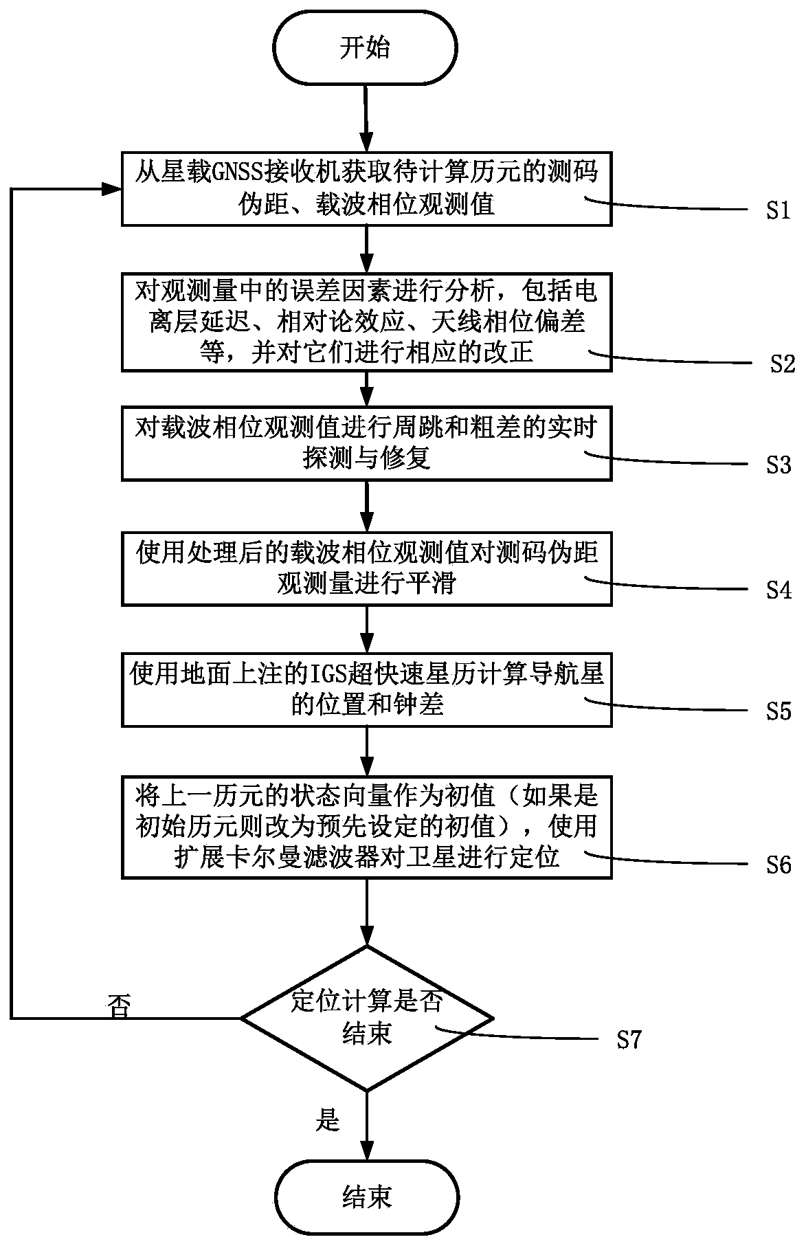
[0032] The present invention will be described in detail below in conjunction with specific embodiments. The following examples will help those skilled in the art to further understand the present invention, but do not limit the present invention in any form. It should be noted that those skilled in the art can make several changes and improvements without departing from the concept of the present invention. These all belong to the protection scope of the present invention.

[0033] Such as figure 1 Shown, a kind of LEO satellite real-time orbit determination method, it comprises the following steps:

[0034] Step S1: Obtain the dual-frequency code measurement pseudo-range and carrier phase observations of the epoch to be positioned from the spaceborne GNSS receiver;

[0035] Step S2: Perform error correction on the obtained dual-frequency code measurement pseudo-range and carrier phase observations, including: ionospheric delay, relativistic effect, antenna phase center er...


PUM


Abstract

The invention discloses a low-orbit satellite real-time orbital determination method. The method comprises the following steps: acquiring double-frequency code measurement pseudo-range and carrier phase observed quantity of a to-be-positioned epoch from a satellite-borne GNSS receiver; performing error correction on the acquired double-frequency code measurement pseudo-range and carrier phase observed quantity, wherein the error correction comprises ionized layer delay, relativity theory effect, antenna phase center error, and earth rotation effect; performing cycle-slip and gross error real-time detection and restoration on the carrier phase observed quantity after error correction; performing smoothing on the code measurement pseudo-range observed quantity by using processed carrier phase observed value; computing location and clock difference information of a navigation satellite by using an IGS ultra-fast ephemeris marked on the ground; taking a positioning result of the previous epoch as initial value, and computing a low-orbit satellite positioning result of the current epoch by using an extended Kalman filter; judging whether the positioning task is ended or not; and returning to the first step to continuously compute if the positioning task is not ended. The method disclosed by the invention can achieve high positioning precision in adaptive to the on-board processor finite computing resources.

Description

technical field [0001] The invention relates to real-time positioning technology, and more specifically, relates to a method for real-time orbit determination of low-orbit satellites. Background technique [0002] At present, fields such as high-precision surveying and mapping and navigation enhancement require high-precision positioning data from low-orbit satellites. With the continuous expansion of demand, more and more applications have put forward requirements for real-time and high-precision positioning. At present, most of the researches conducted by scholars at home and abroad are using the following two methods: method one is to use code measurement pseudo-range or side-phase distance as the observation quantity, use broadcast ephemeris to calculate the position and clock error of the navigation star, and then combine the simplified dynamic Mathematical equations, using the extended Kalman filter for calculation; Method 2 is generally the same as Method 1 except tha...

Claims


Application Information

Patent Timeline
IPC IPC(8): G01S19/42G01S19/30G01S19/27
CPCG01S19/27G01S19/30G01S19/42
Inventor 郑永艾张伟章英杰梁尔涛施伟璜
Owner SHANGHAI SATELLITE ENG INST
Why Eureka
Try Eureka