lidar data 'cloud-controlled' aerial photogrammetry method

An aerial image and photogrammetry technology, applied in the field of LiDAR data "cloud control" aerial image photogrammetry, high-precision geometric registration of image and LiDAR point cloud, can solve the problem of relying on field control points and 3D geographic information automation level Advanced problems, achieve the effect of getting rid of dependence, improving plane accuracy and elevation accuracy, and improving processing efficiency

Active Publication Date: 2020-04-24
WUHAN UNIV
View PDF5 Cites 2 Cited by
  • Summary
  • Abstract
  • Description
  • Claims
  • Application Information

AI Technical Summary

Problems solved by technology

[0006] The invention mainly solves the problem that the prior art obtains the high-precision three-dimensional geographic information of the measuring area with a low automation level and strongly relies on field control points

Method used


Image

  • lidar data 'cloud-controlled' aerial photogrammetry method
  • lidar data 'cloud-controlled' aerial photogrammetry method
  • lidar data 'cloud-controlled' aerial photogrammetry method

Examples


Embodiment Construction

[0034] The technical solutions of the present invention will be further specifically described below through the embodiments and in conjunction with the accompanying drawings.

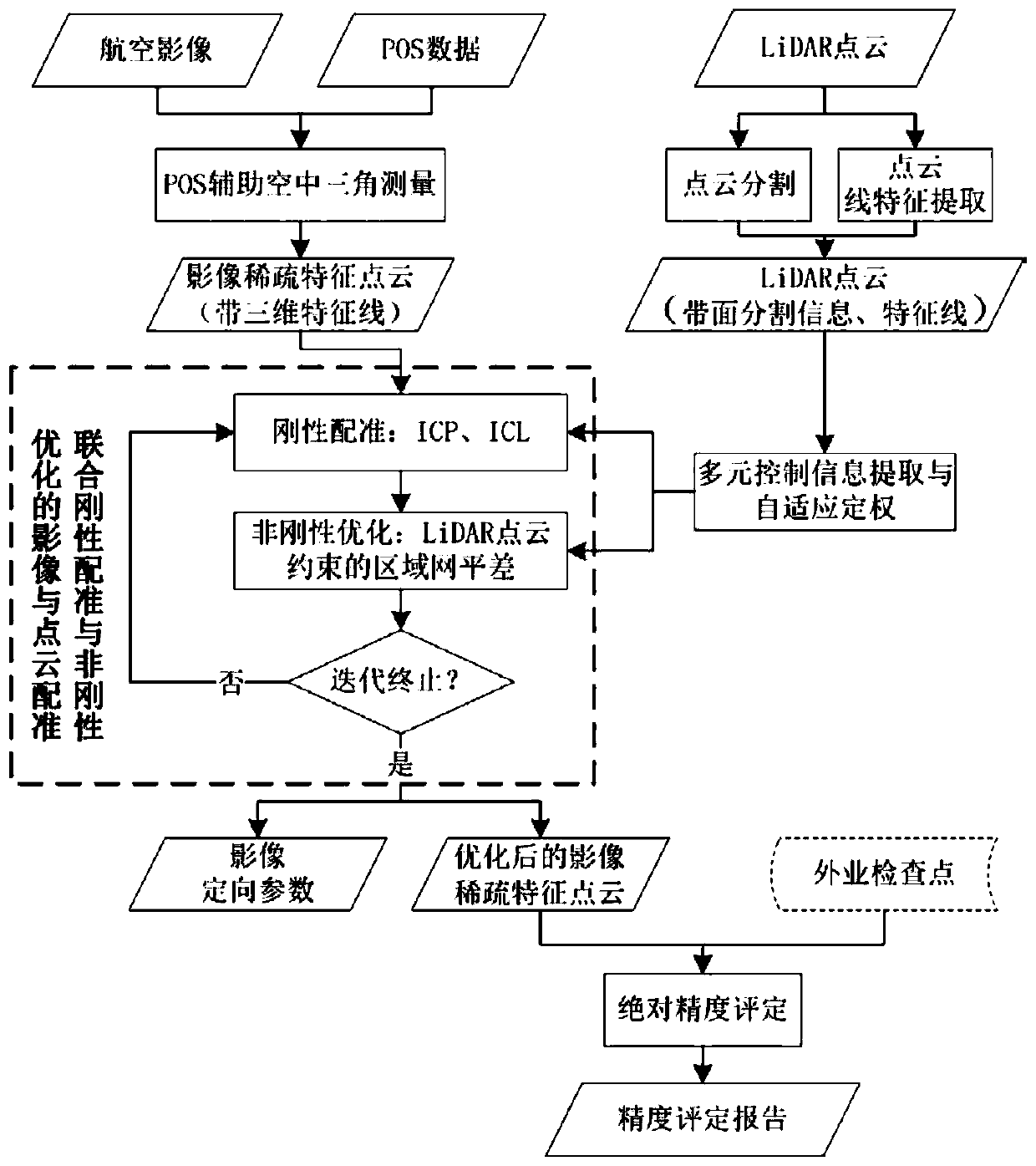
[0035] The technical solution provided by the present invention is to use the existing high-precision LiDAR point cloud as the control, and perform joint rigid registration and non-rigid optimization with the sparse point cloud generated by aerial triangulation of aerial images, so as to realize aerial images without field control points High precision orientation. Such as figure 1 As shown, its core process includes the following steps:

[0036] Step 1. Based on 1450 oblique aerial images with a ground resolution of 5cm (including 291 downward-looking images) taken in the survey area, use the aerial triangulation results of DPGrid software (including camera parameters, image orientation parameters and sparse feature point cloud). And reconstruct the 3D feature line according to the image feature li...


PUM


Abstract

The invention provides a cloud control aerial image photogrammetry method for LiDAR point cloud data. The method comprises the steps that firstly, GPS / POS auxiliary aerial triangulation is conducted on an image, initial camera distortion and image orientation parameters are calculated, and meanwhile sparse feature point cloud and image three-dimensional feature lines are generated; secondly, rigidregistration is performed on the LiDAR point cloud and the image sparse feature point cloud through ICP and ICL algorithms, rigid transformation parameters of the sparse feature point cloud relativeto the LiDAR point cloud are calculated, and exterior orientation elements of the image are updated by using the rigid transformation parameters; and finally, regional network adjustment is carried out under the constraint of LiDAR point cloud control information, and image orientation parameters are optimized. Rigid registration and LiDAR constrained regional network adjustment are repeatedly iterated until the variation of the error in image orientation meets a preset threshold value. According to the method, large-proportion high-precision geometric orientation of the aerial image under thecondition of no field control point is realized by taking the LiDAR point cloud as a geometric reference without dependence on the field control point, and the efficiency of image photogrammetry processing in the information era is greatly improved.

Description

technical field [0001] The invention relates to a LiDAR data "cloud control" aerial image photogrammetry method, which belongs to the field of photogrammetry and computer vision, and in particular relates to a high-precision geometric registration method of images and LiDAR point clouds. Background technique [0002] Informatization and intelligence are the basic characteristics of photogrammetry in the information age. The convenience of image data acquisition and high efficiency of processing have greatly improved the ability of geographic information perception. At present, in the process of urbanization, people's demand for fine 3D geographic information perception of cities is constantly increasing. As an important means of 3D geographic information extraction, traditional photogrammetry technology still relies on high-precision field control points. Even with the auxiliary processing of positioning and attitude determination system (POS), it still cannot get rid of its...

Claims


Application Information

Patent Timeline
Patent Type & Authority Patents(China)
IPC IPC(8): G01C11/34
CPCG01C11/34
Inventor 陶鹏杰张祖勋宋孟肖席可
Owner WUHAN UNIV
Why Eureka
Try Eureka