Gyro measuring instrument being capable of automatically acquiring geographic latitude and automatically seeking north

A technology of geographic latitude and measuring instruments, applied in the direction of rotating gyroscopes, etc., can solve problems such as failure of measurement means, weak anti-interference ability, poor stability of instruments, etc., and achieve strong environmental adaptability, high degree of automation, and high anti-interference ability of the instrument Effect

Active Publication Date: 2019-08-09
CHANGAN UNIV
View PDF10 Cites 1 Cited by
  • Summary
  • Abstract
  • Description
  • Claims
  • Application Information

AI Technical Summary

Problems solved by technology

[0004] 1. In confined space or combat period, it is often impossible to know the geographic latitude of the point to be measured in advance, or the high-precision measurement method fails, and the geographic latitude of the point to be measured cannot be obtained. At this time, it is impossible to use traditional gyro orientation instruments. Orientation measurement
[0005] 2. Failur

Method used


Image

  • Gyro measuring instrument being capable of automatically acquiring geographic latitude and automatically seeking north
  • Gyro measuring instrument being capable of automatically acquiring geographic latitude and automatically seeking north
  • Gyro measuring instrument being capable of automatically acquiring geographic latitude and automatically seeking north

Examples


Embodiment Construction

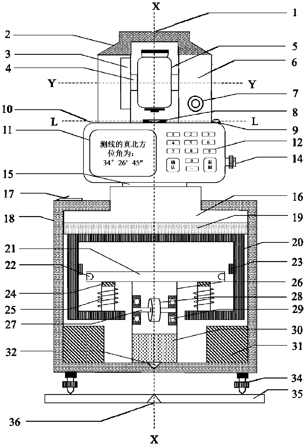
[0045]The present invention discloses a gyro surveying instrument that acquires geographical latitude autonomously and seeks north automatically, which includes an outer shell 18 and an inner shell 20 arranged in the outer shell 18. The surveying instrument also includes: a centering and leveling system, Computer system, collimation system, gyro system, precision angle measurement and rotation system, each system will be further described in detail below.

[0046] Such as image 3 , Figure 4 As shown, the XX axis is the central axis of the present invention and also the central axis of the outer casing 18, the YY axis is the central axis of the vertical rotating shaft 4 of the telescope 5, and the LL axis is the central axis of the level tube α8, and is perpendicular to the XX axis; The L'L' axis is the central axis of the level tube β9 and is perpendicular to the XX axis, and the LL axis and the L'L' axis are on the same horizontal plane. In this embodiment, the inner hous...


PUM


Abstract

The invention discloses a gyro measuring instrument being capable of automatically acquiring a geographic latitude and automatically seeking north. The gyro measuring instrument comprises a centeringleveling system, a microcomputer system, a collimating system, a gyro system, and a precision angle measuring and a rotary system. When the instrument is in use, the gyro system measures a geographiclatitude of a to-be-measured point; the gyro system measures a by-north corner of the instrument; and then the collimating system collimates a target point accurately and measures a horizontal rotation angle to calculate a true north angle of a to-be-measured side. According to the invention, problems that the traditional gyro directional instrument cannot obtain the geographical latitude automatically and gyro orientation cannot be performed under the condition of having unknown latitude are solved. The instrument has advantages of high automation degree, simple operation, high orientation precision, strong adaptability of the instrument environment and high anti-interference ability and the like.

Description

technical field [0001] The invention belongs to the technical fields of geodesy, geodynamics and inertial navigation. It is aimed at the penetration measurement of large-scale projects such as ultra-long tunnels, mines, and urban subways in confined spaces, and can not be obtained by methods such as GPS / BDS during mobile warfare. Missile launch, weapon guidance, azimuth reference, navigation equipment calibration and other problems of geographic latitude parameters necessary for precise orientation, provide a gyro measuring instrument that independently obtains geographic latitude and automatically finds north. Background technique [0002] In terms of national construction, in the construction of large-scale projects such as ultra-long tunnels, mining, and urban subways, in order to ensure their accurate penetration, high-precision orientation and measurement work is required. However, due to the limited space in the tunnel, many high-precision measurement methods cannot be...

Claims


Application Information

Patent Timeline
IPC IPC(8): G01C19/02G01C19/36
CPCG01C19/02G01C19/36
Inventor 杨志强王逸文马骥
Owner CHANGAN UNIV
Why Eureka
Try Eureka