A Fast Indirect Positioning Method for Spaceborne SAR Images Based on DSM Data

A positioning method and image technology, applied in the direction of radio wave reflection/re-radiation, instruments, measuring devices, etc., can solve the problems of time-consuming and low efficiency of Doppler center time

Active Publication Date: 2020-12-08
CHINA ACADEMY OF SPACE TECHNOLOGY
View PDF9 Cites 0 Cited by
  • Summary
  • Abstract
  • Description
  • Claims
  • Application Information

AI Technical Summary

Problems solved by technology

[0007] The technical problem to be solved by the present invention is to solve the problem that the indirect positioning method of the satellite-borne SAR image in the prior art determines the Doppler center time of the target point, which is very time-consuming and inefficient.

Method used


Image

  • A Fast Indirect Positioning Method for Spaceborne SAR Images Based on DSM Data
  • A Fast Indirect Positioning Method for Spaceborne SAR Images Based on DSM Data
  • A Fast Indirect Positioning Method for Spaceborne SAR Images Based on DSM Data

Examples


Embodiment Construction

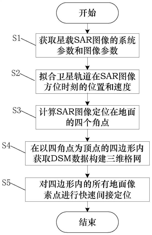
[0102] In order to make the purpose, technical solutions and advantages of the embodiments of the present invention clearer, the technical solutions in the embodiments of the present invention will be clearly and completely described below in conjunction with the drawings in the embodiments of the present invention. Obviously, the described embodiments It is a part of embodiments of the present invention, but not all embodiments. Based on the embodiments of the present invention, all other embodiments obtained by persons of ordinary skill in the art without making creative efforts belong to the protection scope of the present invention.

[0103] like figure 1 As shown, the DSM data-based fast indirect positioning method for spaceborne SAR images provided by the embodiments of the present invention specifically includes the following steps:

[0104] S1. Obtain system parameters and image parameters of spaceborne SAR images.

[0105] Preferably, the system parameters and image...


PUM


Abstract

The invention relates to a DSM data-based rapid indirect positioning method and device for a satellite-borne SAR image, and a computer readable storage medium. The method comprises the steps of acquiring system parameters and image parameters of the satellite-borne SAR image; fitting a satellite orbit curve; determining four angular point coordinates of the SAR image positioned on the ground by anRD model; enabling the four angular point coordinates to form a quadrilateral, and acquiring DSM data in the quadrilateral to construct a three-dimensional grid; and for each ground pixel point in the quadrilateral, determining an orientation position and a distance position corresponding to the ground pixel point by rapidly estimating an orientation moment, thereby realizing indirect positioning. According to the method, the efficiency of determining the orientation moment of a Doppler center by the ground pixel points can be effectively improved, and the determined orientation moment of theDoppler center is the same as the orientation moment of the Doppler center determined by traversing; and the accuracy is high.

Description

technical field [0001] The present invention relates to the technical field of spaceborne synthetic aperture radar image positioning, in particular to a method, device and computer-readable storage medium for fast and indirect positioning of spaceborne SAR images based on DSM data. Background technique [0002] Spaceborne synthetic aperture radar (Synthetic Aperture Radar, SAR) is an active remote sensing system mounted on a satellite and working in the microwave band. Since spaceborne SAR is not limited by sunshine, weather, geography and other factors, it can realize all-day and all-weather earth observation. Therefore, spaceborne SAR has unique advantages in the fields of disaster monitoring, environmental monitoring, ocean observation, resource exploration, crop survey, forest survey, surveying and mapping, and military affairs. [0003] SAR image is a kind of slant-range image. In the azimuth direction, Doppler processing is applied to synthesize the image in azimuth d...

Claims


Application Information

Patent Timeline
Patent Type & Authority Patents(China)
IPC IPC(8): G01S13/90
CPCG01S13/9017G01S13/9004
Inventor 刘敏肖鹏
Owner CHINA ACADEMY OF SPACE TECHNOLOGY
Why Eureka
Try Eureka