Foundation and satellite-borne radar rainfall data fusion method based on wavelet domain regularization

A spaceborne radar and data fusion technology, applied in the direction of rainfall/precipitation gauge, radio wave reflection/re-radiation, character and pattern recognition, etc., can solve the problem of losing the small-scale change details of heavy precipitation and easy smoothing of heavy precipitation etc. to achieve high resolution and reduce uncertainty

Active Publication Date: 2019-09-10
NANJING UNIV OF INFORMATION SCI & TECH
View PDF6 Cites 10 Cited by
  • Summary
  • Abstract
  • Description
  • Claims
  • Application Information

AI Technical Summary

Problems solved by technology

However, the general precipitation data fusion method usually assumes that the prior information of precipitation is Gaussian distribution, so it is easy to smooth out the high-order statistical characteristics and local geometric

Method used


Image

  • Foundation and satellite-borne radar rainfall data fusion method based on wavelet domain regularization
  • Foundation and satellite-borne radar rainfall data fusion method based on wavelet domain regularization
  • Foundation and satellite-borne radar rainfall data fusion method based on wavelet domain regularization

Examples


Embodiment 1

[0049] In order to make the purpose and technical solutions of the present invention clearer, the following in conjunction with specific implementation cases, and with reference to the attached figure 1 , the present invention is further described in detail:

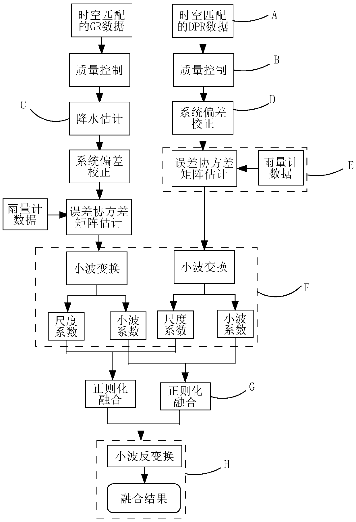
[0050] The ground-based and spaceborne radar precipitation data fusion method based on wavelet domain regularization in this embodiment includes the following specific steps:

[0051] Step A: First, from the spaceborne radar DPR data and the ground-based radar GR data, select the DPR precipitation rate data and GR reflectivity factor data that match in time and space. The selection method is firstly through the known DPR scanning swath width and its The intersecting earth coordinate position, according to the swath shape model, combined with the longitude of the trajectory where the satellite reaches the highest latitude, the satellite orbit intercept and the start time of the orbit, these parameters are used to search f...

Embodiment 2

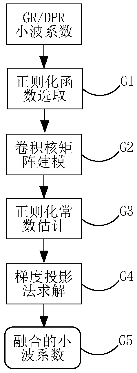
[0082] The further design of this embodiment is: the regularization and fusion process of GR / DPR wavelet coefficients in the above step G is as follows: figure 2 As shown, the following combination figure 2 A detailed description of each step:

[0083] Step G1: According to the characteristics of the scale coefficient and wavelet coefficient of GR / DPR radar precipitation estimation data, select appropriate regularization function items respectively, so as to better maintain or reconstruct small-scale details such as local discontinuous changes of precipitation in the fusion process . The regularization function acts as a constraint on the equation and directly affects the result of the minimized solution.

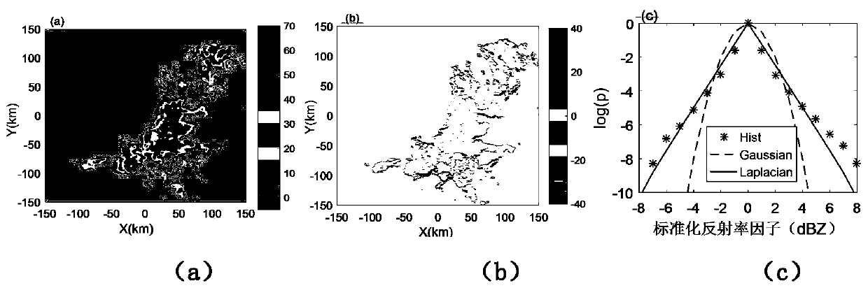
[0084] From image 3 (a)~(c) It can be seen that the probability distribution of wavelet coefficients of radar echo data is non-Gaussian. image 3 (c) The mark * in (c) is the histogram of wavelet coefficients (taking logarithms), and the dotted line is Gaussian distr...

Embodiment 3

[0108] The further design of this embodiment is: the specific flow of the regularized fusion result of solving the wavelet coefficient by the gradient projection method in step G4 is as follows: Figure 4 As shown, each step is described in detail below:

[0109] Step G41: Initialize the parameters in the regularization equation. Given the initial wavelet coefficient d 0 , set the regularization constant β∈(0,1), and set the number of iterations k=0.

[0110] Step G42: Initialize the initial iteration step size α 0 . Calculate α according to the following formula 0 :

[0111]

[0112] To prevent alpha 0 Too large or too small, defined in advance [α min ,α max ], and 0≤α min ≤α max , replacing α 0 = mid[α min ,α 0 ,α max ].

[0113] Step G43: Use the backtracking linear search method to calculate the k-th iteration step size α k , the first value that satisfies the following conditions is α k

[0114]

[0115] Wherein, ε is a constant, generally 0<ε<0.5,...


PUM


Abstract

The invention discloses a foundation and satellite-borne radar rainfall data fusion method based on wavelet domain regularization. The method comprises: based on radar rainfall data wavelet domain statistical characteristics, selecting an appropriate prior model of rainfall data; and determining a regularization function of scale coefficient fusion and wavelet coefficient fusion after wavelet decomposition of the rainfall data of the foundation and the satellite-borne radar, then solving the scale coefficient of the rainfall data and the maximum posteriori estimation of the wavelet coefficientin a wavelet domain by using a gradient projection method, and finally performing wavelet inverse transformation to obtain the optimal rainfall estimation. According to the method, uncertainty of rainfall estimation of different sensors and wavelet domain statistical characteristics of rainfall data are considered in the fusion process. The fusion result reduces the uncertainty of a single sensor, and can better maintain and reconstruct detail features such as a heavy rainfall extreme value and small-scale change, thereby being more beneficial to monitoring and forecasting of heavy disaster weather such as flood monitoring and the like.

Description

[0001] Technical field: [0002] The invention relates to the technical field of meteorological detection data processing, more precisely, relates to a ground-based and spaceborne radar precipitation data fusion method based on wavelet domain regularization. [0003] Background technique: [0004] Accurate estimation of precipitation is of great significance to the study of the temporal and spatial distribution characteristics of precipitation, the development and utilization of water resources, and the forecast and early warning of drought and flood disasters. At present, the main ways to obtain precipitation observation information are: surface rain gauge, ground-based radar and satellite remote sensing detection. Each precipitation observation method has its own advantages and limitations in terms of measurement accuracy, resolution, and coverage. Rain gauges have relatively the highest measurement accuracy for local point measurements. However, actual rainfall has signifi...

Claims


Application Information

Patent Timeline
IPC IPC(8): G06K9/62G01S13/95G01W1/14
CPCG01S13/958G01S13/951G01S13/955G01W1/14G06F18/25Y02A90/10
Inventor 寇蕾蕾阳紫蕾蒋银丰陈爱军楚志刚胡汉峰李南
Owner NANJING UNIV OF INFORMATION SCI & TECH
Why Eureka
Try Eureka