Satellite navigation trusted position service method

A location service and satellite navigation technology, applied in the field of satellite navigation, can solve problems such as increased user costs, inconvenience, and incompatibility with existing terminals, and achieve the effect of improving user experience and better location-based services

Pending Publication Date: 2019-09-17
CHANGSHA TECH RES INST OF BEIDOU IND SAFETY CO LTD
View PDF8 Cites 2 Cited by
  • Summary
  • Abstract
  • Description
  • Claims
  • Application Information

AI Technical Summary

Problems solved by technology

[0003] Due to the long distance from the satellite to the ground, the GNSS signal received by the ground is weak, and the GNSS signal is further blocked or attenuated by the barriers of canyon forests, building walls or roofs, and the GNSS signal can be further weakened when the weather changes badly. , so in the indoor or so-called dark room environment or in the deep mountains and valleys outdoors, the GNSS signal cannot be normal or difficult to be received by the navigation terminal, which brings inconvenience to people's indoor activities or outdoor exploration, transportation and other life
[0004] Based on pseudolite enhancement, ultra-wideband, Bluetooth and other technologies, due to the need to use a dedicated navigation terminal, it cannot be compatible with existing terminals, increasing user costs and making it difficult to promote

Method used


Image

  • Satellite navigation trusted position service method
  • Satellite navigation trusted position service method
  • Satellite navigation trusted position service method

Examples


Embodiment Construction

[0023] In order to make the purpose, technical solutions and advantages of the embodiments of the present invention clearer, the following will clearly and completely describe the technical solutions of the embodiments of the present invention in conjunction with the drawings in the embodiments of the present invention. Obviously, the described embodiments are Some embodiments of the present invention, but not all embodiments. Based on the embodiments of the present invention, all other embodiments obtained by persons of ordinary skill in the art without making creative efforts fall within the protection scope of the present invention.

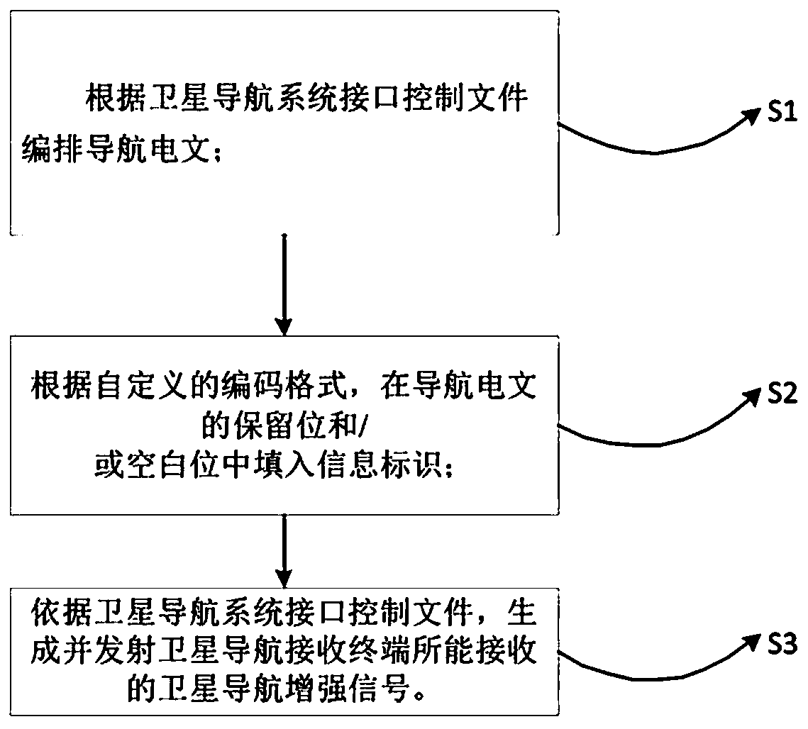
[0024] The present invention will be further described in detail below in conjunction with the accompanying drawings and specific embodiments. figure 1 As shown in the schematic flow chart of the method of the present invention, the present invention provides a satellite navigation trusted location service method, comprising the following step...


PUM


Abstract

The invention relates to the field of satellite navigation, and discloses a satellite navigation trusted position service method. The method comprises the following steps: S1, arranging navigation messages according to a satellite navigation system interface control file; S2, according to a self-defined coding format, filling information identification in the navigation messages, or filling the information identification by utilizing the time gap of broadcasting the navigation messages; and S3, generating and transmitting a satellite navigation enhancement signal which can be received by a satellite navigation receiving terminal according to the satellite navigation system interface control file. According to the method, navigation enhancement signals are generated and transmitted in accordance with a true satellite navigation signal format, and reserved and/or blank bits in the satellite navigation signal navigation messages are used as information identification; and after the navigation terminal receives the navigation enhancement signal, the navigation terminal demodulates the information identifier and gives the information identifier to the application software, and the application software decodes the information identifier to acquire the position and/or the related information so as to realize the service function based on the trusted position.

Description

technical field [0001] The invention relates to the field of satellite navigation, in particular to a satellite navigation trusted location service method. Background technique [0002] Satellite navigation systems represented by GPS, GLONASS, Beidou, and Galileo can provide users with cheap, 24-hour uninterrupted positioning services by transmitting radio frequency signals through medium and high orbit satellites. The basic components of mobile phones and wearable devices have become the basic means for people to travel, obtain location information and location-based services, and the user base is extremely large. [0003] Due to the long distance from the satellite to the ground, the GNSS signal received by the ground is weak, and the GNSS signal is further blocked or attenuated by the barriers of canyon forests, building walls or roofs, and the GNSS signal can be further weakened when the weather changes badly. Therefore, in indoor or so-called darkroom environments or i...

Claims


Application Information

Patent Timeline
Patent Type & Authority Applications(China)
IPC IPC(8): G01S19/42
CPCG01S19/42
Inventor 刘志俭明德祥钟小鹏乔纯捷刘春阳杨建伟
Owner CHANGSHA TECH RES INST OF BEIDOU IND SAFETY CO LTD
Why Eureka
Try Eureka