A method for super-resolution land cover mapping of remote sensing images based on street view images

A remote sensing image and super-resolution technology, applied in the field of geospatial information, can solve problems such as the difficulty of accurately identifying the object category and extracting the spatial location and range

Active Publication Date: 2021-06-22
INST OF GEOGRAPHICAL SCI & NATURAL RESOURCE RES CAS
View PDF8 Cites 0 Cited by
  • Summary
  • Abstract
  • Description
  • Claims
  • Application Information

AI Technical Summary

Problems solved by technology

However, it is still difficult to accurately identify the object category, extract the spatial location and range from the picture

Method used


Image

  • A method for super-resolution land cover mapping of remote sensing images based on street view images
  • A method for super-resolution land cover mapping of remote sensing images based on street view images
  • A method for super-resolution land cover mapping of remote sensing images based on street view images

Examples


Embodiment Construction

[0044] The present invention will be described in detail below in conjunction with the accompanying drawings and embodiments.

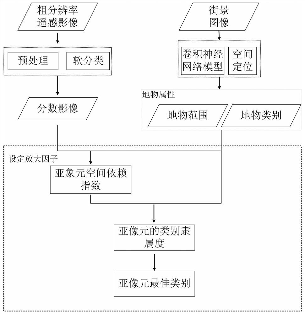
[0045] like figure 1 Shown, the present invention is concretely realized as follows:

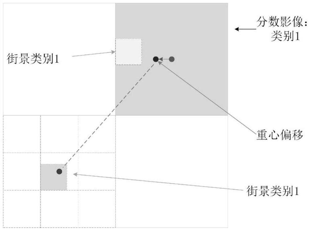
[0046] Step 1. Obtain the category ratio data of the remote sensing image: perform preprocessing such as correction and denoising on the remote sensing image, and use the soft classification method to obtain the area ratio of each feature category in each pixel of the remote sensing image, also known as abundance or fractional image;

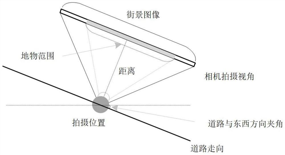
[0047] Step 2. Obtain the attributes of the street view objects: use CNN to obtain the category and depth of field of the objects in the street view image;

[0048] The CNN model is built on the basis that the local features of the image are highly correlated and the features of the local features do not change with the position. Therefore, CNN has inherent advantages in automatic image extraction, and it has reached the accuracy of...


PUM


Abstract

The invention discloses a remote sensing image super-resolution land cover mapping method based on a street view image. Firstly, the remote sensing image is preprocessed, and the score image is obtained by soft classification method; at the same time, the convolutional neural network model (Convolutional Neural Network, CNN for short) and spatial positioning technology are used to extract the feature information of the street view image. Secondly, according to the set magnification factor, the ground objects in the street view image are located, and the area ratio of the sub-pixels they occupy is calculated. Then, considering the category and location attributes of the ground objects in the fractional image and the street view image, the spatial dependence index of the sub-pixel is calculated. Finally, according to the spatial dependence index of the sub-pixel and the area ratio of the sub-pixel, the class membership degree of the sub-pixel is obtained, and then the super-resolution land cover mapping result is obtained. The invention constructs a theoretical model of a remote sensing image super-resolution land cover mapping method based on a street view image, which can fuse high-resolution image surface feature information, and the mapping result has high precision.

Description

technical field [0001] The invention relates to a super-resolution mapping method, which belongs to the technical field of geospatial information. Background technique [0002] Due to the influence of the external environment, internal sensors, and the distribution of ground objects, remote sensing images cannot fully describe the distribution of ground objects during the acquisition process, which makes mixed pixels (Mixed Pixel) common in remote sensing images (De Jong et al, 2004). The existence of mixed pixels restricts the information extraction and application of remote sensing images, especially the mixed pixels will bring errors and uncertainties to the traditional hard classification (Atkinson, 2009; Ge Yong and Li Sanping, 2008) . In order to solve the uncertainty of the hard classification method, the soft classification method is proposed, which refers to describing the area ratio of various types of ground objects in the mixed pixel in the form of category prop...

Claims


Application Information

Patent Timeline
Patent Type & Authority Patents(China)
IPC IPC(8): G06K9/00G06T3/40
CPCG06T3/4053G06V20/13
Inventor 葛咏贾远信赵维恒
Owner INST OF GEOGRAPHICAL SCI & NATURAL RESOURCE RES CAS
Why Eureka
Try Eureka