Vehicle cooperative navigation method based on relative motion model

A collaborative navigation and relative motion technology, applied in navigation, surveying and navigation, navigation through speed/acceleration measurement, etc., can solve problems such as difficulty in providing navigation information and unavailability of satellite navigation systems, and achieve the effect of improving accuracy

Active Publication Date: 2019-09-27
NANJING UNIV OF AERONAUTICS & ASTRONAUTICS
View PDF9 Cites 9 Cited by
  • Summary
  • Abstract
  • Description
  • Claims
  • Application Information

AI Technical Summary

Problems solved by technology

[0002] In the existing technology, the navigation system widely used in vehicles is mostly realized by inertial device (IMU-accelerometer and gyroscope) / satellite integrated navigation system, but when the vehicle is driving in an environment with occlusion such as tunnels, the satellite signal is affected by Shading makes the satellite navigation system unavailable, and the inertial / satellite integrated navigation system will be difficult to provide accurate navigation information

Method used


Image

  • Vehicle cooperative navigation method based on relative motion model
  • Vehicle cooperative navigation method based on relative motion model
  • Vehicle cooperative navigation method based on relative motion model

Examples


specific Embodiment approach

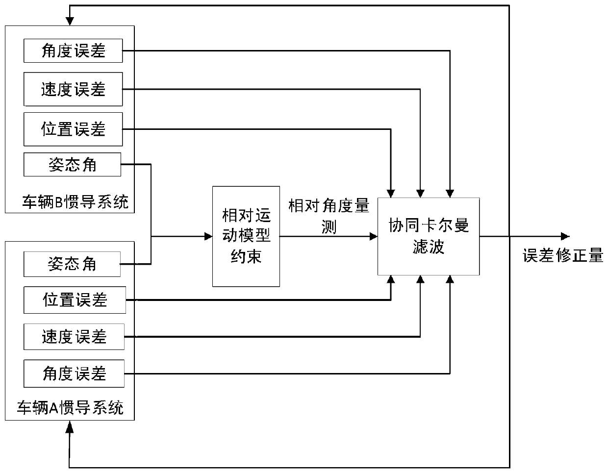
[0077] 1. Establish the state equation of the vehicle cooperative navigation method based on relative motion model constraints

[0078] First define the coordinate system: the geographic coordinate system selects "East-North-Sky" as the navigation system (n), and the carrier coordinate system (b) selects "Right-Front-Up". The state vector of the vehicle collaborative navigation system is:

[0079]

[0080] Among them, X is the state vector of the cooperative navigation system, X A is the state vector of vehicle A in the cooperative navigation system, X B is the state vector of vehicle B in the cooperative navigation system, is the platform error angle of the inertial navigation system of vehicle A, are the three-axis mathematical platform error angles of the strapdown inertial navigation system x, y, z of vehicle A respectively, δV A is the speed error of vehicle A, is the speed error of the three-axis northeast sky of vehicle A, δp A is the position error of vehic...


PUM


Abstract

The invention discloses a vehicle cooperative navigation method based on a relative motion model, and belongs to the technical field of vehicle cooperative navigation. The method comprises the following steps: firstly building a state equation of a cooperative navigation system on the basis of an inertial navigation system error equation; then using a Doppler frequency shift effect to calculate frequency deviation, caused by relative motions of vehicles, of a vehicle-mounted wireless radio, and then judging relative meeting time; establishing a vehicle relative motion model and a measurement equation on the basis of the relative motion mode during meeting; finally carrying out discretization on the state equation and the measurement equation, carrying out measurement updating during meeting, and carrying out feedback correction on the state quantity of the system to realize effective amending for the cooperative navigation system. According to the method, relative motion constraint information of vehicles can be utilized effectively in satellite navigation failure environments such as tunnel, effective fusion with inertial navigation is realized, the precision and reliability of the vehicle navigation system are improved, and the method is applicable for engineering application.

Description

technical field [0001] The invention relates to a vehicle cooperative navigation method based on relative motion model constraints, and belongs to the technical field of vehicle cooperative navigation. Background technique [0002] In the existing technology, the navigation system widely used in vehicles is mostly realized by inertial device (IMU-accelerometer and gyroscope) / satellite integrated navigation system, but when the vehicle is driving in an environment with occlusion such as tunnels, the satellite signal is affected by Shading makes the satellite navigation system unusable, and the inertial / satellite integrated navigation system will be difficult to provide accurate navigation information. Therefore, in the event of satellite failure, it is necessary to collect available navigation information as much as possible. When vehicles traveling in opposite directions on the same road meet each other, there are certain rules in their relative motion. Using the relative m...

Claims


Application Information

Patent Timeline
Patent Type & Authority Applications(China)
IPC IPC(8): G01C21/00G01C21/18G06F17/16G06F17/18
CPCG01C21/005G01C21/18G06F17/16G06F17/18
Inventor 陈明星熊智李文龙李欣童张玲王融曾庆化田世伟
Owner NANJING UNIV OF AERONAUTICS & ASTRONAUTICS
Why Eureka
Try Eureka