An integrated navigation method for crab pond automatic operation ships based on information fusion of low-precision GPS, laser ranging sensor and azimuth sensor

An azimuth sensor and laser ranging technology, applied in surveying and navigation, navigation, navigation calculation tools, etc., can solve the problems of large equipment investment, complex heading control algorithms, etc., to avoid collisions, improve stability and anti-interference ability Effect

Active Publication Date: 2021-02-12
JIANGSU UNIV
View PDF4 Cites 0 Cited by
  • Summary
  • Abstract
  • Description
  • Claims
  • Application Information

AI Technical Summary

Problems solved by technology

However, this method requires the accuracy of the navigation system to reach the centimeter level, the investment in equipment is large, and the heading control requires a more complex algorithm.

Method used


Image

  • An integrated navigation method for crab pond automatic operation ships based on information fusion of low-precision GPS, laser ranging sensor and azimuth sensor
  • An integrated navigation method for crab pond automatic operation ships based on information fusion of low-precision GPS, laser ranging sensor and azimuth sensor
  • An integrated navigation method for crab pond automatic operation ships based on information fusion of low-precision GPS, laser ranging sensor and azimuth sensor

Examples


Embodiment Construction

[0035] Specific embodiments of the present invention will be further described below in conjunction with the accompanying drawings.

[0036] The invention proposes a combined navigation method for an automatic operation ship in crab ponds based on information fusion of low-precision GPS, a laser ranging sensor and an azimuth sensor, which is used to realize the navigation of the automatic operation ship in crab ponds. The technical solution adopted by the present invention to solve its technical problems comprises the following steps:

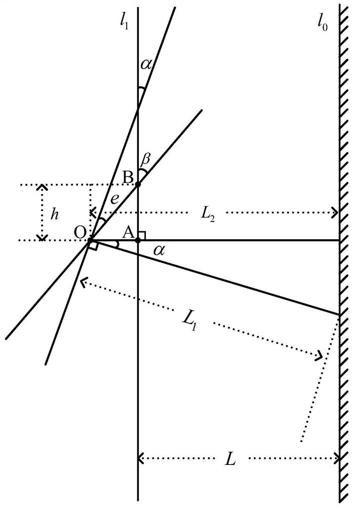
[0037] (j) Plan the target route of the operation ship, the distance L between the target route and the embankment, the target point of the next position and the position information of the turning point through the data of the GPS system, such as figure 1 shown. When the workboat travels to the relevant position, it starts to turn or switch the corresponding track line.

[0038] (k) Determining the current heading angle α of the workboat thr...


PUM


Abstract

The invention discloses a combined navigation method for a crab pond automatic operation ship based on information fusion of low-precision GPS, a laser ranging sensor and an azimuth sensor, which is used for realizing the navigation of the crab pond automatic operation ship. The navigation method of the automatic operation ship is to start from a certain point, parallel to the embankment of the pond, and an inner spiral path at a certain distance. The invention uses a low-precision GPS system to determine the position of the inflection point of the navigation track and the track heading, uses an azimuth sensor to determine the current direction of movement of the automatic operation ship, and uses a laser ranging sensor to determine the distance between the automatic operation ship and the nearby embankment. The difference between the current course angle and the expected course angle is obtained by using the distance between the workboat and the embankment, combined with the current course angle, and through certain mathematical calculations. The angle deviation value is introduced into the paddle wheel motor drive control system, and the PD control method is used to adjust the speed difference between the left and right paddle wheels, so as to realize the course control of the operation ship, thereby realizing the navigation of the crab pond automatic operation ship.

Description

technical field [0001] The invention relates to the field of mixed use of navigation and multi-sensors, in particular to a combined navigation method for an automatic operation ship in crab ponds based on information fusion of low-precision GPS, laser ranging sensors and azimuth sensors. Background technique [0002] With the continuous development of the economy, people's living standards have improved significantly, and the market's demand for river crabs has increased year by year. The river crab breeding ponds planted with grass have high labor costs, low operating efficiency, and the level of automation, modernization, and high efficiency is obviously not high. Therefore, an automatic navigation aquaculture workboat is designed. During the navigation process of the workboat, generally only a separate navigation system is used to realize the positioning, course and steering control of the ship. However, this method requires the accuracy of the navigation system to reac...

Claims


Application Information

Patent Timeline
Patent Type & Authority Patents(China)
IPC IPC(8): G01C21/00G01C21/20G01S17/08G01S17/93
CPCG01C21/005G01C21/203G01S17/08G01S17/93
Inventor 赵德安钱梦男秦云孙月平
Owner JIANGSU UNIV
Why Eureka
Try Eureka