Method for automatically calculating water surface height of large shallow lake

A computational method and highly automatic technology, applied in the field of surveying and mapping science, which can solve the problems of sufficient large lakes, high cost of real-time water level observation stations, and difficulty in quantitatively obtaining lake volumes.

Active Publication Date: 2019-10-15
JIANGXI PROVINCIAL WATER CONSERVANCY PLANNING ANDDESIGNING INST
View PDF8 Cites 9 Cited by
  • Summary
  • Abstract
  • Description
  • Claims
  • Application Information

AI Technical Summary

Problems solved by technology

[0003]Due to the high cost of deploying real-time water level observation stations, it is difficult to deploy enough real-time water level observation stations in large lakes to meet the needs of hydrological calculations. Observation methods are difficult to obtain the instantaneous water surface elevation of the whole lake at a certain moment, which makes it difficult to quantitatively obtain the volume of the lake, which brings inconvenience to hydrological calculation and flood analysis

Method used


Image

  • Method for automatically calculating water surface height of large shallow lake
  • Method for automatically calculating water surface height of large shallow lake
  • Method for automatically calculating water surface height of large shallow lake

Examples


Embodiment Construction

[0045] The following will clearly and completely describe the technical solutions in the embodiments of the present invention with reference to the accompanying drawings in the embodiments of the present invention. Obviously, the described embodiments are only some, not all, embodiments of the present invention. Based on the embodiments of the present invention, all other embodiments obtained by persons of ordinary skill in the art without making creative efforts belong to the protection scope of the present invention.

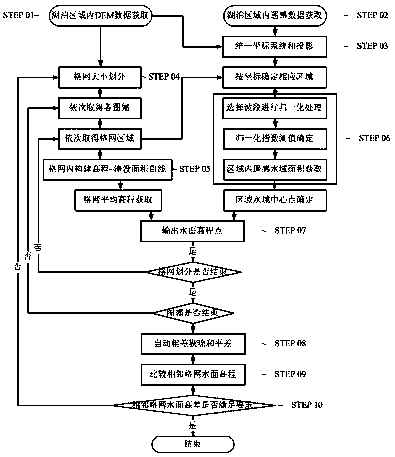
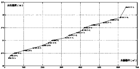
[0046] see Figure 1~5 , in an embodiment of the present invention, a method for automatically calculating the water surface height of a large shallow lake includes the following steps:

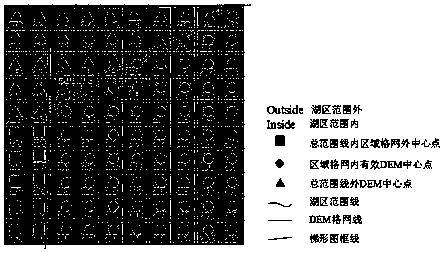
[0047] (1) To obtain the DEM in the lake area, first use the underwater topographic survey method or other professional survey methods to obtain the digital elevation model DEM in the lake;

[0048] (2) Obtain Landsat images;

[0049] (3) Use ENVI professional image process...


PUM


Abstract

The invention relates to the field of surveying and mapping science and technology, and discloses a method for automatically calculating the water surface height of a large shallow lake. The method comprises the steps of obtaining DEM in a lake area; acquiring a Landsat image in the lake area; unifying and projecting a coordinate system; selecting the size of a grid; constructing a water surface area-water surface elevation relation curve in a regional grid A; obtaining the area of a TM image water area in the regional grid; automatically calculating the average water surface height in the regional grids; carrying out automatic gross error elimination and adjustment; comparing the elevations of adjacent grids; when the difference between the water surface elevations of the adjacent grids is too large, subdividing the grids, and repeating the size selection of the grids; and when the difference between the water surface elevations of the adjacent grids meets the requirement, outputtingthe water surface elevation of each grid. According to the method, the satellite instantaneous remote sensing image and the actually measured DEM data are fused, the instantaneous water surface elevation of the large lake in the grid can be obtained through automatic grid division and fusion calculation under the condition of ignoring the topographic change of the shallow lake, the precision is superior to 0.2 m, and the problem of obtaining the instantaneous water surface elevation of the large shallow lake is solved.

Description

technical field [0001] The present invention relates to surveying and mapping science and technology, in particular to a method for automatically calculating the water surface height of large shallow lakes, in particular to the fusion of remote sensing images and actual measured DEM data to obtain the remote sensing water area in the regional grid and the water surface area-water surface elevation in the region Curve method to automatically calculate water surface elevation. Background technique [0002] In large shallow lakes, due to the uncertain water flow around and the large lake range, the upstream and downstream drops are relatively large. There is even a difference of more than ten meters, resulting in an extremely irregular state of the lake water surface, and the grid water surface elevation varies greatly in different regions. [0003] Due to the high cost of deploying real-time water level observation stations, it is difficult to deploy enough real-time water le...

Claims


Application Information

Patent Timeline
Patent Type & Authority Applications(China)
IPC IPC(8): G06T17/05G06T7/62
CPCG06T17/05G06T7/62G06T2207/10032
Inventor 周航宇柯劲松杨智翔张冬张李荪刘金生
Owner JIANGXI PROVINCIAL WATER CONSERVANCY PLANNING ANDDESIGNING INST
Why Eureka
Try Eureka