Integrated SATPS total survey station

a total survey station and integrated technology, applied in active open surveying means, surveying instruments, instruments, etc., can solve the problems of inconsistent errors, inconvenient approach, and large time-consuming to perform,

Inactive Publication Date: 2002-04-09
TRIMBLE NAVIGATION LTD
View PDF14 Cites 66 Cited by
  • Summary
  • Abstract
  • Description
  • Claims
  • Application Information

AI Technical Summary

Problems solved by technology

The methods used at that time were simple but subject to consistency errors and required considerable time to perform.
This approach would not be suitable where the ship or other body whose angular orientation is to be determined can move over a large region.
However, the angular displacement is limited to a small angular sweep, such as 12.degree..
Several limitations exist in use of a conventional total station.
First, it is difficult to quickly establish the angular orientation and absolute location of a local survey or datum.
Third, the electronic total station relies upon line-of-sight contact between the survey instrument and the

Method used


Image

  • Integrated SATPS total survey station
  • Integrated SATPS total survey station
  • Integrated SATPS total survey station

Examples


Embodiment Construction

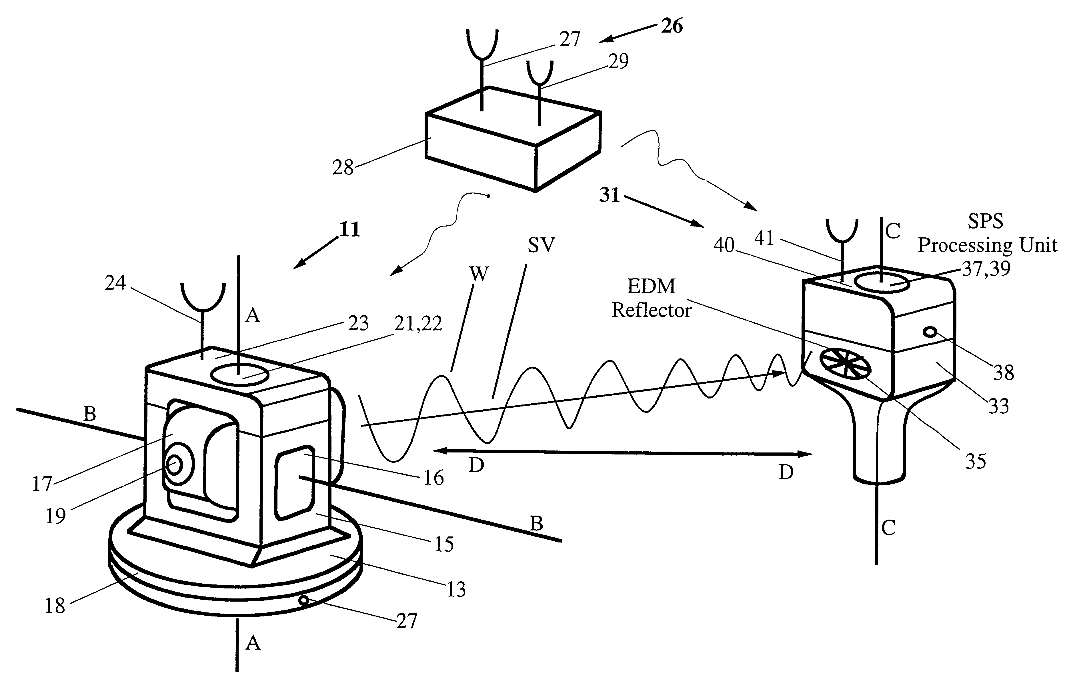
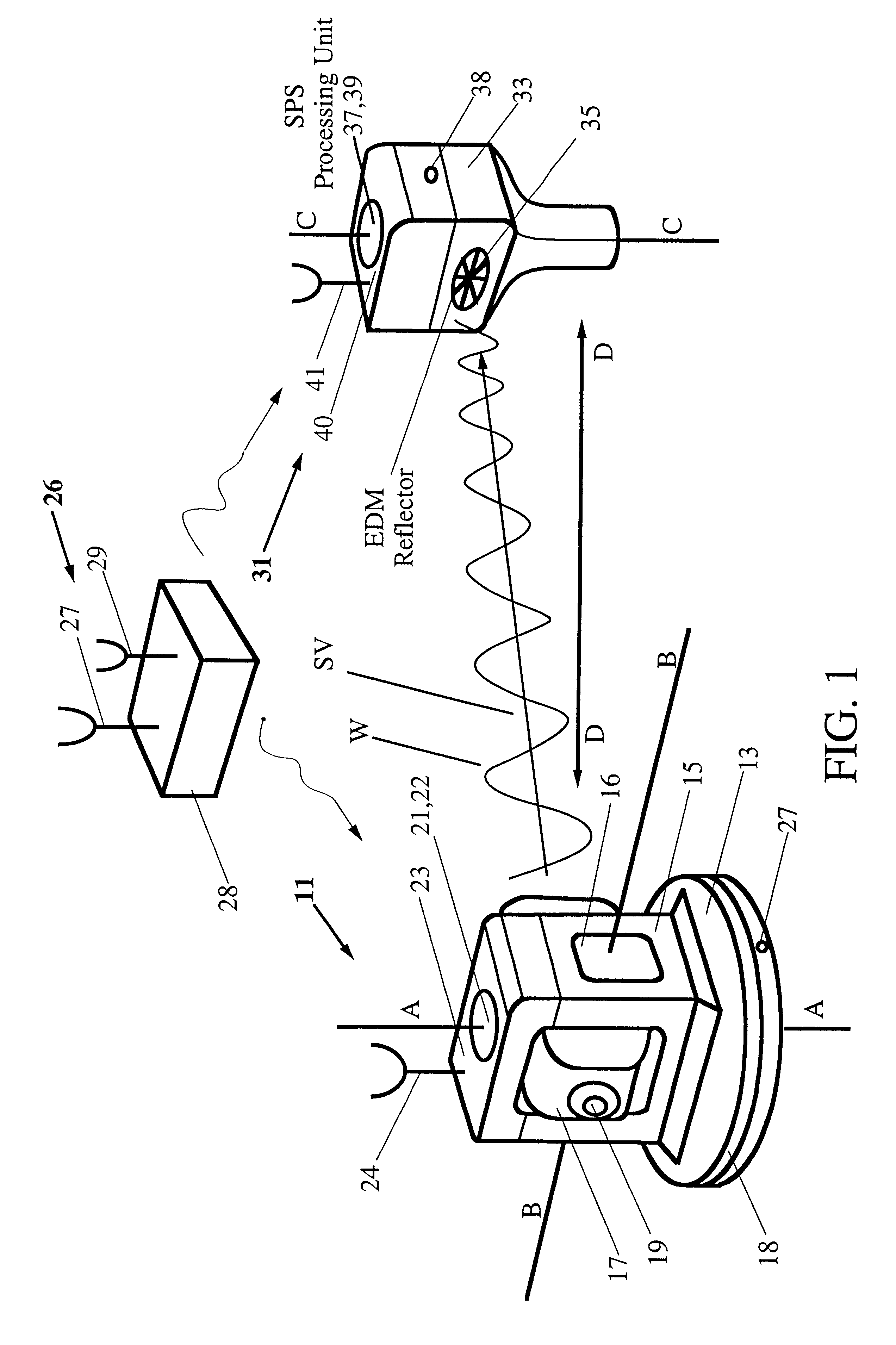
FIG. 1 illustrates many of the components included in an SATPS instrument station 11 and an SATPS mobile station 31 according to one embodiment of the invention. The instrument station 11 includes a plate 13 mounted on a tripod or other stable structure (not shown) and rotatable about an approximately vertical first axis AA that passes through the plate 13. A second body 15, referred to as the alidade, is mounted on a top surface of the plate 13 and is either rotatable about the first axis AA with respect to the plate 13 or rotates with the plate 13 about the first axis AA. A third body 17 is positioned adjacent to or surrounded by the alidade 15 and rotates about an approximately horizontal second axis BB, referred to as the trunnion or horizontal axis, with respect to the alidade 15. The third body 17 includes an EDM 19 that may be aimed or pointed in an arbitrary direction (over a hemisphere with included solid angle approximately 2.pi. steradians) with the aid of rotations of th...


PUM


Abstract

Apparatus for measuring surveying parameters, such as distances and angular displacements between an instrument survey station and a mobile survey station, with improved accuracy. The invention combines a differential satellite positioning system (DSATPS), available with positioning systems such as GPS and GLONASS, with electromagnetic measurements of distances and optically encoded angles by a conventional electro-optical survey instrument to provide survey measurements that can be accurate to within a few millimeters in favorable situations. The DSATPS relies upon pseudorange measurements or upon carrier phase measurements, after removal of certain phase integer ambiguities associated with carrier phase SATPS signals. The SATPS may be retrofitted within the housing of the conventional electro-optical instrument. In a first approach, a remote station provides DSATPS corrections for the mobile station and/or for the instrument station. In a second approach, the mobile station provides DSATPS corrections for itself and for the instrument station. In a third approach, the instrument station provides DSATPS corrections for itself and for the mobile station.

Description

BACKGROUND OF THE INVENTIONAs noted by A. Bannister and S. Raymond in Surveying, Pitman Publishing Ltd., London, 1977, the general notion of surveying was known and practiced more than 2000 years ago. The methods used at that time were simple but subject to consistency errors and required considerable time to perform. Surveying instruments have improved considerably since about 1900, taking advantage of advances in electronics, optics and other related disciplines. Recently, lasers, electro-optics, wave interaction and phase detection have been introduced into, and used in, surveying activities.Use of a laser beam projector for surveying operations is disclosed in U.S. Pat. No. 3,471,234, issued to Studebaker. The beam rotates over terrain to be surveyed, and a beam point may be directed to a particular location and used to measure elevation and angular displacements within the region covered by the rotating beam.Altman, in U.S. Pat. No. 3,669,548, discloses a method for determining...

Claims


Application Information

Patent Timeline
IPC IPC(8): G01C15/00G01S5/14G01S19/14G01S19/35G01S19/37
CPCG01C15/002G01S19/41G01S19/33G01S19/44
Inventor NICHOLS, MARKTALBOT, NICHOLAS C.
Owner TRIMBLE NAVIGATION LTD
Why Eureka
Try Eureka