Constructing virtual control point constrained multi-source multi-coverage remote sensing image adjustment method

A virtual control point, remote sensing image technology, applied in image enhancement, image analysis, photo interpretation and other directions, can solve problems such as adjustment value deviation, achieve the effect of improving adaptability, improving stability, and avoiding huge deviations

Active Publication Date: 2019-10-29
INST OF REMOTE SENSING & DIGITAL EARTH CHINESE ACADEMY OF SCI
View PDF4 Cites 14 Cited by
  • Summary
  • Abstract
  • Description
  • Claims
  • Application Information

AI Technical Summary

Problems solved by technology

[0040] In view of the above problems, the purpose of the present invention is to provide a multi-source multi-coverage remote sensing image adjustment method constrained by virtual control points, which can effectively solve the huge deviation of the adjustment value caused by the different geometric relationships during the multi-source image adjustment. problems, make full use of the complementarity of different source images, so that the positioning accuracy of each dimension can be taken into account during the adjustment

Method used


Image

  • Constructing virtual control point constrained multi-source multi-coverage remote sensing image adjustment method
  • Constructing virtual control point constrained multi-source multi-coverage remote sensing image adjustment method
  • Constructing virtual control point constrained multi-source multi-coverage remote sensing image adjustment method

Examples


Embodiment Construction

[0085] In order to make the purpose, technical solutions and advantages of the embodiments of the present invention clearer, the technical solutions in the embodiments of the present invention will be clearly and completely described below in conjunction with the drawings in the embodiments of the present invention. Obviously, the described embodiments It is a part of embodiments of the present invention, but not all embodiments. Based on the embodiments of the present invention, all other embodiments obtained by persons of ordinary skill in the art without making creative efforts belong to the protection scope of the present invention.

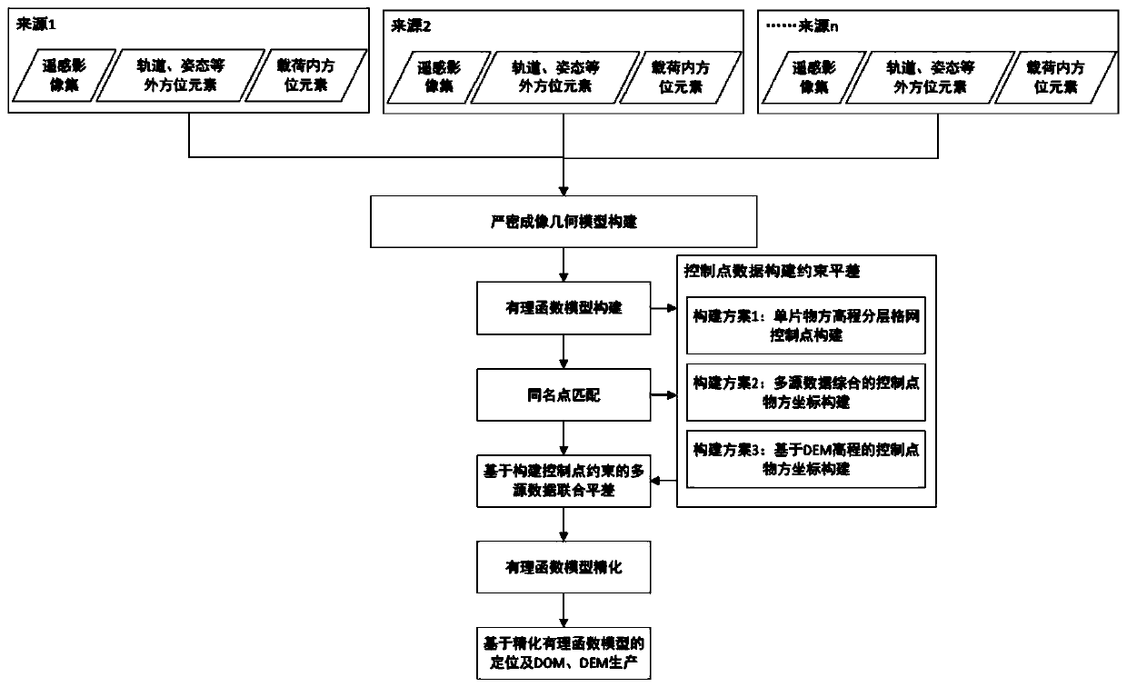
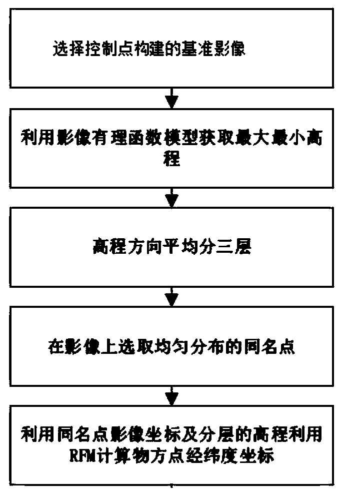
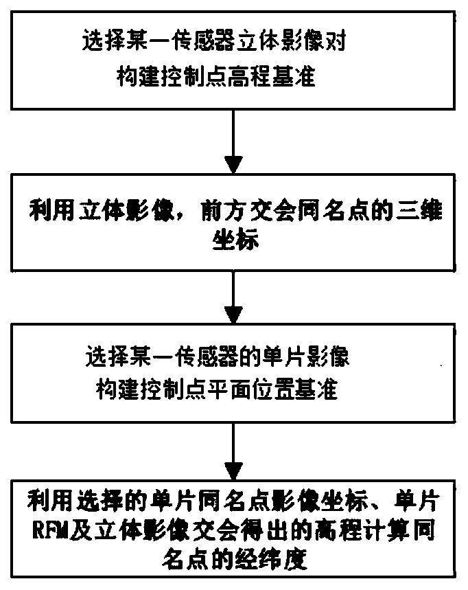
[0086] Such as figure 1 As shown, the multi-source multi-coverage remote sensing image adjustment method for constructing virtual control point constraints provided by the present invention includes the following contents:

[0087] 1. Construct the image imaging geometric model.

[0088] At present, the commonly used imaging geometric model...


PUM


Abstract

The invention relates to a constructing virtual control point constrained multi-source multi-coverage remote sensing image adjustment method that comprises the following steps: S1, constructing an image imaging geometric model; S2, performing image matching on a stereo remote sensing image pair to obtain homonymous points of the remote sensing images; S3, constructing control points based on imagecharacteristics of different sensors; S4, performing multi-source data joint adjustment based on control point constraint; and S5, outputting refined parameters of a rational function model, and completing the multi-source block adjustment based on the RFM. According to the calculation method of the virtual control points, object space three-dimensional coordinates of the control points can be adaptively determined according to an intersection result of the homologous three-dimensional model, so that the adjustment solving stability and precision are remarkably improved.

Description

technical field [0001] The invention relates to a multi-source multi-coverage remote sensing image adjustment method constrained by constructing virtual control points, and relates to the technical field of photography and imaging. Background technique [0002] In the field of earth observation and deep space exploration, the use of satellite remote sensing images for planetary surface detection and mapping is an important means of planetary surface mapping and remote sensing detection. With the development of deep space exploration technology, the exploration of extraterrestrial planets has entered a new golden age. The United States, Japan, China, India and other countries have successively carried out planetary exploration activities, and remote sensing images with multiple missions and multiple coverages have been obtained. With the continuous increase of detectors, various detectors acquire a large amount of data in the same area, so that the same area has a large numbe...

Claims


Application Information

Patent Timeline
Patent Type & Authority Applications(China)
IPC IPC(8): G01C11/06G06T7/33
CPCG01C11/06G06T2207/10032G06T7/33
Inventor 刘斌邸凯昌尹力
Owner INST OF REMOTE SENSING & DIGITAL EARTH CHINESE ACADEMY OF SCI
Why Eureka
Try Eureka