
Field navigation method and system based on dynamic carrier phase difference technology

A technology of carrier phase difference and navigation method, applied in the field of field navigation, can solve the problem of low positioning accuracy and achieve the effect of high accuracy

Inactive Publication Date: 2019-12-03
北京麦飞科技有限公司
View PDF22 Cites 6 Cited by
  • Summary
  • Abstract
  • Description
  • Claims
  • Application Information

AI Technical Summary

Problems solved by technology

[0003] However, in the existing field navigation systems, the traditional GPS system is often used to obtain positioning data, and the positioning accuracy is not high, often between 3 and 5 meters

Method used


Image

  • Field navigation method and system based on dynamic carrier phase difference technology
  • Field navigation method and system based on dynamic carrier phase difference technology
  • Field navigation method and system based on dynamic carrier phase difference technology

Examples


Embodiment Construction

[0049]Certain terms are used, for example, in the description and claims to refer to particular components. Those skilled in the art should understand that hardware manufacturers may use different terms to refer to the same component. The specification and claims do not use the difference in name as a way to distinguish components, but use the difference in function of components as a criterion for distinguishing. As mentioned throughout the specification and claims, "comprising" is an open term, so it should be interpreted as "including but not limited to". "Approximately" means that within an acceptable error range, those skilled in the art can solve the technical problem within a certain error range and basically achieve the technical effect. The subsequent description of the specification is a preferred implementation mode for implementing the application, but the description is for the purpose of illustrating the general principle of the application, and is not intended ...


PUM


Abstract

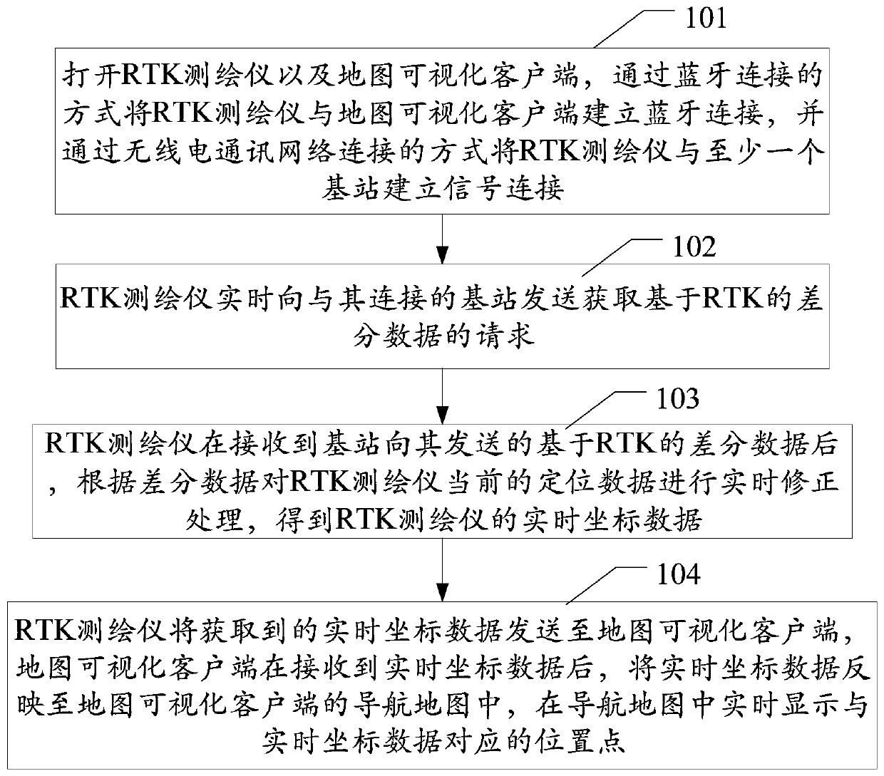
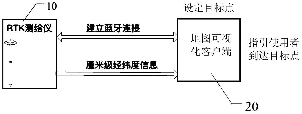
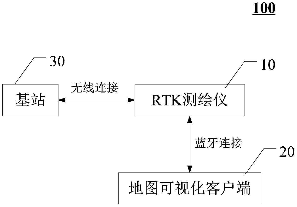
The application, which relates to the technical field of field navigation, discloses a field navigation method and system based on a dynamic carrier phase difference technology. The method comprises:opening an RTK surveying instrument and a map visualization client, establishing Bluetooth connection between the RTK surveying instrument and the map visualization client, and establishing signal connection between the RTK surveying instrument and a base station; sending a request for acquiring RTK-based differential data to a base station connected with the RTK surveying instrument in real timeby the RTK surveying instrument; after receiving of the differential data by the RTK surveying instrument, correcting current positioning data in real time according to the differential data to obtainreal-time coordinate data; and sending the obtained real-time coordinate data to the map visualization client by the RTK surveying instrument, receiving the real-time coordinate data by the map visualization client, reflecting the real-time coordinate data to a navigation map of the map visualization client, and displaying a position point corresponding to the real-time coordinate data in the navigation map in real time. Therefore, the positioning precision is improved.

Description

technical field [0001] The present application relates to the technical field of field navigation, in particular, to a field navigation method and system based on dynamic carrier phase difference technology. Background technique [0002] The application of GPS in navigation has been relatively mature, but less research has been done in farmland application. At present, there are researches on providing positioning and navigation for field robots, such as automatic navigation and auxiliary navigation for agricultural vehicles. This method can effectively reduce the work intensity of farmers, improve agricultural production efficiency, and reduce agricultural accidents such as pesticide poisoning and sunburn. And can promote the development of precision agriculture. [0003] However, in the existing field navigation systems, the traditional GPS system is often used to obtain positioning data, and the positioning accuracy is not high, often between 3 and 5 meters. In order to...

Claims


Application Information

Patent Timeline
Patent Type & Authority Applications(China)
IPC IPC(8): G01S19/43G01S19/41G06F16/29
CPCG01S19/41G01S19/43G06F16/29
Inventor 郭朝贺施蕾蕾刘龙宫华泽陈祺
Owner 北京麦飞科技有限公司
Learn More