A pm2.5 Concentration Estimation Method Based on Geostationary Orbit Satellites

A static orbit and concentration technology, applied in the field of remote sensing, can solve the problems of long revisit period of the same point and unable to reflect the migration of pollutants well.

Active Publication Date: 2021-05-18
INST OF REMOTE SENSING & DIGITAL EARTH CHINESE ACADEMY OF SCI +2
View PDF8 Cites 0 Cited by
  • Summary
  • Abstract
  • Description
  • Claims
  • Application Information

AI Technical Summary

Problems solved by technology

Among them, satellite remote sensing data mostly come from polar-orbiting satellites, that is, sun-synchronous orbiting satellites. Because their orbits pass through the Earth’s north and south poles and are synchronous with the sun, their revisit periods at the same point are generally longer. For example, the MODIS (moderate-resolution imaging spectrometer) Imaging spectroradiometer) data is acquired twice a day (10:30 and 13:30 Beijing time). The PM2.5 concentration estimation based on this remote sensing data cannot reflect the migration of pollutants well. There are still many problems in the estimation of PM2.5 concentration

Method used


Image

  • A pm2.5 Concentration Estimation Method Based on Geostationary Orbit Satellites
  • A pm2.5 Concentration Estimation Method Based on Geostationary Orbit Satellites
  • A pm2.5 Concentration Estimation Method Based on Geostationary Orbit Satellites

Examples


Embodiment Construction

[0050] In order to make the object, technical solution and advantages of the present invention clearer, the present invention will be further described in detail below in combination with specific embodiments and with reference to the accompanying drawings. It should be understood that these descriptions are exemplary only, and are not intended to limit the scope of the present invention. Also, in the following description, descriptions of well-known structures and techniques are omitted to avoid unnecessarily obscuring the concept of the present invention.

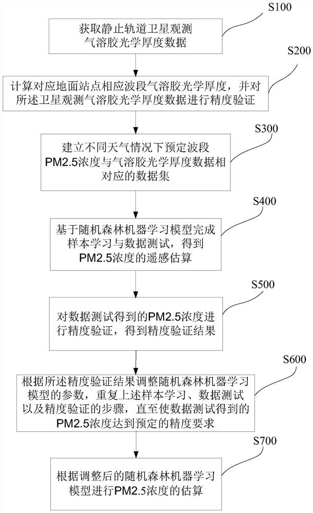
[0051] The invention provides a method for estimating PM2.5 concentration based on geostationary satellites. According to the correlation relationship between aerosol optical thickness data and PM2.5 concentration, the remote sensing estimation of PM2.5 concentration under different weather conditions can be performed quickly and accurately. The estimation result of PM2.5 concentration can be obtained accurately.

[0052...


PUM


Abstract

A PM2.5 concentration estimation method based on geostationary satellites, which uses aerosol optical depth data that meets the accuracy requirements and the corresponding PM2.5 concentration data to establish a data set, and completes sample learning and data testing based on the random forest machine learning method. The accuracy of the test results is verified, and the parameters of the random forest machine learning model are adjusted to meet the accuracy requirements, and the multi-temporal PM2.5 concentration estimation under different weather conditions is performed through the final calculation model. The remote sensing estimation method of PM2.5 concentration based on geostationary satellites of the present invention can effectively perform multi-temporal remote sensing estimation of PM2.5 concentration, make up for the lack of time continuity of traditional methods, and provide more accurate data for air pollution prevention and control support.

Description

technical field [0001] The invention relates to the technical field of remote sensing, in particular to a method for estimating PM2.5 concentration based on geostationary orbit satellites. Background technique [0002] With the sustained and rapid development of my country's industrialization and urbanization, people's living standards have risen sharply, and more and more environmental problems have also emerged. In recent years, large-scale continuous smog has occurred in China many times. The smog is mainly composed of PM2.5, which can enter the lungs. PM2.5 refers to particles with an aerodynamic diameter of less than 2.5 μm. Compared with PM10, PM2.5 has a smaller particle size and can be absorbed in the atmosphere Long-term stay and long-distance transmission have a greater impact on the quality of the air environment; PM2.5 is easy to attach to various toxic and harmful substances (such as persistent organic pollutants, heavy metals, various pathogenic bacteria, etc.)...

Claims


Application Information

Patent Timeline
Patent Type & Authority Patents(China)
IPC IPC(8): G01N15/06G06N20/00
CPCG01N15/06G01N2015/0693G06N20/00
Inventor 左欣顾行发程天海郭红余涛张晓川
Owner INST OF REMOTE SENSING & DIGITAL EARTH CHINESE ACADEMY OF SCI
Why Eureka
Try Eureka