High-precision map drawing method acting in agricultural field

A map drawing and field technology, applied in the field of map drawing, can solve problems such as failure of detection of agricultural machinery failures, and achieve the effect of optimal work efficiency

Inactive Publication Date: 2019-12-20
上海思深宇维信息科技有限公司
View PDF0 Cites 6 Cited by
  • Summary
  • Abstract
  • Description
  • Claims
  • Application Information

AI Technical Summary

Problems solved by technology

[0005] Aiming at the deficiencies of the prior art, the present invention provides a high-precision map drawing method in the agricultural field, which has the advantages of being able to quickly plan driving paths, and can analyze and judge agricultural machinery failures, and solves the problem that agricultural machinery driving paths require manual real-time The problem that the failure of agricultural machinery cannot be detected during operation

Method used


Image

  • High-precision map drawing method acting in agricultural field
  • High-precision map drawing method acting in agricultural field
  • High-precision map drawing method acting in agricultural field

Examples


Embodiment 1

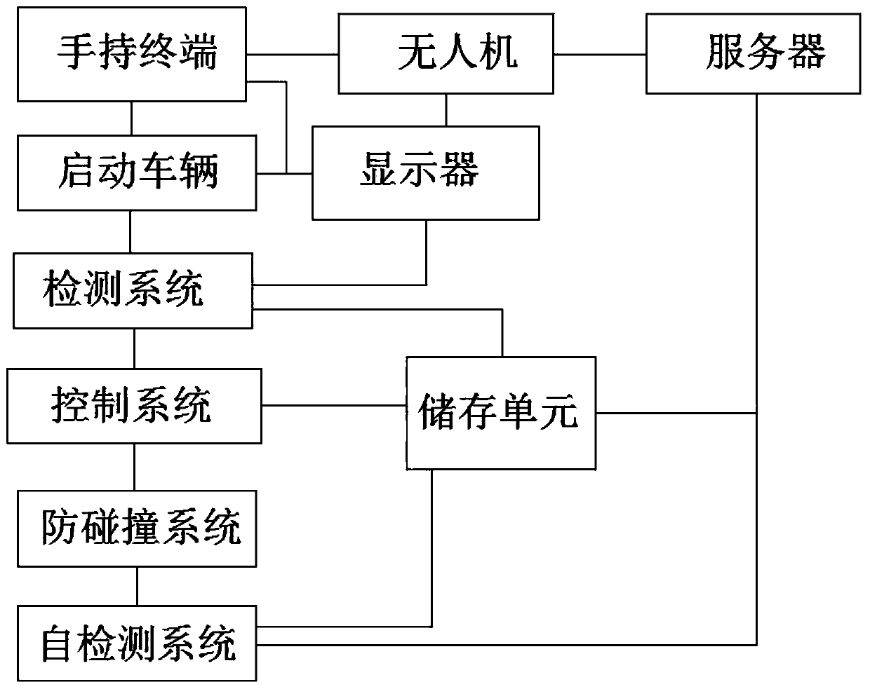
[0029] see Figure 1-3 , a high-precision map drawing method acting in the agricultural field, comprising the following steps:

[0030] Step 1: Start the handheld terminal and control the drone to measure the target area;

[0031] Step 2: Start the agricultural machinery vehicle, the detection system obtains the location information of the vehicle, and obtains the driving path of the vehicle according to the measurement data of the drone, and transmits the path data to the display;

[0032] Step 3: The control system receives and executes the path planning data, and controls the agricultural machinery vehicle to drive according to the path planning data;

[0033] Step 4: The anti-collision system is turned on, so that the vehicle automatically avoids obstacles;

[0034] Step 5: The self-inspection system detects vehicle faults, and the detection data is uploaded to the storage unit and server at any time.

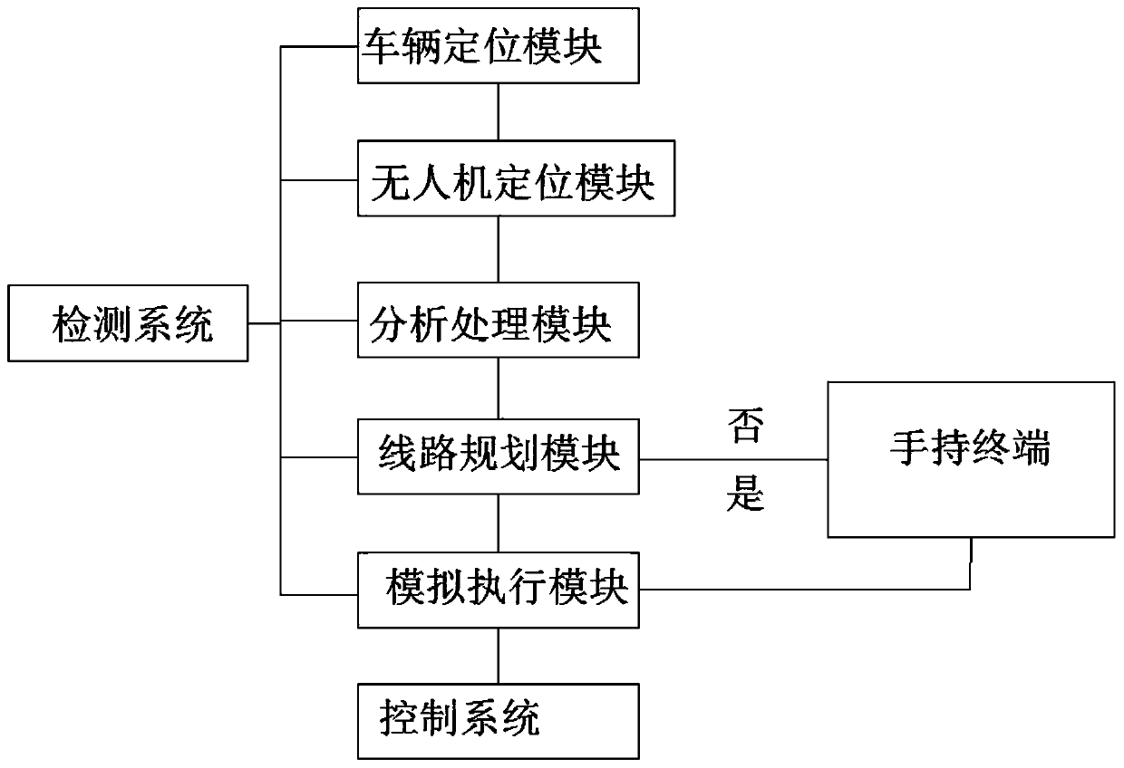
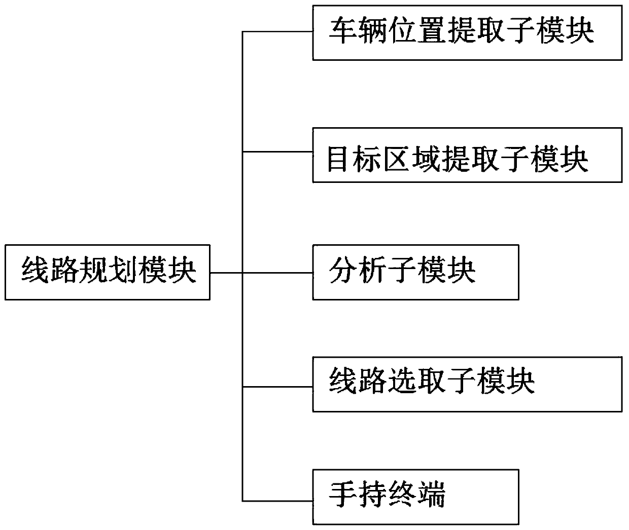
[0035]The detection system includes vehicle positioning module, UAV...

Embodiment 2

[0037] see Figure 1-3 , a high-precision map drawing method acting in the agricultural field, comprising the following steps:

[0038] Step 1: Start the handheld terminal and control the drone to measure the target area;

[0039] Step 2: Start the agricultural machinery vehicle, the detection system obtains the location information of the vehicle, and obtains the driving path of the vehicle according to the measurement data of the drone, and transmits the path data to the display;

[0040] Step 3: The control system receives and executes the path planning data, and controls the agricultural machinery vehicle to drive according to the path planning data;

[0041] Step 4: The anti-collision system is turned on, so that the vehicle automatically avoids obstacles;

[0042] Step 5: The self-inspection system detects vehicle faults, and the detection data is uploaded to the storage unit and server at any time.

[0043] The detection system includes vehicle positioning module, UA...


PUM


Abstract

The invention relates to the technical field of map drawing, and discloses a high-precision map drawing method acting in the agricultural field. The method comprises the following steps: starting a hand-held terminal, operating and controlling an unmanned aerial vehicle to measure a target area, starting an agricultural vehicle, obtaining vehicle position information by a detection system, and obtaining a vehicle driving path according to the measurement data of the unmanned aerial vehicle, transmitting path data to a display, receiving and executing, by a control system, path planning data, operating and controlling the agricultural vehicle to travel according to the path planning data, starting an anti-collision system to enable the vehicle to automatically avoid obstacles, detecting, bya self-inspection system, a vehicle fault, and uploading detection data to a storage unit and a server at any time. By adopting the high-precision map drawing method acting in the agricultural field,a driving path can be planned quickly, the labor intensity of manually operating the machinery is reduced, and the faults of the agricultural machinery can also be analyzed and judged to to enable technicians to maintain the agricultural machinery conveniently.

Description

technical field [0001] The invention relates to the technical field of map drawing, in particular to a high-precision map drawing method used in the agricultural field. Background technique [0002] Fully automatic agricultural machinery, which uses technical means such as automatic control and electronic computers to realize the automation of agricultural production and management, is one of the important symbols of agricultural modernization. The mechanization of agriculture has realized the replacement of manpower and animal power with mechanical power and electricity, and the replacement of human hand tools with working machinery. Since the 1970s, agriculture has gradually popularized and applied technologies such as automatic control, electronic computers, system engineering, and remote sensing to realize the automation of some production operations and management, and achieved effects such as improving operation quality, efficiency, safety, and labor saving. Agricultu...

Claims


Application Information

Patent Timeline
Patent Type & Authority Applications(China)
IPC IPC(8): G05D1/10G01C21/20
CPCG01C21/20G05D1/101
Inventor 田春雨梁左思熊淮
Owner 上海思深宇维信息科技有限公司
Why Eureka
Try Eureka