FPGA-based real-time remote sensing image geographic reference method

A reference method, remote sensing image technology, applied in image data processing, photo interpretation, graphic image conversion, etc. The system can not meet the real-time and other problems, to achieve the effect of fast running speed and low power consumption

Inactive Publication Date: 2019-12-24
TIANJIN UNIV
View PDF2 Cites 1 Cited by
  • Summary
  • Abstract
  • Description
  • Claims
  • Application Information

AI Technical Summary

Problems solved by technology

[0002] With the continuous advancement of technology, remote sensing image data is more and more widely used in natural disasters and positioning systems. These systems need to provide geographic coordinates quickly and in real time. However, traditional remote sensing image data does not have geographic coordinates, and traditional The processing system can not meet the real-time requirements, mainly in the following aspects: (1) The primary remote sensing images that are generally processed and distributed by the ground receiving station are affected by various factors, and there is a certain geometric distortion, mainly manifested as displacement, Rotation, scaling, affine, bending, and higher order bending, or squashing, stretching, twisting, or offsetting the actual position of the cell relative to the ground
(2) General remote sensing images do not have geographic coordinates
[0005] The general remote sensing image processing process is to receive and download data through the ground receiving station, perform image preprocessing to form remote sensing data of different levels, and then send them to users after processing according to different user needs. This process is very time-consuming. Obviously, when natural disasters such as fires and earthquakes occur, it is necessary to give the precise geographic coordinates of the specific location of the disaster in real time, so the general system cannot meet the real-time requirements. The FPGA-based real-time geographic reference system is a solution to this problem. method

Method used


Image

  • FPGA-based real-time remote sensing image geographic reference method
  • FPGA-based real-time remote sensing image geographic reference method
  • FPGA-based real-time remote sensing image geographic reference method

Examples


Embodiment Construction

[0045] In order to make the object, technical solution and advantages of the present invention clearer, the implementation manner of the present invention will be further described in detail below in conjunction with the accompanying drawings.

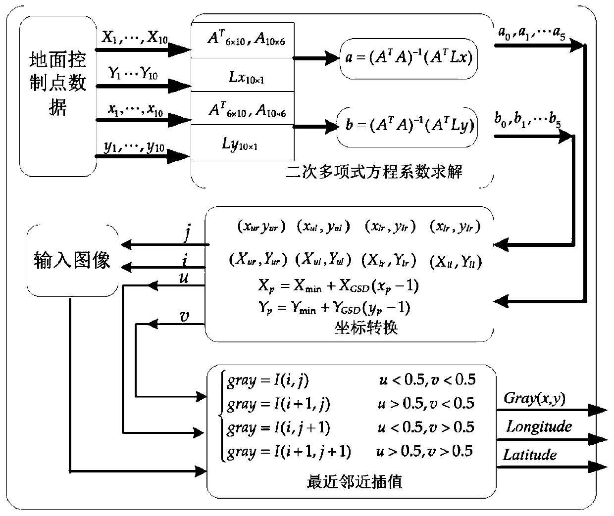
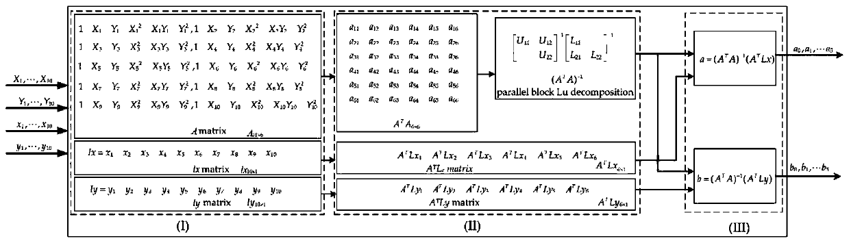
[0046] The first step: quadratic polynomial coefficient solution

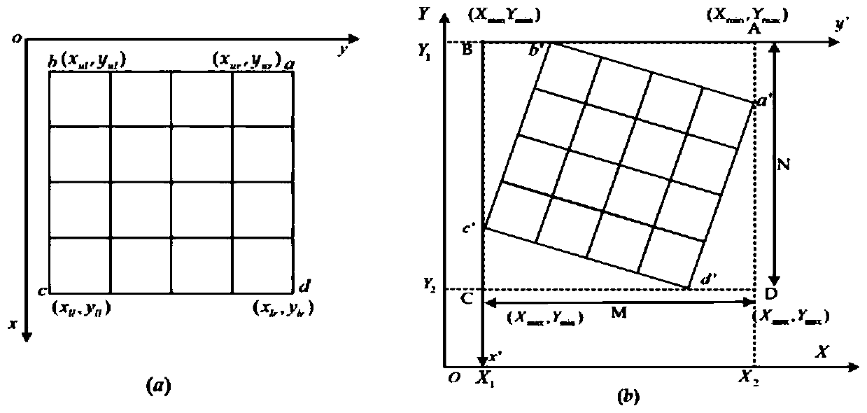
[0047] First, establish the coordinate conversion equation between the image to be corrected and the reference image. At present, there are mainly strict imaging models, polynomial models and rational function models. In this patent, the quadratic polynomial model is used to construct the quadratic polynomial according to the known control point data pairs. Eq., and finally, the optimal quadratic polynomial coefficients are solved cyclically using the method of least squares.

[0048] Real-time geo-referencing of remote sensing images based on FPGA-based second-order polynomial structure block diagram figure 1 As shown, it mainly includes three main parts: establishme...


PUM


Abstract

The invention discloses an FPGA-based real-time remote sensing image geographic reference method. The method comprises the steps of: S1. selecting geographic reference image coordinates to construct acontrol point-to-coordinate relationship model; S2. selecting corresponding coordinate parameters from the control point-to-coordinate relationship model to convert to-be-corrected image coordinates(xg, yg); S3, judging whether the to-be-corrected image coordinates (xg, yg) are positive numbers, and if so, entering the next step; otherwise, ending; S4, judging whether the to-be-corrected image coordinates (xg, yg) are within a selected geographic reference image range, and if so, entering the next step; otherwise, ending; and S5, obtaining a gray value of the to-be-corrected image coordinates (xg, yg) through the nearest-neighbor interpolation algorithm, and performing resampling to output a remote sensing image with geographic coordinates. The method is implemented by using FPGA as hardware, the design hardware language is the Verilog_HDL language, the algorithm code simulation is effective, and the real-time output of the geographic reference images is realized.

Description

technical field [0001] The invention relates to the field of remote sensing image processing, in particular to an FPGA-based real-time remote sensing image geographic reference method. Background technique [0002] With the continuous advancement of technology, remote sensing image data is more and more widely used in natural disasters and positioning systems. These systems need to provide geographic coordinates quickly and in real time. However, traditional remote sensing image data does not have geographic coordinates, and traditional The processing system can not meet the real-time requirements, mainly in the following aspects: (1) The primary remote sensing images that are generally processed and distributed by the ground receiving station are affected by various factors, and there is a certain geometric distortion, mainly manifested as displacement, Rotation, scaling, affine, bending, and higher order bending, or squashing, stretching, twisting, or offsetting the actual...

Claims


Application Information

Patent Timeline
Patent Type & Authority Applications(China)
IPC IPC(8): G01C11/04G06T3/60
CPCG01C11/04G06T3/604
Inventor 刘德全周国清张荣庭舒磊王凡周详黄景金
Owner TIANJIN UNIV
Why Eureka
Try Eureka