Indoor and outdoor integrated positioning and navigation method and system

A positioning and navigation, indoor and outdoor technology, applied in the field of indoor and outdoor integrated positioning and navigation methods and systems thereof, can solve problems such as cumulative error, increased positioning error, and sensor error.

Active Publication Date: 2020-01-03
CHENGDU LINGQI SPACE SOFTWARE +1
View PDF4 Cites 7 Cited by
  • Summary
  • Abstract
  • Description
  • Claims
  • Application Information

AI Technical Summary

Problems solved by technology

However, due to the error of the sensor, this technology will cause the cumulative error in the positioning process, and the positioning error will increase with the growth of time, so it needs to be integrated with Bluetooth positioning to eliminate the cumulative error

Method used


Image

  • Indoor and outdoor integrated positioning and navigation method and system
  • Indoor and outdoor integrated positioning and navigation method and system
  • Indoor and outdoor integrated positioning and navigation method and system

Examples


Embodiment 1

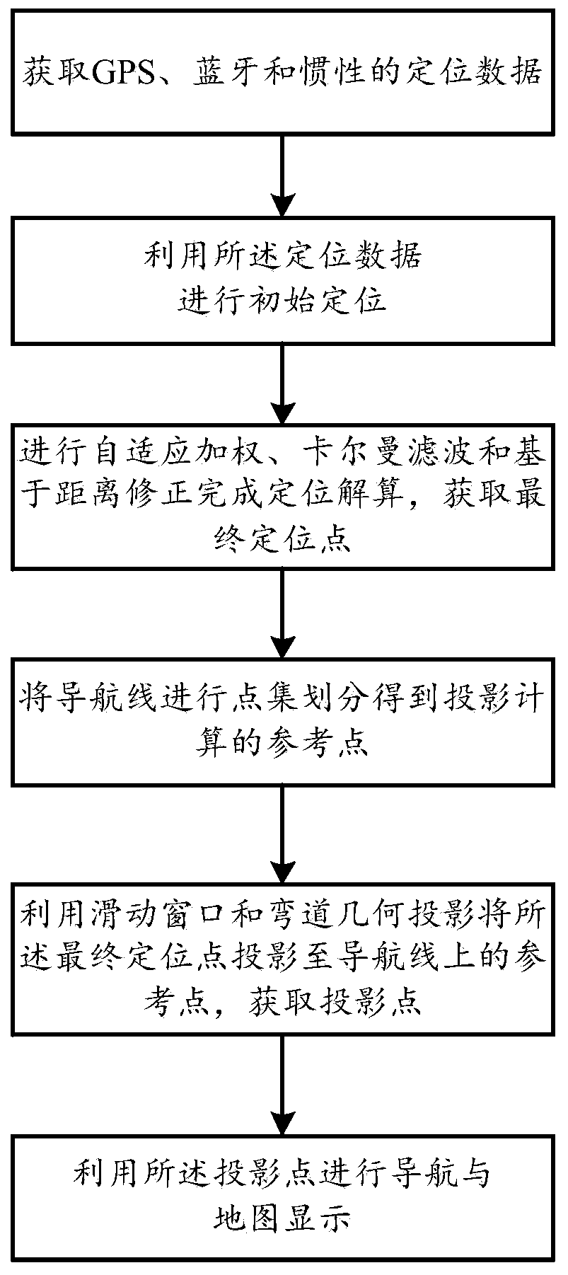
[0075] An indoor and outdoor integrated positioning and navigation method, comprising the following steps:

[0076] Step 1: After obtaining GPS, Bluetooth and inertial positioning data, use the positioning data to perform initial positioning;

[0077] Step 2: The positioning data after the initial positioning is adaptively weighted, Kalman filter and based on distance correction to complete the positioning calculation, and obtain the final positioning point;

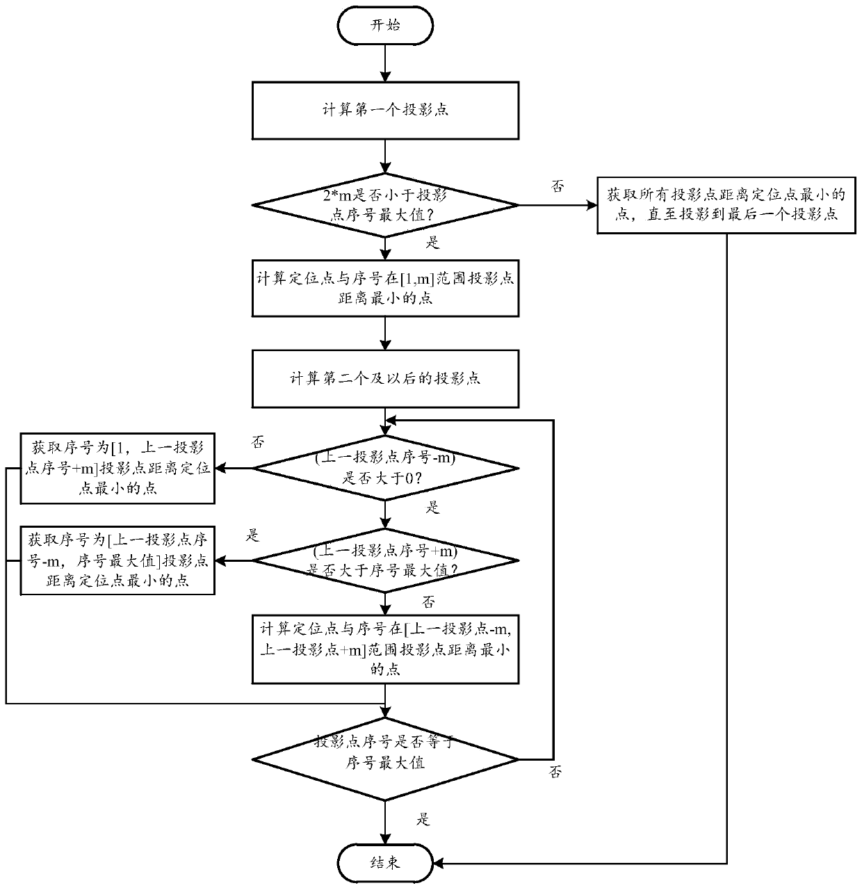
[0078] Step 3: divide the navigation line into point sets to obtain reference points for projection calculation, and use the sliding window and curve geometric projection to project the final positioning point to the reference point on the navigation line to obtain the projection point;

[0079] Step 4: Use the projected points for navigation and map display.

[0080] Described step 1 comprises the following steps:

[0081] Step 1.1: Obtain GPS, Bluetooth and inertial positioning data, the GPS positioning data includes...

Embodiment 2

[0166] Based on the method of Embodiment 1, a system is provided, the system includes a processor, a memory, and a computer program stored in the memory and operable on the processor "Step 1: Acquiring GPS, Bluetooth and inertial positioning data Finally, use the positioning data for initial positioning; step 2: perform adaptive weighting, Kalman filtering, and distance correction based on the positioning data after the initial positioning to complete positioning calculations to obtain the final positioning point; step 3: point the navigation line The reference point for projection calculation is obtained by set division, and the final positioning point is projected to the reference point on the navigation line by using the sliding window and curve geometric projection to obtain the projection point; step 4: use the projection point for navigation and map display. ”, the computer program can be divided into one or more modules / units, and the one or more modules / units are stored...


PUM


Abstract

The present invention discloses an indoor and outdoor integrated positioning and navigation method and system, and relates to the field of positioning fusion. The method comprises: step 1: obtaining GPS, Bluetooth and inertial positioning data; step 2: after performing adaptive weighting, Kalman filtering and distance-based correction on the positioning data to complete positioning solving to obtain a final positioning point; step 3: performing point set division on a navigation line to obtain a reference point for projection calculation, and using a sliding window and curve geometric projection to project the final positioning point onto the reference point of the navigation line to obtain a projection point; and step 4: using the projection point for navigation and map display. Accordingto the technical scheme of the present invention, an adaptive weighting and Kalman filtering model is used to obtain a smooth positioning result, and distance-based correction is performed on the result to obtain stable and accurate positioning, so that the difficulties of the calculation amount, the real-time performance and stability caused by the fusion of inertial positioning, Bluetooth positioning and GPS positioning are overcome, and smooth indoor and outdoor integrated positioning and navigation can be achieved.

Description

technical field [0001] The invention relates to the field of positioning fusion, in particular to an indoor and outdoor integrated positioning and navigation method and system thereof. Background technique [0002] With the rapid development of GPS positioning, a series of LBS-based services are increasing and becoming more mature, such as traffic navigation and location presentation. However, when indoors, the GPS signal is severely interfered, and accurate indoor positioning cannot be achieved, and the demand for indoor positioning is increasing day by day, such as shopping guides in indoor shopping malls, indoor parking guidance, hospital guidance, etc. [0003] Indoor positioning mostly relies on several sensors for positioning, such as WIFI, Bluetooth, infrared, geomagnetism, etc. However, due to the complex indoor environment and many obstacles, the positioning accuracy based on wireless sensors is greatly affected by the environment, and the positioning accuracy is u...

Claims


Application Information

Patent Timeline
IPC IPC(8): G01C21/16G01S19/46G01S19/47G06F17/10
CPCG01C21/165G01S19/46G01S19/47G06F17/10
Inventor 熊运余何梦园袁钰涵刘辉
Owner CHENGDU LINGQI SPACE SOFTWARE
Why Eureka
Try Eureka