High-sensitivity satellite navigation precise capture method

A satellite navigation and high-sensitivity technology, applied in the field of high-sensitivity satellite navigation and fine-acquisition, can solve the problems that incoherent integration cannot satisfy satellite signal capture in high-dynamic scenarios, and the incoherent integration takes a long time to capture, so as to improve data and pseudocode. phase, eliminating the effect of limiting, reducing the effect of system power consumption

Active Publication Date: 2020-01-03
BEIJING AUTOMATION CONTROL EQUIP INST
View PDF5 Cites 2 Cited by
  • Summary
  • Abstract
  • Description
  • Claims
  • Application Information

AI Technical Summary

Problems solved by technology

[0005] (1) Long-term non-coherent integration is required to achieve relatively high sensitivity;
[0006] (2) Long-term non-coherent integration cannot meet the requirements of satellite signal acquisition in high dynamic scenes;
[0007] (3) Long time non-coherent integration capture time is longer

Method used


Image

  • High-sensitivity satellite navigation precise capture method
  • High-sensitivity satellite navigation precise capture method

Examples


Embodiment Construction

[0035] The present invention is described in detail below in conjunction with specific embodiment:

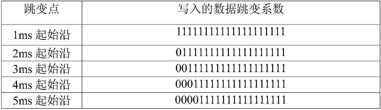
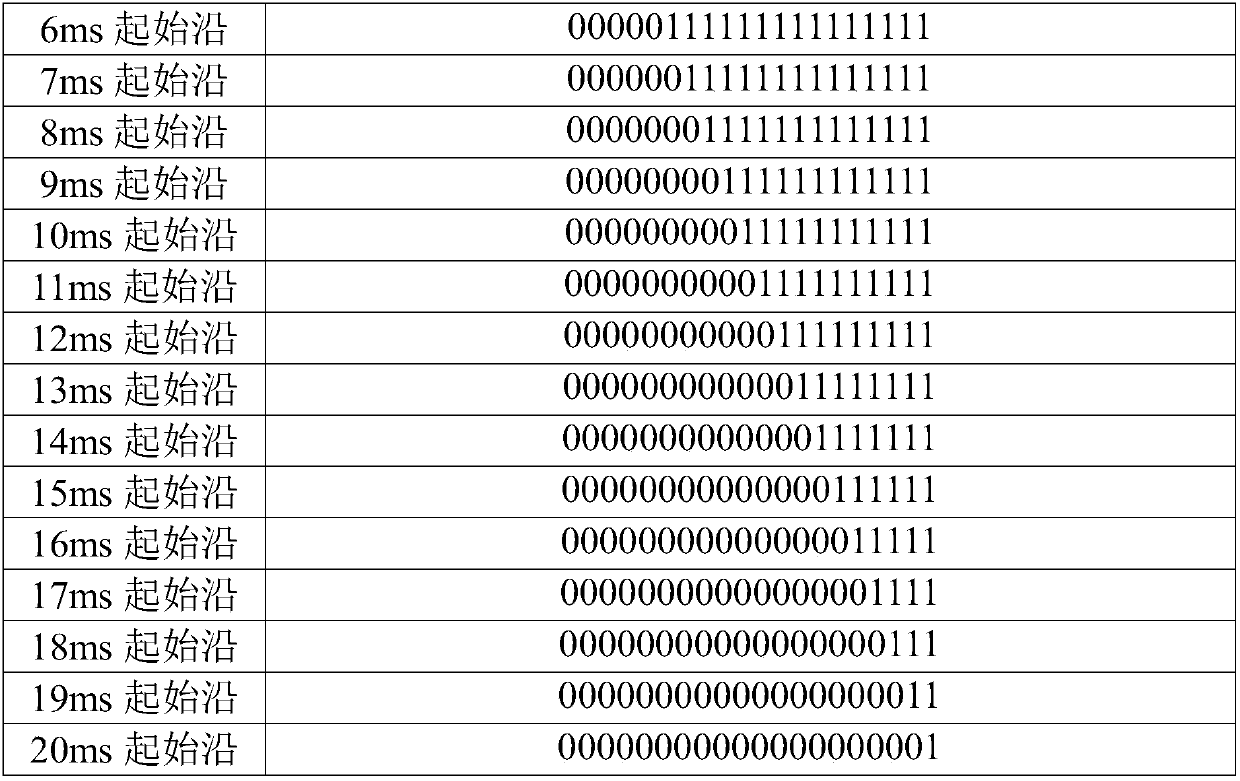
[0036] The principle of the present invention is: carry out N-way chip delay to the local code output by the tracking channel, generate N-way parallel code output, carry out correlation calculation between the N-way parallel code and the input baseband signal, and perform N-way parallel correlation results respectively N-way short-term accumulation, and finally delay the output of the N-way short-time accumulation results, and multiply it with the data jump coefficient read from the ROM, perform FFT transformation and take the modulus of the transformation result to compare the maximum value, and finally calculate the maximum value and the maximum value The value corresponds to the code phase and Doppler frequency latch. Method of the present invention specifically comprises the following steps:

[0037] Step 1: Generate channel local code, set carrier frequency

[0038] Adju...


PUM


Abstract

The invention discloses a high-sensitivity satellite navigation precise capture method. A common parallel correlation +FFT (discrete Fourier transformation fast algorithm) capture method is widely applied to satellite navigation. According to the method, a parallel correlation +FFT method which delays correlation result output is adopted. Through the method, registers which require latching of correlation values after multichannel correlation is completed can be greatly saved, so that occupied logical resources of an FPGA are reduced; and meanwhile, a special method is used for eliminating theinfluence of data bits (such as an NH code of BD2) of a part of satellite signals on correlation length, so that the length, correlated to pseudo-codes, of data is increased, and finally the purposeof improving precise capture sensitivity is achieved.

Description

technical field [0001] The invention belongs to a satellite navigation receiver signal processing method, in particular to a high-sensitivity satellite navigation fine capture method. Background technique [0002] Satellite navigation system (Beidou, GPS, GLONASS, etc.) is a high-precision navigation and positioning system. The satellite receiver receives the satellite signal through the receiving antenna and performs down-conversion processing on the satellite signal, and then performs baseband digital signal processing on the down-conversion signal. After the navigation solution processing, it can give accurate longitude, latitude, altitude, speed and time information. At present, satellite navigation is widely used in military and civilian fields. [0003] Baseband digital signal processing mainly includes functions such as capturing and tracking satellite signals. Due to the limitation of the algorithm, the acquisition sensitivity is generally much lower than the trac...

Claims


Application Information

Patent Timeline
Patent Type & Authority Applications(China)
IPC IPC(8): G01S19/24
CPCG01S19/24
Inventor 张燎祖秉法左启耀纪志农何子君吴婵娟
Owner BEIJING AUTOMATION CONTROL EQUIP INST
Why Eureka
Try Eureka