Concealed satellite navigation positioning system

A navigation positioning and positioning system technology, applied in the field of satellite navigation, can solve the problem that the satellite navigation system is easily identified and interfered, and achieve the effects of flexible star change, high spread spectrum gain, and strong anti-interference ability

Pending Publication Date: 2020-01-14
NAT ASTRONOMICAL OBSERVATORIES CHINESE ACAD OF SCI
View PDF0 Cites 8 Cited by
  • Summary
  • Abstract
  • Description
  • Claims
  • Application Information

AI Technical Summary

Problems solved by technology

[0005] In order to solve the problem that the satellite navigation system is easily identified and interfered, the object of the present invention is to provide a concealed satellite navigation and positioning system, which does not need to launch special navigation satellites, but hides the navigation signals on ordinary communication satellites , the navigation and positioning function is realized when the syst

Method used


Image

  • Concealed satellite navigation positioning system
  • Concealed satellite navigation positioning system
  • Concealed satellite navigation positioning system

Examples


Embodiment 1

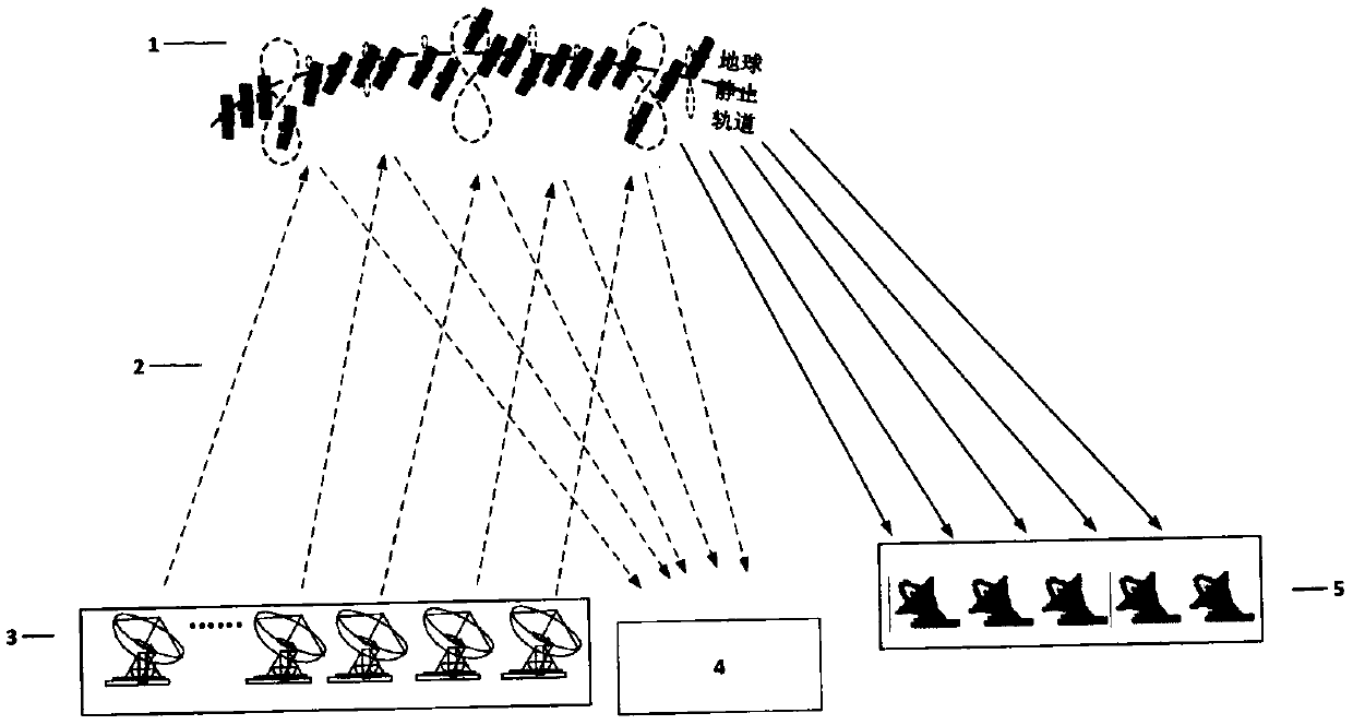
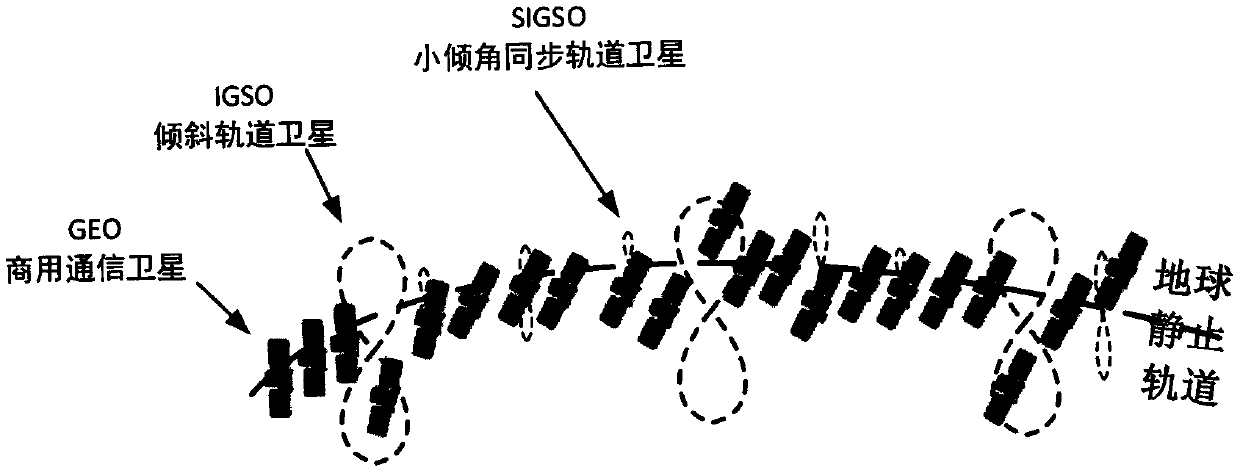
[0060] Adopt the above-mentioned covert satellite navigation and positioning system of the present invention, the frequency band is the C band, and its covert navigation and positioning master control station is 5 (4 masters and 1 standby) vehicle-mounted static communication stations, and the diameter of each vehicle-mounted antenna is 1.8 meters. The configured C Band power amplifier power is 25W. The covert navigation and positioning signal occupies one percent of the power of the satellite at full load. One of the Jingzhongtong vehicle stations is equipped with a high-precision atomic clock to generate the time of the navigation system, and is equipped with a high-precision time-frequency system, so that the time of the five navigation signal uplink stations can be synchronized and unified. The satellite constellation selects 5 of the C-band communication satellites within the visible range, of which there are 2 small-inclination orbit satellites with a DOP value of 50. T...

Embodiment 2

[0062] Adopt the above-mentioned covert satellite navigation and positioning system of the present invention, the frequency band is the Ku band, and its covert navigation and positioning main control station is 8 (7 masters and 1 standby) fixed ground stations, and each antenna aperture is 16 meters, and the power amplifier power of the Ku band of configuration for 20W. The covert navigation signal takes up 1 / 200th of the satellite's full load power. The concealed navigation and positioning master control station is equipped with a high-precision atomic clock to generate the time of the navigation system, and is equipped with a high-precision time-frequency distribution system, so that the time of the 8 navigation signal uplink stations can be synchronized and unified. The satellite constellation selects 8 of the Ku-band communication satellites within the visible range, including 2 SIGSO small-inclination inclined orbit satellites and 1 IGSO inclined orbit satellite, with a D...

Embodiment 3

[0064] Adopt the above-mentioned concealed satellite navigation and positioning system of the present invention, the frequency band is C band, and its concealed navigation and positioning master control station is 8 (7 masters and 1 standby) fixed ground stations, and each antenna aperture is 3.7 meters, and the C-band power amplifier power of configuration 200W. The covert navigation signal consumes 1 / 400th of the full power of the satellite. The concealed navigation and positioning master control station is equipped with a high-precision atomic clock to generate the time of the navigation system, and is equipped with a high-precision time and frequency system, so that the time of the 8 navigation signal uplink stations can be synchronized and unified. The satellite constellation selects 8 of the C-band communication satellites within the visible range, including 1 SIGSO small-inclination inclined orbit satellite and 1 IGSO inclined orbit satellite, with a DOP value of 20. T...


PUM


Abstract

A concealed satellite navigation and positioning system comprises a concealed satellite constellation, a concealed navigation and positioning signal, a concealed navigation and positioning ground master control station, an intelligent receiver and a passive orbit determination station. The concealed satellite constellation is a generic GEO communication satellite constellation and is composed of aC/Ku frequency band GEO commercial communication satellite, an SIGSO small-dip-angle synchronous orbit satellite and an IGSO inclined orbit satellite. The concealed navigation positioning signal is concealed under an original service signal of a generic GEO communication satellite, the signal power is less than one percent of the full-load power of a satellite transponder, the bandwidth of the navigation signal is more than 40MHz, and the signal-to-noise ratio reduction amplitude of the original signal does not exceed 0.3 dB; wherein the concealed navigation positioning ground master controlstation is a concealed navigation positioning fixed station which is fixedly arranged or a concealed navigation positioning vehicle-mounted communication-in-static station which can move along with avehicle; the intelligent receiver comprises an antenna module, a radio frequency module, a baseband processor module and an autonomous navigation module; the passive orbit determination station comprises at least four orbit determination reference stations located on the surface of the earth. The orbit determination base station receiver collects satellite signals, calculates the position correction amount of a measured satellite, counts the orbit determination precision, arranges the satellite position correction amount information into a navigation message, and injects the satellite positioncorrection amount information into the satellite through the concealed navigation positioning ground master control station for positioning by a user.

Description

technical field [0001] The invention belongs to the field of satellite navigation, in particular to a concealed satellite navigation and positioning system. Background technique [0002] The current satellite navigation technology is developed such as GPS in the United States, GLONASS in Russia, Galileo in Europe and Beidou Satellite Navigation System (BDS) in China. In addition to these four global navigation systems, many countries are developing their own regional positioning systems, including Japan's QZSS and India's IRNSS. The above-mentioned system is similar to GPS with minor differences, and there is no essential difference. The extremely powerful GPS is easily jammed. The satellite signal is attenuated by a path of nearly 20,000 kilometers, and the power reaching the ground is extremely weak (the order of magnitude is only 10-16 watts). In particular, GPS is allocated only three narrow and fixed L-bands in the International Telecommunication Union (ITU). During...

Claims


Application Information

Patent Timeline
IPC IPC(8): G01S19/42G01S19/21
CPCG01S19/21G01S19/421
Inventor 崔君霞艾国祥马利华庞峰胡超王兆瑞裴军马冠一吕昌胡正群
Owner NAT ASTRONOMICAL OBSERVATORIES CHINESE ACAD OF SCI
Why Eureka
Try Eureka