An electronic map generation system and method

An electronic map and generation system technology, applied in directions such as road network navigators, can solve problems such as hidden dangers of driving safety, inability to detect the traffic situation of the vehicle in time, and inability to locate which lane the vehicle belongs to, so as to prevent driving accidents and avoid violations. effect of driving

Active Publication Date: 2022-06-14
ZHEJIANG GEELY AUTOMOBILE RES INST CO LTD +1
View PDF6 Cites 0 Cited by
  • Summary
  • Abstract
  • Description
  • Claims
  • Application Information

AI Technical Summary

Problems solved by technology

[0003] At present, the commonly used positioning scheme on the car is to locate the vehicle by combining maps and real-time perception sensors such as front-view cameras, lidar and IMU installed on the vehicle. However, the current positioning scheme can only be aimed at single-lane, single-lane-based The information of the vehicle’s driving lane cannot be directly displayed for the environmental information next to the lane, and for multi-lane road conditions, the existing positioning scheme cannot locate which lane the vehicle belongs to, and at the same time cannot detect the traffic conditions outside the vehicle in time. Security poses hidden dangers

Method used


Image

  • An electronic map generation system and method
  • An electronic map generation system and method
  • An electronic map generation system and method

Examples


Embodiment

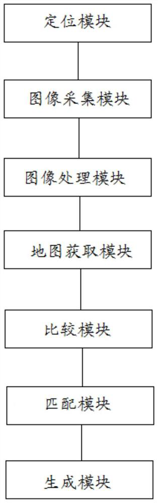
[0064] See Figure 1 , Figure 1 For the present invention electronic map generation system in one embodiment of a block diagram, e.g., Figure 1 As shown, the electronic map generation system, the system comprising a positioning module, an image acquisition module, an image processing module, a map acquisition module, a comparison module, a matching module, a generation module, a display module, an enclosure module, and a data transmission module.

[0065] The positioning module for determining the position of the main vehicle.

[0066] Among them, the positioning module is a receiver installed on the main vehicle, and the receiver receives multiple GNSS signals through the global navigation satellite system, so as to achieve rough positioning of the main vehicle and obtain the approximate position of the main vehicle. The approximate location includes the longitude and latitude of the main vehicle and the speed and direction of travel of the main vehicle.

[0067] The image acquisiti...


PUM


Abstract

The invention provides a system and method for generating an electronic map. The system includes a positioning module for determining the position of the host vehicle; an image acquisition module for collecting the surrounding environment of the host vehicle in real time; an image processing module for The surrounding environment of the vehicle identifies road static objects and road dynamic objects; the map acquisition module is used to obtain map information with multiple lanes; the comparison module is used to compare the identified road static objects with map information to determine the The target position; the matching module is used to determine the host vehicle on the target position of the map according to the position of the host vehicle, and obtains a multi-lane map containing the host vehicle; the generation module is used to fuse and identify the road static target, the road dynamic target and the host vehicle. A multi-lane map of a vehicle, generating a target map. The invention can accurately locate the host vehicle and monitor the traffic conditions outside the host vehicle.

Description

Technical field [0001] The present invention relates to the automotive field, in particular to an electronic map generation system and method. Background [0002] The car display instrument is an important window for the driver to exchange information with the car, and is an important guarantee for the safe driving of the car. With the development of automobiles to intelligent, networked, and electrified technologies, the amount of information required to be displayed by automotive instruments has gradually increased, which puts forward higher requirements for the interactivity, network sharing and accuracy of information and people. [0003] At present, the commonly used positioning scheme on the car is to combine the map and the front-view camera installed on the vehicle, lidar and IMU and other real-time perception sensors to locate the vehicle, however, the current positioning scheme can only be for a single lane, a single lane is the information of the driving lane of the ca...

Claims


Application Information

Patent Timeline
Patent Type & Authority Patents(China)
IPC IPC(8): G01C21/32
CPCG01C21/32
Inventor 傅湘国
Owner ZHEJIANG GEELY AUTOMOBILE RES INST CO LTD
Why Eureka
Try Eureka