Self-adaptive multi-source InSAR ground subsidence monitoring time series data splicing method and system

A land subsidence, time series technology, applied in geographic information database, database index, structured data retrieval, etc., to achieve the effect of improving data accuracy, reducing system error, and strong applicability

Active Publication Date: 2020-02-11
CAPITAL NORMAL UNIVERSITY
View PDF3 Cites 8 Cited by
  • Summary
  • Abstract
  • Description
  • Claims
  • Application Information

AI Technical Summary

Problems solved by technology

[0005] Based on the defects that the above-mentioned traditional methods cannot fully consider the above-mentioned three problems, the present invention will comprehensively con

Method used


Image

  • Self-adaptive multi-source InSAR ground subsidence monitoring time series data splicing method and system
  • Self-adaptive multi-source InSAR ground subsidence monitoring time series data splicing method and system
  • Self-adaptive multi-source InSAR ground subsidence monitoring time series data splicing method and system

Examples


Embodiment 1

[0046] Aiming at the three problems existing in the current multi-source InSAR deformation time series mosaic technology, the present invention proposes corresponding solutions and improves them from multiple angles, including:

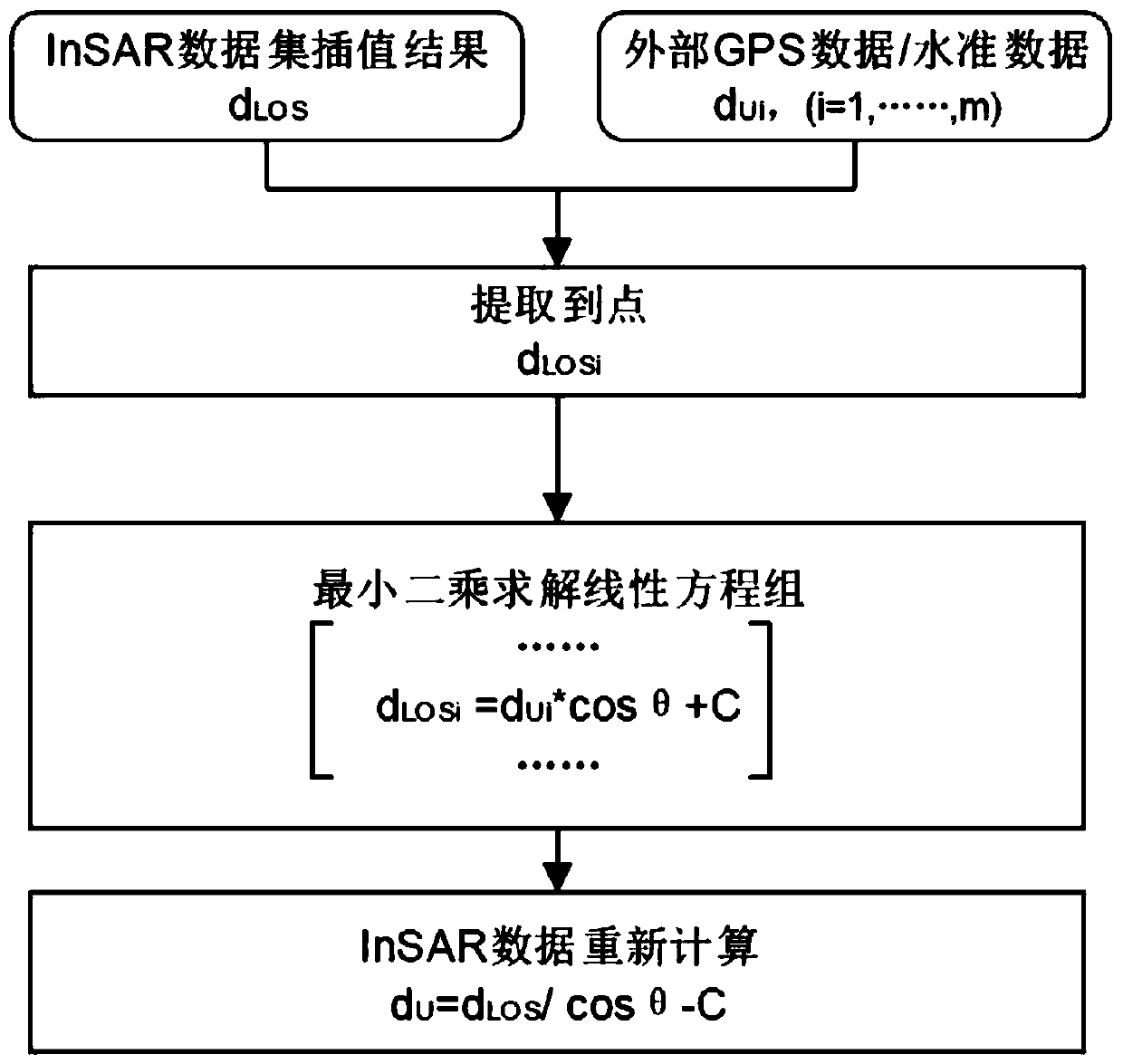
[0047] 1) Imaging geometry. Previous studies have directly ignored the influence of horizontal deformation. The present invention introduces external GPS or benchmark data to weaken the influence of horizontal deformation, and then accurately calculates vertical deformation.

[0048] 2) Spatial scope. Most of the previous studies used a certain data set as a reference, and there will be uneven coverage. The present invention unifies the data coverage by constructing a spatial grid, and weakens the influence of mutation points on the overall data through a resampling method, and at the same time ensures the spatial resolution.

[0049] 3) Spatial reference. None of the previous studies mentioned the issue of spatial reference. In fact, the selection...

Embodiment 2

[0090] In yet another specific embodiment, the present invention also proposes an adaptive multi-source InSAR monitoring land subsidence time series data mosaic system, which can perform, for example, the adaptive multi-source InSAR monitoring land subsidence described in Embodiment 1 Time series data stitching methods.

[0091] In a specific embodiment, the system can be implemented in the following ways:

[0092] The geometric correction module is used to perform multi-source InSAR imaging geometric correction based on the obtained satellite data, and in the geometric correction, only the vertical deformation is solved;

[0093] The resampling module is used to determine the common area of ​​multi-source InSAR monitoring results, constructs a spatial grid, resamples the InSAR data set after the geometric correction, and obtains a multi-source InSAR spatial grid data set;

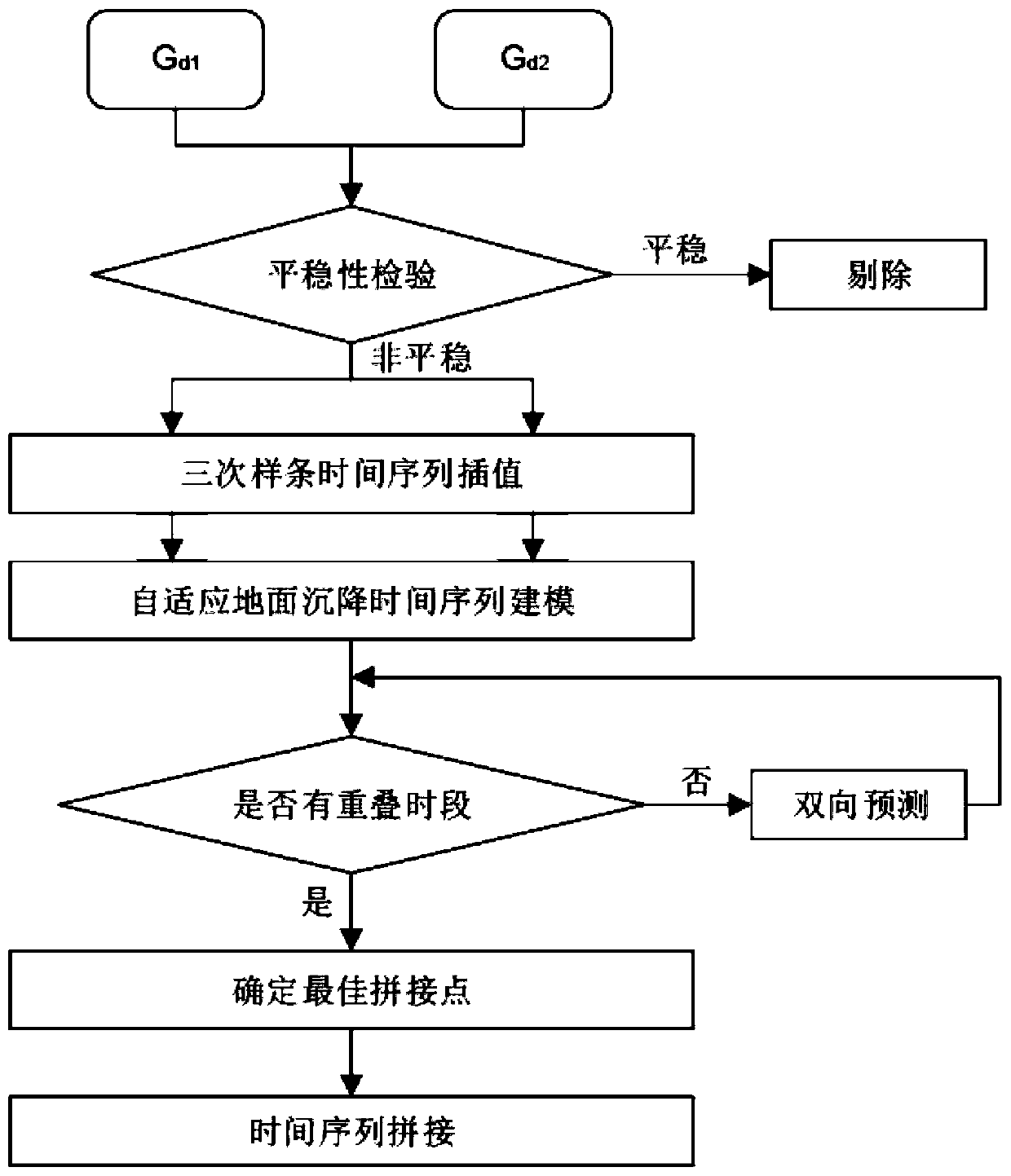
[0094] A reference point unification module is used to select a grid in the spatial grid whose deforma...


PUM


Abstract

The invention provides a self-adaptive multi-source InSAR ground subsidence monitoring time series data splicing method and system. According to the method, the problems in three aspects of imaging geometry, space coverage and time matching degree in land subsidence time sequence splicing are considered, and in the imaging geometry, the precision of an InSAR monitoring result is improved by estimating vertical deformation of InSAR data; a method for constructing a spatial grid is provided for different spatial coverage ranges and spatial resolutions of a multi-source InSAR data set; considering the difference of spatial references, the external data is proposed for the first time to unify the spatial references so as to reduce system errors; and a self-adaptive time sequence model is constructed by utilizing a thought of time sequence decomposition, so that the introduction of errors of a common fitting model is avoided, and the precision of spliced data is improved. According to the method, the applicability of large-scale splicing of the land subsidence time series data of the multi-source InSAR monitoring result is high, and the precision of the spliced data is obviously improved.

Description

technical field [0001] The invention relates to the field of land subsidence time series data processing, in particular to an adaptive mosaic method and system for land subsidence time series data of large-scale multi-source InSAR monitoring results. Background technique [0002] Land subsidence is an environmental geological phenomenon of loss of ground elevation caused by soil compression under the combined action of natural and human factors. It has the characteristics of irreparable permanent environment and resource loss. Development is very necessary. With the advancement of remote sensing technology, land subsidence monitoring technology has entered a new era. At present, Interferometric Synthetic Aperture Radar (InSAR) technology has high precision, large range, long time sequence, and high deformation sensitivity compared with conventional point and line observation monitoring methods such as leveling, layered markers, and GPS measurements. The advantages. Especi...

Claims


Application Information

Patent Timeline
IPC IPC(8): G06F16/21G06F16/22G06F16/2458G06F16/29
CPCG06F16/212G06F16/2291G06F16/2474G06F16/29
Inventor 陈蓓蓓宫辉力段利李小娟周超凡高明亮曹群
Owner CAPITAL NORMAL UNIVERSITY
Why Eureka
Try Eureka