GIM map-based GNSS receiver hardware delay rapid calculation method

A hardware delay and receiver technology, which is applied to satellite radio beacon positioning systems, measuring devices, instruments, etc., can solve the problems of low hardware delay accuracy and large errors of GNSS receivers, and achieve high timeliness and improved hardware The Effect of Latency Precision

Pending Publication Date: 2020-03-24
CHINA ELECTRONICS TECH GRP NO 7 RES INST
View PDF5 Cites 1 Cited by
  • Summary
  • Abstract
  • Description
  • Claims
  • Application Information

AI Technical Summary

Problems solved by technology

[0010] In order to solve the problem that the GNSS receiver hardware delay accuracy is not high and there is a large error in the prior art, the present invention provides a fast solution method for the GNSS receiver hardware delay based on the GIM map, which can effectively improve the accuracy of the GNSS receiver. Hardware Delay Accuracy

Method used


Image

  • GIM map-based GNSS receiver hardware delay rapid calculation method
  • GIM map-based GNSS receiver hardware delay rapid calculation method
  • GIM map-based GNSS receiver hardware delay rapid calculation method

Examples


Embodiment 1

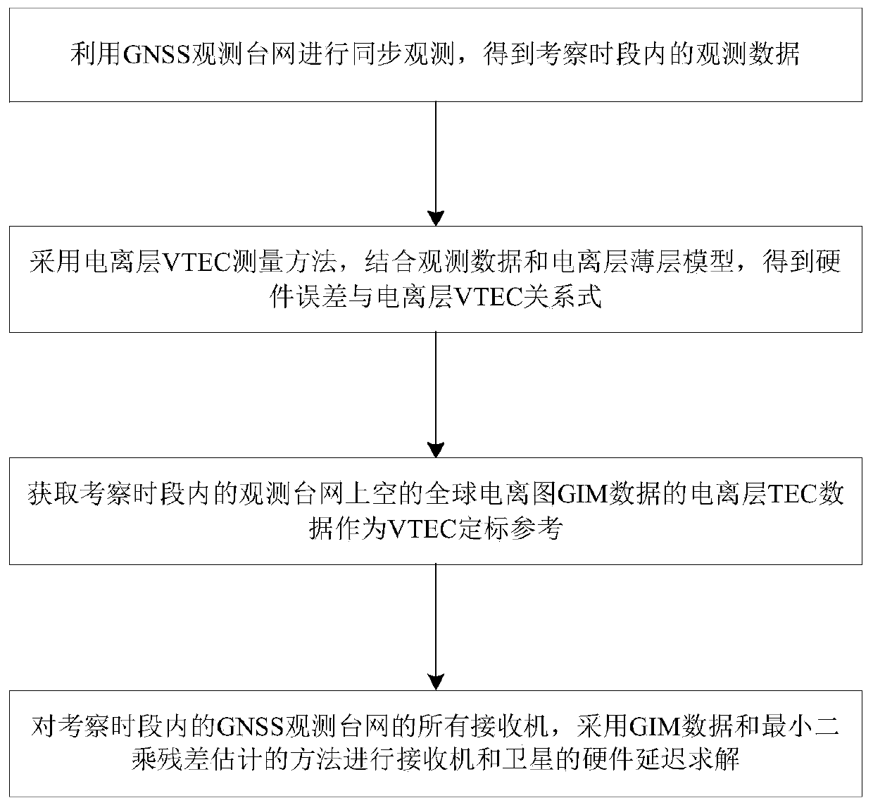
[0052] Such as figure 1 Shown, a kind of fast solution method of the GNSS receiver hardware delay based on GIM map, described this method comprises steps as follows:

[0053] S1: Use the GNSS observation network to conduct synchronous observations to obtain observation data during the investigation period;

[0054] Wherein, the observation data includes the geographic location latitude φ of the GPS observation station 0 , longitude λ 0 , and the elevation angle E at the time of observation 0 and azimuth AZ.

[0055] S2: Using the ionospheric vertical TEC measurement method, combined with the observation data and the ionospheric thin layer model, the relationship between the hardware error and the ionospheric VTEC is obtained;

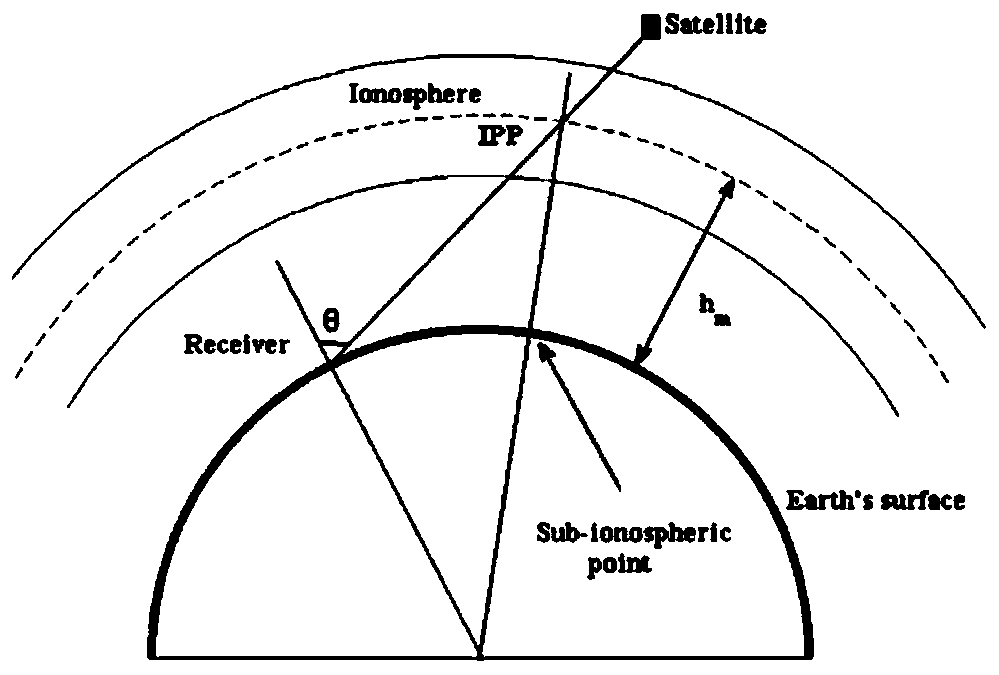
[0056] Wherein, the ionospheric thin layer model is to regard the charged particles of the ionosphere as concentrated in a thin shell concentric with the earth, and its typical height is 350-450 km, such as figure 2 shown.

[0057] According to t...


PUM


Abstract

The invention discloses a GIM map-based GNSS (Global Navigation Satellite System) receiver hardware delay rapid calculation method, which comprises the following steps of: carrying out synchronous observation by utilizing a GNSS observation station network to obtain observation data in an investigation time period; obtaining a relational expression between the hardware error and the ionized layerVTEC by adopting an ionized layer VTEC measurement method and combining the observation data and the ionized layer thin layer model; obtaining ionized layer TEC data of global ionogram GIM data over the observation station network in the investigation time period as VTEC calibration reference; for all receivers of a GNSS observation station network in an inspection time period, solving hardware delay of the receiver and the satellite by adopting a GIM data and least square residual estimation method; calculating a receiver hardware delay error DCB and a vertical TEC over the station by using the VTEC obtained in the steps S2 and S3 through a least square method, and performing additional constraint by adopting an average value of daily ionized layer delay residual errors when the receiverdelay error is calculated.

Description

technical field [0001] The present invention relates to the technical field of satellite navigation system receivers, and more specifically, to a fast solution method for hardware delay of a GNSS receiver based on a GIM map. Background technique [0002] As one of the important parameters of the ionosphere, the ionospheric TEC has been widely used in the fields of ionospheric research and satellite navigation. The use of GNSS satellites to obtain ionospheric TEC has the characteristics of convenience, high measurement accuracy, and good temporal and spatial continuity. It has always been one of the main measurement methods for ionospheric TEC. very important practical significance. [0003] In the measurement of GNSS TEC, there are many aspects that may cause errors, such as multipath, cycle slip, tropospheric delay, etc., and one of the important error sources is the hardware delay error. It is the hardware deviation caused by the fact that the hardware channels of the GP...

Claims


Application Information

Patent Timeline
Patent Type & Authority Applications(China)
IPC IPC(8): G01S19/25G01S19/23
CPCG01S19/25G01S19/235
Inventor 彭伟余涛刘彦明赵华武建兵王青伟齐巍夏淳亮李顶伦李沃若郭军
Owner CHINA ELECTRONICS TECH GRP NO 7 RES INST
Why Eureka
Try Eureka