Landform type division method based on ArcGIS

A type classification and landform technology, applied in geographic information databases, special data processing applications, structured data retrieval, etc., can solve problems such as difficult scientific, accurate, comprehensive, systematic division, time-consuming and labor-intensive, and achieve system unification, Quantitatively accurate effects

Pending Publication Date: 2020-03-31
YUNNAN HANZHE TECHN CO LTD
View PDF4 Cites 5 Cited by
  • Summary
  • Abstract
  • Description
  • Claims
  • Application Information

AI Technical Summary

Problems solved by technology

The traditional landform classification mainly adopts the method of topographic map measurement combined with field survey, which is not only time-consuming and laborious, but also difficult to divide scientifically, accurately, comprehensively and systematically

Method used


Image

  • Landform type division method based on ArcGIS
  • Landform type division method based on ArcGIS
  • Landform type division method based on ArcGIS

Examples


Embodiment Construction

[0027] In order to make the object, technical solution and advantages of the present invention more clear, the present invention will be further described in detail below in conjunction with the examples. It should be understood that the specific embodiments described here are only used to explain the present invention, not to limit the present invention.

[0028] The application principle of the present invention will be described in detail below in conjunction with the accompanying drawings.

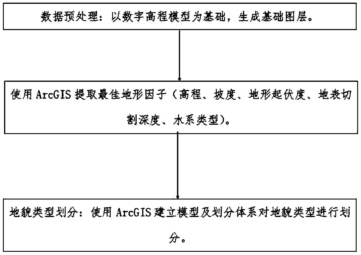
[0029] A method for classifying landform types based on ArcGIS includes the following steps:

[0030] Step 1: Data preprocessing: Based on the digital elevation model, a basic layer is generated;

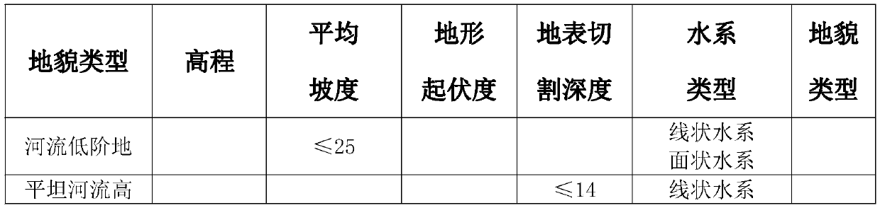
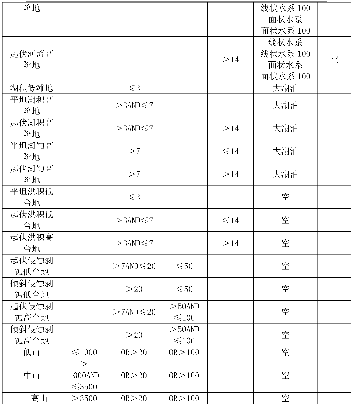
[0031] Step 2: Extract terrain factors: use ArcGIS to extract the best terrain factors;

[0032] Step 3: Classification of landform types: Use ArcGIS to establish a model and a classification system to classify landform types.

[0033] Further, the data preprocessing: based on the digital...


PUM


Abstract

The invention discloses an ArcGIS-based geomorphic type division method, which is used for dividing geomorphic types by establishing a model and a division system in ArcGIS, and comprises the following steps of: data preprocessing: generating a basic map layer on the basis of a digital elevation model; terrain factor extraction: extracting an optimal terrain factor by using ArcGIS; geomorphic typedivision: using ArcGIS to establish a model and a division system to divide geomorphic types. According to the invention, a digital elevation model (DEM) is used in ArcGIS and a spatial analysis processing function is applied to carry out automatic discrimination and division of landform types; according to the method, topographic factors (elevation, gradient, topographic relief, earth surface cutting depth and the like) are extracted mainly based on a specification statistical unit, then multiple topographic factors are comprehensively analyzed, time and labor are saved, and standard consistency, system unification and quantification accuracy can be achieved.

Description

technical field [0001] The invention relates to the technical field of landform type classification, in particular to an ArcGIS-based landform type classification method. Background technique [0002] The earth's surface space is the environmental basis for the survival of all living things in nature, as well as the basic place and material basis for human activities. It is not a flat horizontal surface, but a space of various shapes, sizes, and heights. The planar space composed of surface shapes, these shapes with different sizes and shapes, and different undulating heights are collectively called terrain or landform. Geomorphology is a basic factor in the ground space environment. People often encounter some problems related to geomorphology knowledge in daily life or in social and economic production, such as how to rationally use land and build farmland water conservancy in agricultural production. Engineering, soil erosion prevention and soil and water conservation re...

Claims


Application Information

Patent Timeline
Patent Type & Authority Applications(China)
IPC IPC(8): G06F16/29
CPCG06F16/29
Inventor 王琳邓昌军傅南昌赵明瑞罗元金李锐
Owner YUNNAN HANZHE TECHN CO LTD
Why Eureka
Try Eureka