Flood dynamic assessment method, device, medium and equipment based on reality model
A real-world model and dynamic assessment technology, applied in instrumentation, climate change adaptation, data processing applications, etc., can solve problems such as insufficient refinement and accuracy, limited accuracy of assessment results, and lack of time-based dynamic results data.
- Summary
- Abstract
- Description
- Claims
- Application Information
AI Technical Summary
Problems solved by technology
Method used
Image
Examples
Embodiment
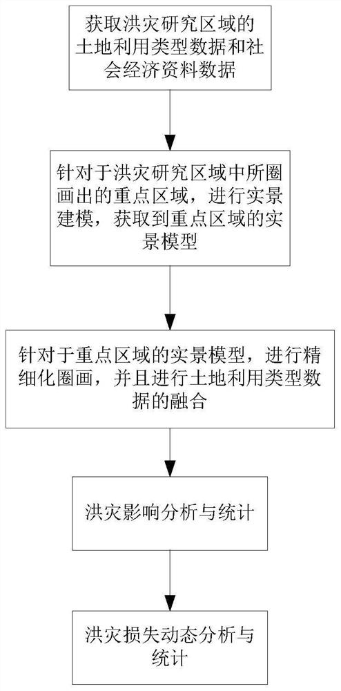
[0102] This embodiment discloses a flood dynamic assessment method based on a real-scene model. After flood simulation is performed on the corresponding area of the real-scene modeling, the method of this embodiment can perform a dynamic assessment of the flood in this area; figure 1 As shown, the specific process of the method is as follows:
[0103] Step S1, for a specific engineering research area, that is, a flood disaster research area, to obtain land use type data and socio-economic data of the research area.
[0104] In this embodiment, the land use type includes cultivated land, grassland, water area and urban and rural land, and when the type is urban and rural land, it is divided into industrial land and residential land.
[0105] Socioeconomic data include regional population, GDP, road data, resident property, agricultural output value, industrial output value and service industry output value.
[0106] For example, take a certain county A as the flood disaster ...
Embodiment 2
[0190] This embodiment discloses a real-scene model-based flood dynamic assessment device, which includes:
[0191] The data acquisition module is used to obtain land use type data and socio-economic data of the research area for a specific engineering research area;
[0192] The real scene modeling module is used to carry out real scene modeling for the key areas circled in the research area, and obtain the real scene models of the key areas;
[0193] The data fusion module is used to refine the classification and circle drawing of the land use type data for the real scene model of the key area, and then compare the refined land use type data with the originally obtained land use type data of the key area Fusion;
[0194] Flood disaster impact analysis and statistics module, which is used to integrate the land use type data of the key area, access the flood simulation results in different periods, and combine the population, GDP and road data in the social data collected for...
Embodiment 3
[0198] This embodiment discloses a storage medium, which stores a program, and when the program is executed by a processor, the real-scene model-based flood dynamic assessment method described in Embodiment 1 is implemented, as follows:
[0199] For the flood disaster research area, obtain the land use type data and socio-economic data of the research area;
[0200] Carry out real scene modeling for the key areas circled in the flood disaster research area, and obtain the real scene model of the key areas;
[0201] For the real scene model of the key area, the refined classification and circle drawing of the land use type data are carried out, and then the refined land use type data is fused with the originally acquired land use type data of the key area;
[0202] Based on the fused data of land use types in key areas, access flood simulation results in different time periods, and combine population, GDP and road data in the social data collected for this key area to analyze a...
PUM
 Abstract
Description
Claims
Application Information
 - R&D
- Intellectual Property
- Life Sciences
- Materials
- Tech Scout
- Unparalleled Data Quality
- Higher Quality Content
- 60% Fewer Hallucinations
Browse by: Latest US Patents, China's latest patents, Technical Efficacy Thesaurus, Application Domain, Technology Topic, Popular Technical Reports.
© 2025 PatSnap. All rights reserved.Legal|Privacy policy|Modern Slavery Act Transparency Statement|Sitemap|About US| Contact US: help@patsnap.com


