Impulse interference detection and parameter determination method for satellite navigation receiver

A technology of pulse jamming and satellite navigation, applied in the field of radio satellite navigation, to achieve the effect of reducing impact, improving convenience, improving flexibility and parameterization ability

Active Publication Date: 2020-04-10
BEIJING RES INST OF TELEMETRY +1
View PDF27 Cites 4 Cited by
  • Summary
  • Abstract
  • Description
  • Claims
  • Application Information

AI Technical Summary

Problems solved by technology

However, none of the above-mentioned patents considers from the perspective of data processing of pulse interference detection and parameter determination.

Method used


Image

  • Impulse interference detection and parameter determination method for satellite navigation receiver
  • Impulse interference detection and parameter determination method for satellite navigation receiver
  • Impulse interference detection and parameter determination method for satellite navigation receiver

Examples


Embodiment 1

[0060] A satellite navigation receiver pulse interference detection and parameter determination method, comprising the following steps:

[0061] 1) Centralized analysis of civil navigation signals and divided into two frequency bands

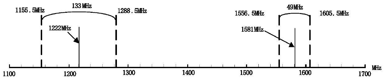
[0062] According to the frequency points and modulation methods of all navigation signals in Table 1, it can be known that all existing satellite navigation systems occupy a bandwidth of 449.95MHz in the L frequency band, such as figure 1 As shown, for the convenience of the subsequent signal processing part of the navigation receiver, the adjacent navigation signals are divided into one frequency band as much as possible, and then all the navigation signals are divided into two relatively concentrated frequency bands. The specific division method is as follows:

[0063] The first section is a navigation signal centered on 1.2G, specifically covering 1155.99MHz to 1288.75MHz, with a bandwidth of about 133MHz, including B2a, B2b, B3C, B3A, B3I, B...


PUM


Abstract

The invention provides an impulse interference monitoring and parameter determination method suitable for a navigation receiver. The satellite navigation receiver pulse interference detection method mainly adopts technologies of intercepting digital sampling data in a segmented manner, improving impulse interference detection capability through incoherent accumulation and the like, involves a received signal storage module, a data preprocessing module, a data smoothing module, a parameter determination module and the like, and completes impulse interference detection and parameter determination of a satellite navigation receiver through each module under unified clock control. According to the method, impulse interference entering the receiver can be rapidly detected and parameters can berapidly determined, pulse period and duty ratio parameters of impulse interference signals are given, interference alarm information is sent, and correctness and usability of the navigation receiver are improved under complex impulse interference conditions.

Description

technical field [0001] The invention relates to a pulse interference detection and parameter determination method of a satellite navigation receiver, belonging to the technical field of radio satellite navigation. Background technique [0002] Since the 1950s, satellite navigation technology has developed rapidly. In the last century, the GPS system of the United States and the GLONASS system of Russia have been completed. The European Union's satellite navigation system (GALILEO plan) officially started construction in March 2002, and is now basically completed and begins to provide some service capabilities. At the end of the last century, my country built the "Beidou-1" regional satellite navigation system, providing regional active positioning and navigation services for the Asia-Pacific region. In 2017, the "Beidou-2" satellite navigation system with higher performance and wider coverage was successfully built. According to the plan, the "Beidou-3" satellite navigatio...

Claims


Application Information

Patent Timeline
Patent Type & Authority Applications(China)
IPC IPC(8): G01S19/21G01S19/37
CPCG01S19/21G01S19/37
Inventor 张平胡彩亮艾伦封丽芳李斌
Owner BEIJING RES INST OF TELEMETRY
Why Eureka
Try Eureka