Post-earthquake building damage detection method based on unmanned aerial vehicle video

A detection method and building technology, applied in computer parts, three-dimensional object recognition, instruments, etc., can solve the problems of limited and difficult remote sensing data, and achieve good extraction effect

Active Publication Date: 2020-05-08
WUHAN UNIV
View PDF6 Cites 6 Cited by
  • Summary
  • Abstract
  • Description
  • Claims
  • Application Information

AI Technical Summary

Problems solved by technology

On the one hand, similar to airborne images, this method is limited by factors such as the shooting height and the terrain of the disaster area, and inevitably has defects such as occlusion of ground objects and dead angles of photography; on the other hand, pre-disaster/post-disast

Method used


Image

  • Post-earthquake building damage detection method based on unmanned aerial vehicle video
  • Post-earthquake building damage detection method based on unmanned aerial vehicle video
  • Post-earthquake building damage detection method based on unmanned aerial vehicle video

Examples


Embodiment Construction

[0062] The technical solution of the present invention will be described in detail below in conjunction with the accompanying drawings and embodiments, so as to make the technical content clearer and easier to understand. It should be noted that the protection scope of the present invention is not limited to the embodiments mentioned herein.

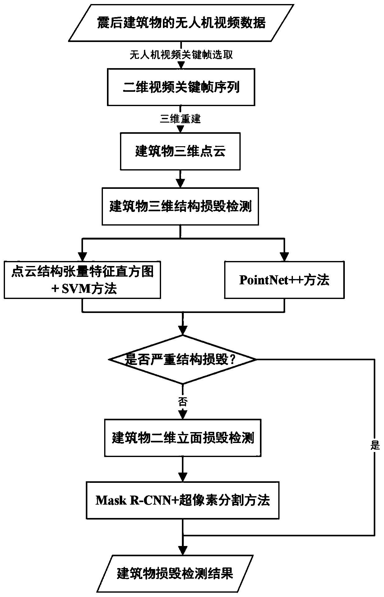
[0063] Such as figure 1 , the embodiment includes the following steps:

[0064] Step 1: Preprocessing the collected post-earthquake UAV video data and acquiring two-dimensional key frames.

[0065] The embodiment selects a two-dimensional key frame sequence based on unmanned aerial vehicle video data, and adopts the following steps frame by frame:

[0066] (1.1) Perform the following ambiguity analysis on the video frame by frame:

[0067] 1.1a) Convert video frames to grayscale images;

[0068] 1.1b) Calculate the Laplacian variance of the grayscale image: 1) First use the Laplacian operator (LoG, Laplacian of Gaussian) to detect th...


PUM


Abstract

The invention provides a post-earthquake building damage detection method based on an unmanned aerial vehicle video, and the method comprises the steps: step 1, carrying out preprocessing of collectedpost-earthquake unmanned aerial vehicle video data, and obtaining a video key frame sequence; step 2, generating building three-dimensional point cloud data by utilizing the video key frame sequence,performing building structure damage detection on the three-dimensional point cloud data by adopting a method based on point cloud structure feature analysis and deep learning feature analysis, and if the detected result is structure damage, entering step 4; if detecting that the structure is not damaged, executing the third step; step 3, obtaining a two-dimensional key frame image of a to-be-detected building, carrying out building facade damage detection by adopting a method based on deep learning feature analysis, then carrying out super-pixel segmentation on a two-dimensional key frame image of a to-be-detected building, and carrying out fusion post-processing optimization on an obtained building facade damage detection result by utilizing a super-pixel segmentation result; and 4, outputting a damage detection result of the to-be-detected building.

Description

technical field [0001] The present invention relates to the field of remote sensing application technology and the field of disaster assessment, in particular to the post-earthquake building damage detection technology based on unmanned aerial vehicle video, in particular to video key frame selection based on ambiguity and overlap analysis, and building damage detection technology based on computer vision technology. 3D point cloud reconstruction, building structural damage detection based on 3D point cloud deep learning and structural feature analysis, and building facade damage detection based on 2D key frame image deep learning and superpixel segmentation algorithm. Background technique [0002] After the earthquake, accurate acquisition of building damage information at the first time can provide important technical support and decision-making basis for emergency rescue, decision-making command, and post-earthquake reconstruction. Traditional satellite remote sensing ima...

Claims


Application Information

Patent Timeline
IPC IPC(8): G06K9/00G06K9/46G06K9/62
CPCG06V20/64G06V20/176G06V10/44G06V10/462G06F18/22G06F18/214
Inventor 眭海刚孙向东黄立洪刘超贤
Owner WUHAN UNIV
Why Eureka
Try Eureka