Unlock instant, AI-driven research and patent intelligence for your innovation.

UNET network-based multi-source perception fusion remote sensing image segmentation method and application

A remote sensing image and source sensing technology, applied in the field of multi-source fusion sensing remote sensing detection, can solve the problems of large workload, difficult robustness, complex remote sensing equipment environment, etc., and achieve the effect of high measurement accuracy

Pending Publication Date: 2020-05-22
AEROSPACE TIMES FEIHONG TECH CO LTD +1
View PDF5 Cites 2 Cited by
  • Summary
  • Abstract
  • Description
  • Claims
  • Application Information

AI Technical Summary

Problems solved by technology

[0005] 1) The remote sensing equipment is located in a complex environment, which is easily disturbed by external factors such as atmosphere, temperature and isobaric surface;
[0006] 2) For different geological and ecological environments, as well as the significant differences between different monitoring targets, it is difficult to obtain robust results in different remote sensing scenarios by the above method;
[0007] 3) If the target to be segmented in the remote sensing detection image changes, it is necessary to manually select new segmented target features, and manually labeling features requires a large workload;
[0008] 4) The remote sensing data obtained by multiple sensors cannot be processed uniformly

Method used


Image

  • UNET network-based multi-source perception fusion remote sensing image segmentation method and application
  • UNET network-based multi-source perception fusion remote sensing image segmentation method and application

Examples


Embodiment 1

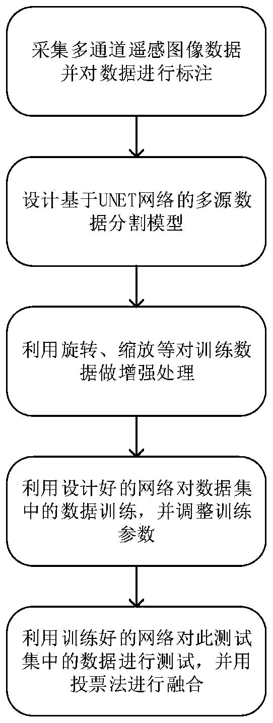
[0051] The UNET network-based multi-source perception fusion remote sensing image segmentation method and its application described in the present invention are based on the most commonly used convolutional neural network structure in artificial intelligence to study the remote sensing image segmentation. The present invention will study how to design a more suitable deep neural network structure to improve its accuracy in remote sensing image segmentation; aim at the shortcomings of the segmentation network model in remote sensing image segmentation, improve the loss function and training methods of the segmentation network, and improve the accuracy of remote sensing image segmentation. Split performance.

[0052] The present invention first constructs the high-resolution satellite image that contains 25 areas of 1 square kilometer in size, and the specific task is to identify 10 different types of objects through algorithms, which are respectively: 1. houses and buildings; 2....


PUM


Abstract

The invention provides a UNET network-based multi-source perception fusion remote sensing image segmentation method and application. The segmentation method uses the same deep neural network model toperform fusion processing on multi-source remote sensing image information, and remote sensing data of multiple channels is effectively utilized. The target can be automatically segmented after labeling and network training without manually designing characteristics of the required segmentation categories. Meanwhile, segmentation results of different segmentation targets can be automatically fused. The segmentation result can be quickly obtained through GPU acceleration operation. Meanwhile, the segmentation method is applied to the field of unmanned aerial vehicles, so that the accuracy of various sensor characteristics of the unmanned aerial vehicles can be further improved, and the flight height of the unmanned aerial vehicles can be more accurately obtained.

Description

【Technical field】 [0001] The invention relates to the technical field of multi-source fusion sensing remote sensing detection, in particular to a UNET network-based multi-source sensing fusion remote sensing image segmentation method and application. 【Background technique】 [0002] Traditional remote sensing data analysis relies heavily on manpower and some simple statistical image processing methods. With the development of artificial intelligence and other related fields in recent years, the analysis of remote sensing data also uses artificial intelligence methods in large numbers. Using the advantages of artificial intelligence to process and analyze data can improve the intelligence and automation of remote sensing data analysis, and improve the accuracy and efficiency of analysis. This topic intends to construct a remote sensing image segmentation dataset and realize an automatic remote sensing image segmentation method based on a deep neural network. The dataset is us...

Claims


Application Information

Patent Timeline
IPC IPC(8): G06T7/10
CPCG06T7/10G06T2207/10032G06T2207/20081G06T2207/20084G06T2207/20221
Inventor 姜梁马祥森吴国强黄坤李晓明
Owner AEROSPACE TIMES FEIHONG TECH CO LTD