Automatic ship route planning and evaluating method based on marine environment map layer

A marine environment and evaluation method technology, applied in the field of maritime transportation and shipping, can solve the problems of insufficient comprehensive factors affecting navigation, low degree of automation, refined optimization and evaluation of marine environmental information, etc., to reduce complex manual labor, reduce The effect of computation

Active Publication Date: 2020-06-02
THE 724TH RES INST OF CHINA SHIPBUILDING IND
View PDF5 Cites 4 Cited by
  • Summary
  • Abstract
  • Description
  • Claims
  • Application Information

AI Technical Summary

Problems solved by technology

However, this kind of route customization method is relatively rough and the degree of automation is not high, so it is difficult to meet the needs of modern shipping.
With the development of modern computing technology, the research on automatic route planning methods is increasing and becoming mainstream, based on A* algorithm, Dijkstra algorithm, binary tree algorithm, genetic algorithm, ant colony algorithm, simulated a

Method used


Image

  • Automatic ship route planning and evaluating method based on marine environment map layer
  • Automatic ship route planning and evaluating method based on marine environment map layer
  • Automatic ship route planning and evaluating method based on marine environment map layer

Examples


Embodiment Construction

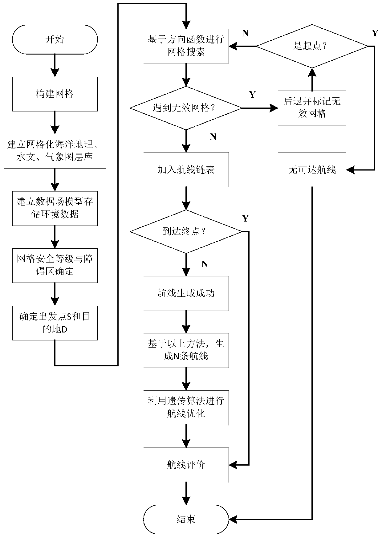
[0021] The concrete implementation method of the present invention is:

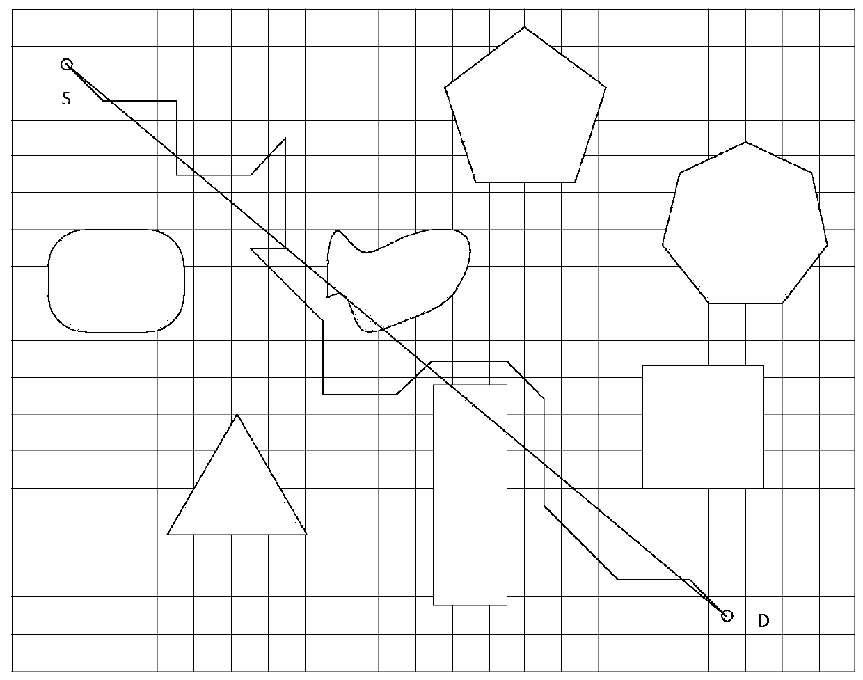
[0022] Step 1 extracts marine environmental information, builds a gridded marine geography, hydrology, and meteorological layer library, supports layer overlay, and the grid side length is d, which can be dynamically adjusted according to the sea area environment and route planning requirements.

[0023] (1) Geographic layer: when the value of the grid vertex is negative, it represents the water depth, and when it is positive, it is the altitude of the island and reef obstacles.

[0024] (2) Hydrological layer: (a) large-scale ocean current information, (b) wave current field prediction data, (c) sea ice data; (d) temperature, humidity, pressure and other data.

[0025] (3) Meteorological layer: (a) monsoon information; (b) sea fog information; (c) severe weather information such as tornado.

[0026] Step 2 establishes the data field model of the environmental object U:

[0027] U=g(x,y,z,t,id,layer)
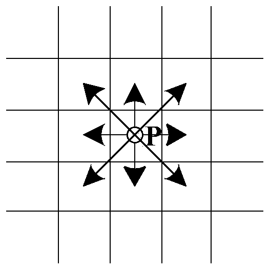
...


PUM


Abstract

The invention discloses an automatic ship route planning and evaluating method based on a marine environment map layer. According to the method, marine environment information and ship characteristicsare integrated for route planning, firstly, the marine environment information is extracted, a gridding marine geography, hydrology and meteorology layer library and a data field model are constructed, and effective reorganization and storage of environmental data are completed; determining a grid safety level and a navigation impeding area according to ship parameters and safety navigation requirements; designing a direction function, proposing automatic grid search based on the direction function, realizing automatic route planning and generation, and performing route optimization by usinga genetic algorithm method; and finally, constructing three index models such as an air route voyage, an air route risk degree and navigation energy consumption to perform air route evaluation, and giving an air route efficiency value. According to the method, the automatic ship route planning, generating, optimizing and evaluating capacity in the complex marine environment can be effectively improved, the navigation efficiency is improved, the navigation risk is reduced, and technical support can be provided for a new generation of intelligent ships and unmanned ships.

Description

technical field [0001] The invention relates to the field of ship route planning and is applicable to marine traffic and shipping. Background technique [0002] my country is a large maritime country and also a "world factory". With the continuous implementation and deepening of the strategy of a maritime power, the growth of the world economy and the development of trade, the development of shipping has become increasingly prosperous. With the rapid development of the maritime transportation industry, the number of ships is constantly increasing. The maritime transportation environment is complex and diverse. Sea wind, waves, currents and obstacles will directly or indirectly affect the safe navigation of ships, and even cause a series of traffic safety and navigation efficiency. and other issues directly affect the operating efficiency of shipping. Facing the increasingly fierce shipping competition situation, the requirements for efficient, safe and controllable completi...

Claims


Application Information

Patent Timeline
IPC IPC(8): G06Q10/04G06Q10/06G06Q50/30G06N3/12
CPCG06Q10/047G06Q10/06393G06Q50/30G06N3/126Y02A90/10
Inventor 鲍鹏飞安振宇崔威威李栋
Owner THE 724TH RES INST OF CHINA SHIPBUILDING IND
Why Eureka
Try Eureka