True three-dimensional aerial remote sensing geological interpretation method and system in engineering geological investigation

A technology of engineering geology and aerial remote sensing, which is applied in the field of remote sensing geological interpretation, can solve problems such as constraints on the utilization of aerial remote sensing images, cumbersome translation of interpretation results, and difficulty in positioning and finding interpretation target images

Pending Publication Date: 2020-06-05
CHANGCHUN INST OF TECH
View PDF6 Cites 5 Cited by
  • Summary
  • Abstract
  • Description
  • Claims
  • Application Information

AI Technical Summary

Problems solved by technology

[0005] (1) The construction model in the process of true 3D aerial remote sensing geological interpretation in the existing engineering geological survey is incomplete; at the same time, the storage is redundant and the efficiency of data extraction is low
[0006] (2) Most of the exi

Method used


Image

  • True three-dimensional aerial remote sensing geological interpretation method and system in engineering geological investigation
  • True three-dimensional aerial remote sensing geological interpretation method and system in engineering geological investigation

Examples


Embodiment 1

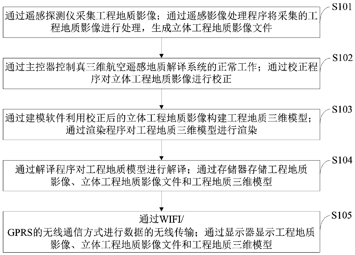
[0105] The true three-dimensional aerial remote sensing geological interpretation method in the engineering geological survey provided by the embodiment of the present invention is as follows: figure 1 As shown, as a preferred embodiment, the method of processing the collected engineering geological image through the remote sensing image processing program provided by the embodiment of the present invention to generate a three-dimensional engineering geological image file includes:

[0106] (1) analyzing the video file to obtain a plurality of image frames of the video file, and selecting a reference image frame among the plurality of image frames;

[0107] (II) determining a foreground area and a background area of ​​an image frame after the reference image frame according to the reference image frame;

[0108] (III) performing image processing on the foreground area and the background area respectively to obtain a foreground image and a background image;

[0109] (IV) combi...

Embodiment 2

[0117] The true three-dimensional aerial remote sensing geological interpretation method in the engineering geological survey provided by the embodiment of the present invention is as follows: figure 1 As shown, as a preferred embodiment, the construction method of the engineering geological three-dimensional model provided by the embodiment of the present invention specifically includes:

[0118] (1) Perform feature extraction on the corrected three-dimensional engineering geological image through a feature extraction program, and generate feature data;

[0119] (2) Analyze, import and generate point sets for feature data through data processing programs

[0120] If there is a measurement original data point file, the file can be imported into GOCAD in text format; when there is no measurement original data point file, the contour line can be extracted from the topographic map, and the AUTOCAD drawing can be saved in DXF format and imported as a DXF file GOCAD;

[0121] (2)...

Embodiment 3

[0143] The true three-dimensional aerial remote sensing geological interpretation method in the engineering geological survey provided by the embodiment of the present invention is as follows: figure 1 As shown, as a preferred embodiment, the method for storing engineering geological images, three-dimensional engineering geological image files and engineering geological three-dimensional models through memory provided by the embodiments of the present invention is as follows:

[0144] 1) Obtain remote sensing images through remote sensing detectors;

[0145] 2) Extending the remote sensing image to the edge of the L-th level grid adjacent to the edge of the remote sensing image, and filling the extended part with invalid values ​​to generate an updated remote sensing image; the L-th level grid is The maximum grid level corresponding to the remote sensing image determined according to the resolution; L is a positive integer;

[0146] 3) Segmenting the updated remote sensing im...


PUM


Abstract

The invention belongs to the technical field of remote sensing geological interpretation, and discloses a true three-dimensional aerial remote sensing geological interpretation method and system in engineering geological investigation, the true three-dimensional aerial remote sensing geological interpretation method in engineering geological investigation comprises the following steps: collectingand processing an engineering geological image to generate a three-dimensional engineering geological image file; correcting the three-dimensional engineering geological image, constructing an engineering geological three-dimensional model, and rendering and interpreting the engineering geological three-dimensional model; and storing and displaying the engineering geological image, the three-dimensional engineering geological image file and the engineering geological three-dimensional model. Fitting and interpolation are carried out according to discrete geological prospecting data, a three-dimensional geological model of information such as terrain, stratum boundaries and attributes which are simulated in proportion is established, and geological structure information is completely reflected through three-dimensional visualization; data of the whole geographic grid can be directly extracted through the image storage module to be directly used, data acquisition is fast and free of redundancy, and the effect of object storage in the field of remote sensing images is brought into full play.

Description

technical field [0001] The invention belongs to the technical field of remote sensing geological interpretation, in particular to a true three-dimensional aerial remote sensing geological interpretation method and system in engineering geological survey. Background technique [0002] Geological interpretation is to explain the anomalies of the geophysical field in line with geological laws, and to establish a geological model that generates the geophysical field. Geology refers broadly to the nature and characteristics of the Earth. It mainly refers to the earth’s material composition, structure, structure, development history, etc., including the earth’s sphere differentiation, physical properties, chemical properties, rock properties, mineral composition, rock formations and rock masses, and the contact relationship. Structural development history, biological evolution history, climate change history, and the occurrence and distribution of mineral resources. However, the...

Claims


Application Information

Patent Timeline
IPC IPC(8): G06T17/05G06T17/20
CPCG06T17/05G06T17/20G06T2200/08
Inventor 薛晓刚李彩虹毕明丽迟唤昭陈国强秦宏宇
Owner CHANGCHUN INST OF TECH
Why Eureka
Try Eureka