Underwater terrain inversion method for coal mining subsidence ponding area by utilizing InSAR monitoring data

A technology for coal mining subsidence area and monitoring data, which is applied in the direction of utilizing re-radiation, reflection/re-radiation of radio waves, measuring devices, etc. Reduce the cost of manpower measurement, obtain the effect of convenient and high precision

Active Publication Date: 2020-06-09
ANHUI UNIVERSITY
View PDF9 Cites 6 Cited by
  • Summary
  • Abstract
  • Description
  • Claims
  • Application Information

AI Technical Summary

Problems solved by technology

Due to the large scope of the subsidence water accumulation area, the small slope of the underwater terrain, and the water accumulation area is mostly located in farmland or uninhabited areas, the transportation is inconvenient, and it is difficult for larger survey ships to enter the water accumulation area for measurement operations, and the cost of conventional observation methods is high , time-consuming and dangerous
In addition to the acquisition of underwater terrain by means of actual measurement, there are also mathematical methods for interpolation of underwater terrain, mainly including: prediction of probability integration method based on empirical parameters, linear interpolation and other methods. Due to the lack of actual measurement data, these methods have large errors in predicted results.
[0004] Aiming at the difficulty of underwater terrain measurement in subsidence areas and the low prediction accuracy of mathematical methods, a method for underwater terrain inversion of coal mining subsidence water areas using InSAR monitoring data is proposed.

Method used


Image

  • Underwater terrain inversion method for coal mining subsidence ponding area by utilizing InSAR monitoring data
  • Underwater terrain inversion method for coal mining subsidence ponding area by utilizing InSAR monitoring data
  • Underwater terrain inversion method for coal mining subsidence ponding area by utilizing InSAR monitoring data

Examples


Embodiment 1

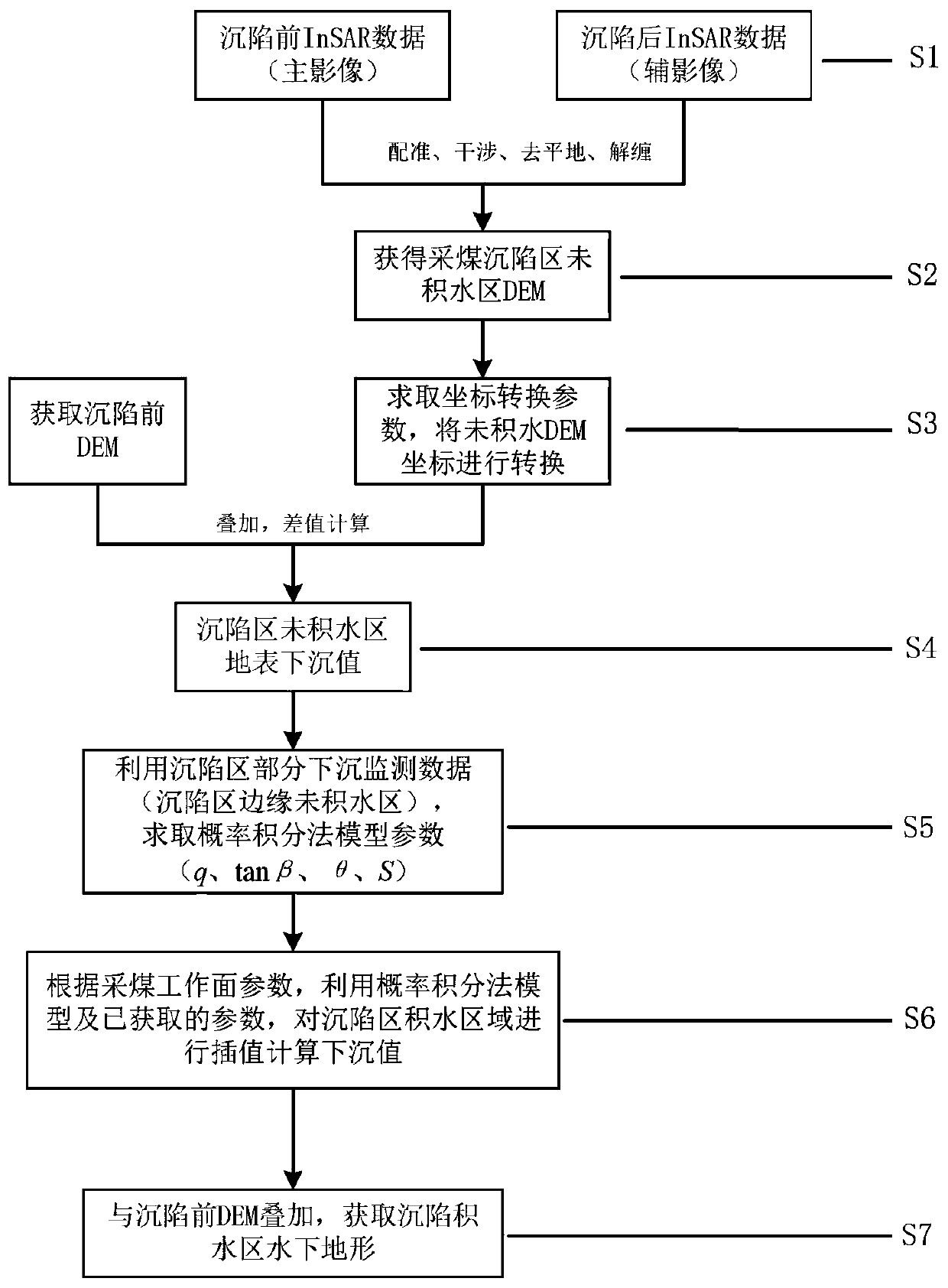
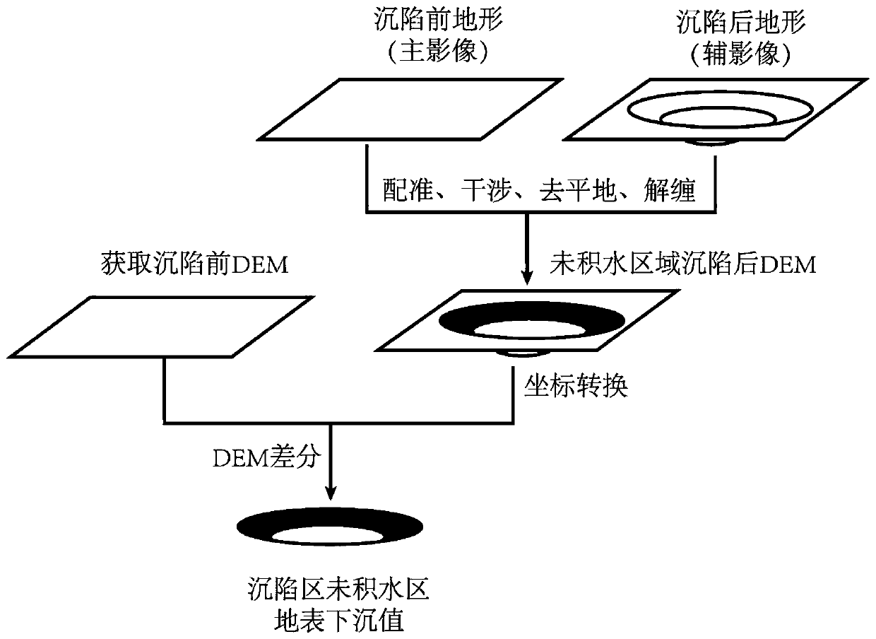
[0035] see Figure 1-2 As shown, this embodiment is a method for inversion of underwater terrain in coal mining subsidence water accumulation area using InSAR monitoring data, including the following steps:

[0036] S1. Obtain two sets of InSAR data before and after the subsidence of the surface above the coal mining face, use the InSAR data before the subsidence as the main image, and the InSAR data after the subsidence as the auxiliary image, and use the InSAR processing technology to combine the two InSAR images Acquire the DEM of the unwatered area in the coal mining subsidence area through standardization, interference processing, flattening, and phase unwrapping, and use H 1 (x,y) 未积水 Indicates that (x,y) 未积水 is the coordinates of the point in the subsidence area without water accumulation, H 1 is the elevation of the post-subsidence point;

[0037] S2. Generate the DEM before the subsidence of the coal mining subsidence area; the generation method of the DEM before ...

Embodiment 2

[0052] see Figure 1-2 As shown, this embodiment is a method for inversion of underwater terrain in coal mining subsidence water accumulation area using InSAR monitoring data, including the following steps:

[0053] S1. Obtain two sets of InSAR data before and after the subsidence of the surface above the coal mining face, use the InSAR data before the subsidence as the main image, and the InSAR data after the subsidence as the auxiliary image, and use the InSAR processing technology to combine the two InSAR images Acquire the DEM of the unwatered area in the coal mining subsidence area through standardization, interference processing, flattening, and phase unwrapping, and use H 1 (x,y) 未积水 Indicates that (x,y) 未积水 is the coordinates of the point in the subsidence area without water accumulation, H 1 is the elevation of the post-subsidence point;

[0054] S2. Generate the pre-subsidence DEM of the coal mining subsidence area; the generation method of the DEM before the sub...


PUM


Abstract

The invention discloses an underwater terrain inversion method for coal mining subsidence ponding area by using InSAR monitoring data. The method comprises the steps: firstly obtaining SAR images before and after the subsidence of a research area and DEM data before the subsidence of the subsidence area, and obtaining surface subsidence information after subsidence through employing the D-InSAR technology; solving a probability integral method parameter of a working surface according to the surface subsidence information and parameters such as working surface angular point coordinates, miningthickness and inclination angle; and finally, inverting the dynamic change of the underwater topography of the subsidence area and the final form of the underwater topography after stopping mining byadopting a model based on a probability integral method. According to the method, the InSAR data acquisition cost is low; the surface subsidence data obtained by the D-InSAR technology is high in precision and large in data volume; the parameter inversion is based on semi-measured data, a parameter inversion result is suitable for the research area, the underwater topography of a ponding area in the mining process of a working face can be inversed, the establishment of an amphibious composite ecosystem of the subsidence area is guided, and an important reference is provided for land utilization planning, land reclamation, ecological restoration and the like of the land surface of the subsidence area.

Description

technical field [0001] The invention relates to the technical field of underwater terrain measurement in a coal mining subsidence water accumulation area, in particular to an underwater terrain inversion method in a coal mining subsidence water accumulation area using InSAR monitoring data. Background technique [0002] The Lianghuai area is an important coal base in my country. The underground phreatic level in this area is high, the loose layer is thick, and the subsidence coefficient is large. The mining of coal resources causes the surface to subside to form a basin. Coupled with the combined influence of atmospheric precipitation and groundwater recharge, A large area of ​​accumulated water formed in the subsidence basin, leading to serious soil erosion in the subsidence area, villages and cultivated land were submerged by the accumulation of water, and the original terrestrial ecosystem was transformed into a water-terrestrial complex ecosystem, which had a serious impac...

Claims


Application Information

Patent Timeline
Patent Type & Authority Applications(China)
IPC IPC(8): G01S13/89
CPCG01S13/89
Inventor 朱晓峻彭雪妮张鹏飞刘辉杨晓玉
Owner ANHUI UNIVERSITY
Why Eureka
Try Eureka