Two-dimensional and three-dimensional integrated GIS system based on live-action three-dimensional

A three-dimensional, real-scene technology, applied in the direction of structured data retrieval, image data processing, special data processing applications, etc., can solve the problems of difficult customization and expansion, expensive GIS software, inconvenient use of users, etc., and achieve interoperability and data synchronization Effect

Active Publication Date: 2020-06-12
NANJING NORTH OPTICAL ELECTRONICS
View PDF2 Cites 25 Cited by
  • Summary
  • Abstract
  • Description
  • Claims
  • Application Information

AI Technical Summary

Problems solved by technology

[0003] At present, there are some commercial GIS platforms on the market that can provide 3D engines. Representative manufacturers include Skyline, Esri, HyperMap, etc. Users can carry out secondary development based on these 3D engines, but there are mainly the following shortcomings: First, commercial GIS software is relatively expensive , the system platform is relatively large, which is not conducive to rapid deployment and rapid development; secondly, due to its underlying architecture design, commercial GIS software is not agile in updating iterations, resulting in a long development cycle; commercial GIS software is relatively strong in encapsulation. In terms of the expansion of the expansion function module, it is not easy to carry out customized expansion
In addition, some commercial 3D GIS products still use browser plug-ins to load and display 3D scenes, which cannot make good use of webGL technology, making it inconvenient for users to use

Method used


Image

  • Two-dimensional and three-dimensional integrated GIS system based on live-action three-dimensional
  • Two-dimensional and three-dimensional integrated GIS system based on live-action three-dimensional

Examples


Embodiment Construction

[0019] In order to make the objectives, technical solutions and advantages of the present invention clearer, the following further describes the present invention in detail with reference to the accompanying drawings and embodiments. It should be understood that the specific embodiments described herein are only used to explain the present invention, but not to limit the present invention.

[0020] The implementation of the present invention will be described in detail below in conjunction with specific embodiments.

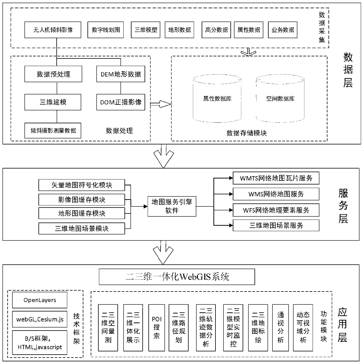
[0021] Such as figure 1 As shown, the present invention proposes a two- and three-dimensional integrated GIS system based on real scene three-dimensional, which is based on a three-tier architecture of data layer, service layer and application layer. By storing 3D models and 2D vectors, terrain and images from the bottom of the data in a completely unified database, providing complex SQL query, statistical analysis and other functions for data management; using the se...


PUM


Abstract

The invention discloses a two-dimensional and three-dimensional integrated GIS (Geographic Information System) based on live-action three-dimensional. The system comprises a data layer, a service layer and an application layer, the data layer comprises a data acquisition module, a data processing module and a data storage module; the data acquisition module comprises an unmanned aerial vehicle inclined image, a digital line map, a three-dimensional model, topographic data, high-resolution data, attribute data and business data; the service layer comprises a map rendering module and a map service publishing module; and the application layer comprises a two-dimensional and three-dimensional space measurement module, a two-dimensional and three-dimensional integrated display module, a POI search module, an intervisibility analysis module, a dynamic visual range analysis module, a two-dimensional and three-dimensional map plotting module, a two-dimensional and three-dimensional path planning module, a two-dimensional and three-dimensional trajectory data analysis module and a two-dimensional and three-dimensional model real-time monitoring module. According to the invention, the spatial analysis capability of the two-dimensional geographic information system and the display capability of the three-dimensional geographic information system are fused together, and the two-dimensionaland three-dimensional integrated linkage of the map data of the GIS framework is realized.

Description

Technical field [0001] The invention belongs to the technical field of information display and processing, and specifically relates to a two- and three-dimensional integrated GIS system based on real scene three-dimensional. Background technique [0002] With its unique intuitive visualization effects, 3D GIS has rapidly expanded to the fields of urban construction, military simulation, public security, fire protection, and smart transportation. However, because two-dimensional GIS is more abstract, macroscopic, comprehensive, easy to spatial analysis, and has been widely used in all walks of life in society, many units have built relatively complete two-dimensional geographic information and information management systems, so although three-dimensional GIS has two-dimensional GIS has incomparable advantages, but it cannot completely replace two-dimensional GIS for a long time. How to maximize the use of two-dimensional resources, integrate two-dimensional GIS and three-dimensio...

Claims


Application Information

Patent Timeline
Patent Type & Authority Applications(China)
IPC IPC(8): G06F16/29G06T17/05
CPCG06F16/29G06T17/05
Inventor 徐学永赵西亭刘梦楠王锦晨刘正凡陈炜灿施金金周叶王琛琛欧阳磊袁春琦张梦琪陆畅韩德鹏于大超
Owner NANJING NORTH OPTICAL ELECTRONICS
Why Eureka
Try Eureka