Ship driving route recommendation method and system

A recommended method and technology for ships, applied in traffic control systems, ship traffic control, navigation, etc., to achieve the effect of facilitating control and improving efficiency

Pending Publication Date: 2020-06-16
四川省交通勘察设计研究院有限公司 +1
View PDF2 Cites 4 Cited by
  • Summary
  • Abstract
  • Description
  • Claims
  • Application Information

AI Technical Summary

Problems solved by technology

[0004] The technical problem to be solved by the present invention is that the existing ship route recommendation method only relies on the meteorological information provided by the meteorological station and the water level information prompt a

Method used


Image

  • Ship driving route recommendation method and system
  • Ship driving route recommendation method and system
  • Ship driving route recommendation method and system

Examples


Embodiment 1

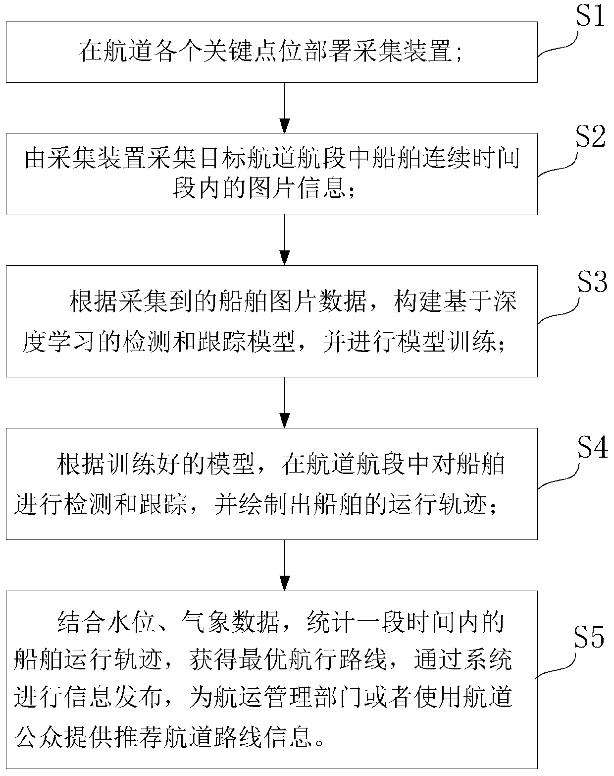
[0054] like Figure 1 to Figure 6 As shown, the present invention is a method for recommending shipping routes, which is implemented by taking the Sichuan inland high-grade waterway as an example. The method includes the following steps:

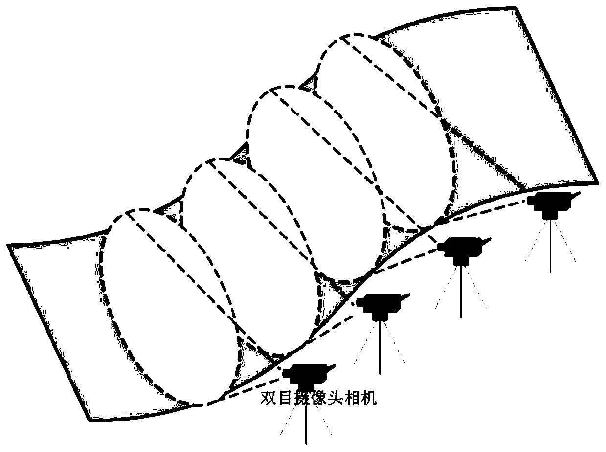
[0055] Step 1: Deploy acquisition devices at each key point of the channel, where: the acquisition device uses a binocular camera, and deploys a binocular camera within every 100-125m on one side of the channel, specifically as figure 2 It shows that each binocular camera deployed can cover the key waterway section, and the binocular camera has a wide field of vision and can cover the entire waterway cross section.

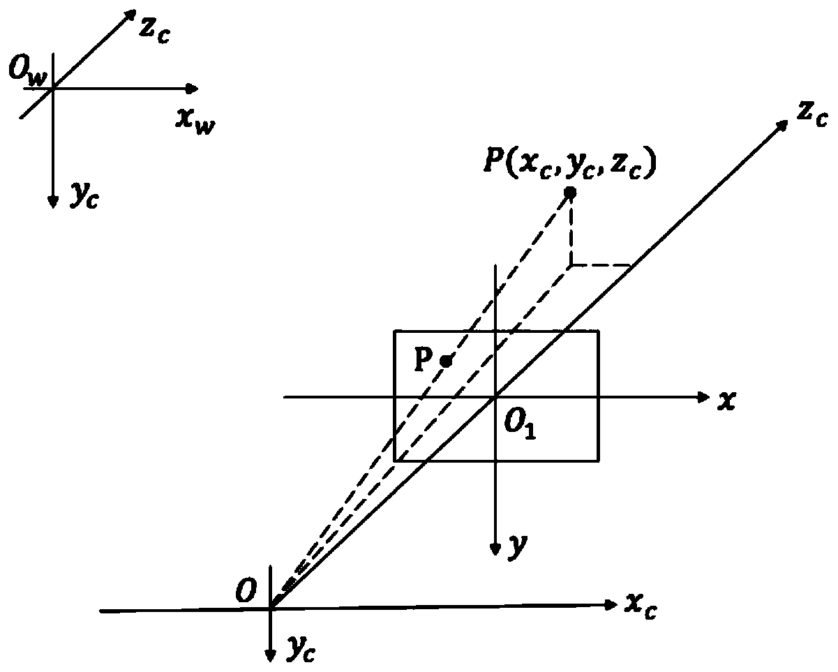
[0056] Step 2: Calibrate the binocular camera. The purpose of binocular camera calibration is to better locate the ship's trajectory in the waterway map. Calibration specifically includes:

[0057] Step 1: Carry out the corresponding conversion between the camera coordinate system of the binocular camera and the world coordin...

Embodiment 2

[0078] like Figure 1 to Figure 5 As shown, the difference between this embodiment and Embodiment 1 is that a system for recommending a shipping route, which supports a method for recommending a shipping route in Embodiment 1, such as Figure 5 As shown, the system includes a collection device, a processing module, a display terminal, a data center and a switch; on the display terminal, such as Image 6 As shown, on the interactive large screen, a three-dimensional channel map can be superimposed to display the recommended route.

[0079] The acquisition device deploys the acquisition device at each key point of the channel, and collects the picture information of the ship in the target channel segment in a continuous period of time; the acquisition device adopts a binocular camera, and is deployed within the scope of every 100-125m on one side of the channel a binocular camera;

[0080] The processing module constructs a detection and tracking model based on deep learning a...


PUM


Abstract

The invention discloses a ship driving route recommendation method and system. The method comprises the following steps: S1, deploying an acquisition device at each key point of a navigation channel;S2, a collection device collecting picture information of the ship in a continuous time period in the navigation segment of the target navigation channel; S3, constructing a detection and tracking model based on deep learning according to the acquired ship picture data, and performing model training; s4, according to the trained model, detecting and tracking the ship in the navigation channel segment, and drawing the moving track of the ship; and S5, in combination with the water level and meteorological data, performing statistics on the ship running track within a period of time to obtain anoptimal navigation route, and performing information release through the system to provide recommended navigation route information for shipping management departments or the public using navigationchannels. The system comprises an acquisition device, a processing module, a display terminal, a data center and a switch, and efficient ship route recommendation and monitoring are achieved.

Description

technical field [0001] The present invention relates to the technical field of ship shipping, in particular to a method and system for recommending a shipping route. Background technique [0002] At present, the existing methods to guide ships to navigate safely and avoid possible water transport risks are: (1) publicizing information to the public in combination with meteorological and water level information; Announcement to the public. However, the disadvantages of the existing above two methods are: [0003] 1. Only relying on the meteorological information provided by the meteorological station and the water level information prompt at the location of the water level gauge, it is difficult for the public to complete the ship trajectory estimation of the entire waterway; 2. Manual measurement has disadvantages such as not real-time, release lag, and incomplete information coverage. And currently there is no technical solution for route recommendation that can be displa...

Claims


Application Information

Patent Timeline
IPC IPC(8): G06T7/292G06T7/80G08G3/00G01C21/20G06F16/9535G06F16/9537
CPCG06T7/292G06T7/85G08G3/00G01C21/203G06F16/9537G06F16/9535G06T2207/10021G06T2207/20081G06T2207/20084G06T2207/30241G06T2207/30232
Inventor 张谧张有林李家世李顺超吴林谢地杨婷崔鸣邹芷桐胡阳王玲
Owner 四川省交通勘察设计研究院有限公司
Why Eureka
Try Eureka