Urban area function intelligent identification method based on multi-source data fusion

A technology for urban area and intelligent identification, applied in character and pattern recognition, structured data retrieval, geographic information database, etc.

Active Publication Date: 2020-07-07
XIAMEN UNIV
View PDF6 Cites 8 Cited by
  • Summary
  • Abstract
  • Description
  • Claims
  • Application Information

AI Technical Summary

Problems solved by technology

Building an interpretable urban computing system faces the unique challenge of large discrepancies between movement trajectory data and semantic text

Method used


Image

  • Urban area function intelligent identification method based on multi-source data fusion
  • Urban area function intelligent identification method based on multi-source data fusion
  • Urban area function intelligent identification method based on multi-source data fusion

Examples


Embodiment Construction

[0039] The present invention will be further described below through specific embodiments.

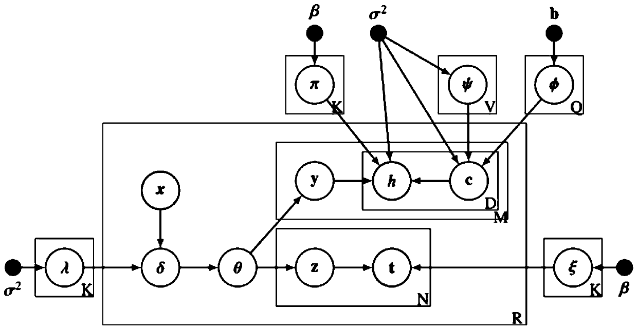
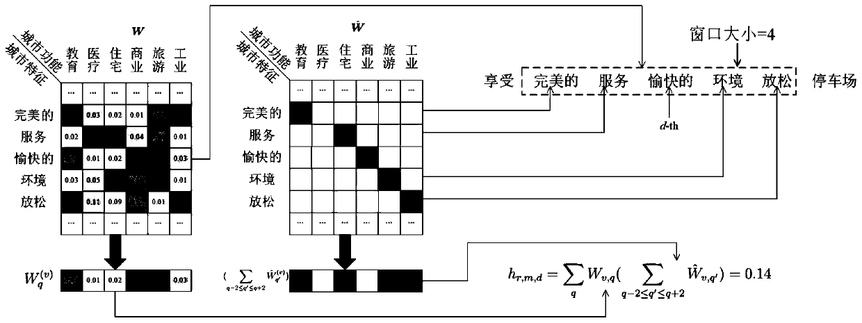
[0040] An intelligent identification method of urban regional functions based on multi-source data fusion of the present invention proposes an unsupervised clustering model EFRI based on a Bayesian hierarchical model to divide regional functions and add explanations. Such as figure 2 As shown, h, t, and x are the observable attributes of each region, that is, the input of the model. The output of the model includes the function distribution Θ of the region, the word vector Φ of the city function and the word vector Ψ of the city feature.

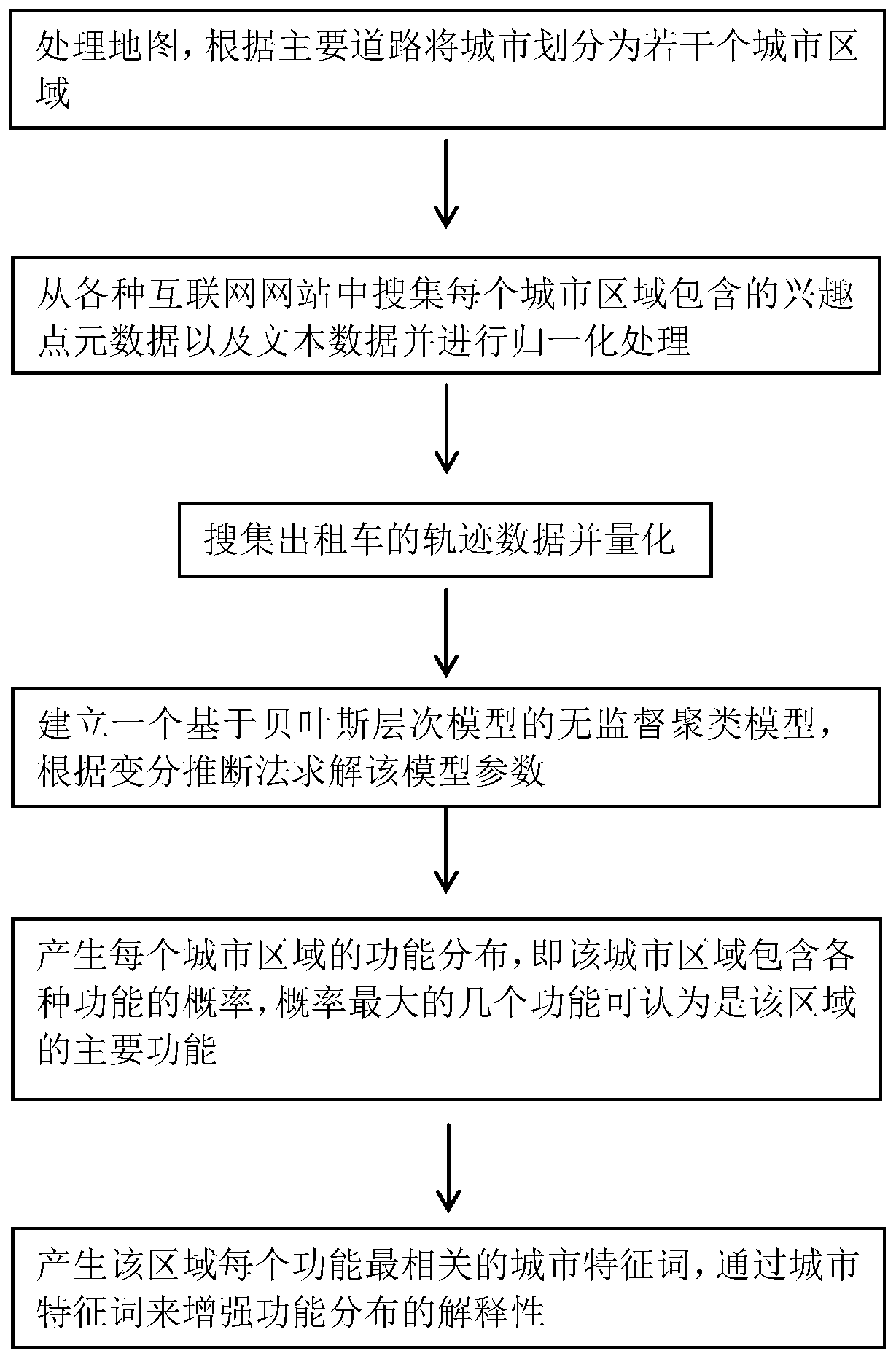
[0041] The data sets used in the experiment are obtained from various sources such as map software, taxi companies, large review and recommendation platforms, large social platforms, and real estate introduction agencies. figure 1 The flowchart of the urban area function identification method of the present invention, below in conjunction with fi...


PUM


Abstract

The invention discloses an urban area function intelligent identification method based on multi-source data fusion, and the method comprises the steps: obtaining the map data of a city, and dividing the city into a plurality of urban areas according to a main road; searching interest point metadata and text data contained in each city area from an Internet website and carrying out normalization processing; searching and quantifying the track data of the taxi; establishing an unsupervised clustering model based on a Bayesian hierarchical model, and solving model parameters according to a variational inference method; generating theme distribution of each urban area and correlation between each theme and various functions, and taking several urban functions most relevant to the theme with the maximum probability as main functions of the area; and generating the most relevant city feature words of each function in the region. According to the method, multi-source and multi-mode data are fused, urban area functions are intelligently recognized and divided, two explanation modes of function distribution and urban features are generated in a numerical value and text mode, and the reliability and the interpretability of urban area function recognition are enhanced.

Description

technical field [0001] The invention relates to the field of machine learning, in particular to a method for intelligently identifying urban area functions based on multi-source data fusion. Background technique [0002] Urban computing is a process of acquiring, integrating and analyzing big data and heterogeneous data generated from different sources in urban space. A critical step towards efficient urban computing is the identification of functional areas, which are areas of the city that support certain needs of urban functions. [0003] Most of the previous functional region identification (FRI) systems use clustering methods for human mobility data, including the analysis of telecommunication data, spectral cluster analysis, latent Dirichlet allocation (LDA) analysis, etc. However, the existing research has a serious flaw. Since the models studied in recent years are relatively complex and lack semantic interpretation for identifying regions, these clustering methods...

Claims


Application Information

Patent Timeline
IPC IPC(8): G06F16/29G06K9/62
CPCG06F16/29G06F18/23G06F18/24
Inventor 林琛翁宇游
Owner XIAMEN UNIV
Why Eureka
Try Eureka