

DSM automatic comparison system based on aerial photography measurement
An automatic comparison and comparison technology, which is applied in the field of aerial photography measurement, can solve the problems of many omissions, low efficiency, and high quality requirements of orthophoto images, so as to improve accuracy, improve comparison efficiency, improve efficiency and comparison accuracy Effect
- Summary
- Abstract
- Description
- Claims
- Application Information
AI Technical Summary
Problems solved by technology
Method used
Image

Examples
Embodiment
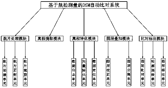
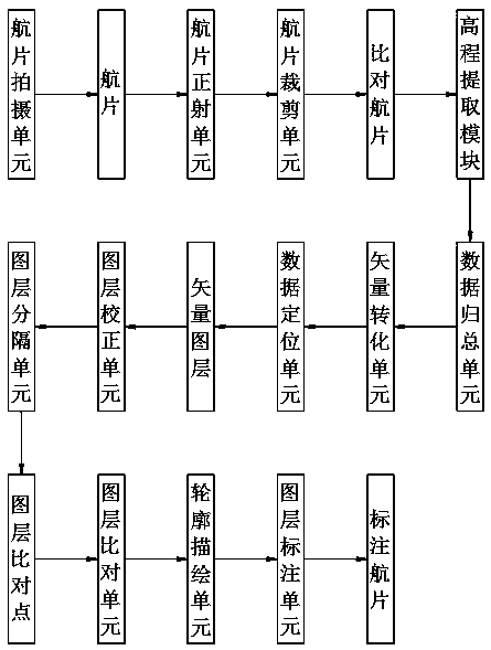
[0081] The elevation data extracted by the elevation extraction module is H to the extracted elevation data of the previous aerial photographs, and the elevation data extracted by the elevation extraction module to the current aerial photographs is I, and when the elevation conversion module converts the elevation data, the data The summarization unit sorts the elevation data in order, and sums up the data with the same elevation to form a collection of elevation data of previous aerial photos and the collection of current aerial photo elevation data , the vector conversion unit converts the collection of the elevation data of previous aerial photos into and the collection of current aerial photo elevation data Convert into vector data to form a vector data set of previous flight photos and the current aerial photo vector data set , the data location unit will vector Positioned on a layer with the same size as the clipped past air photos, the data positioning unit w...
PUM
 Abstract
Description
Claims
Application Information