
Rapid generation system and method for reconstructing abnormal road high-precision map based on space-time trajectory

A space-time trajectory generation system technology, applied in the traffic control system of road vehicles, traffic control system, structured data retrieval, etc., can solve the problems of not being able to give timely feedback on road emergencies, and not being able to quickly generate new traffic plans, etc. To achieve the effect of avoiding costs

Active Publication Date: 2020-07-10
河北德冠隆电子科技有限公司
View PDF5 Cites 21 Cited by
  • Summary
  • Abstract
  • Description
  • Claims
  • Application Information

AI Technical Summary

Problems solved by technology

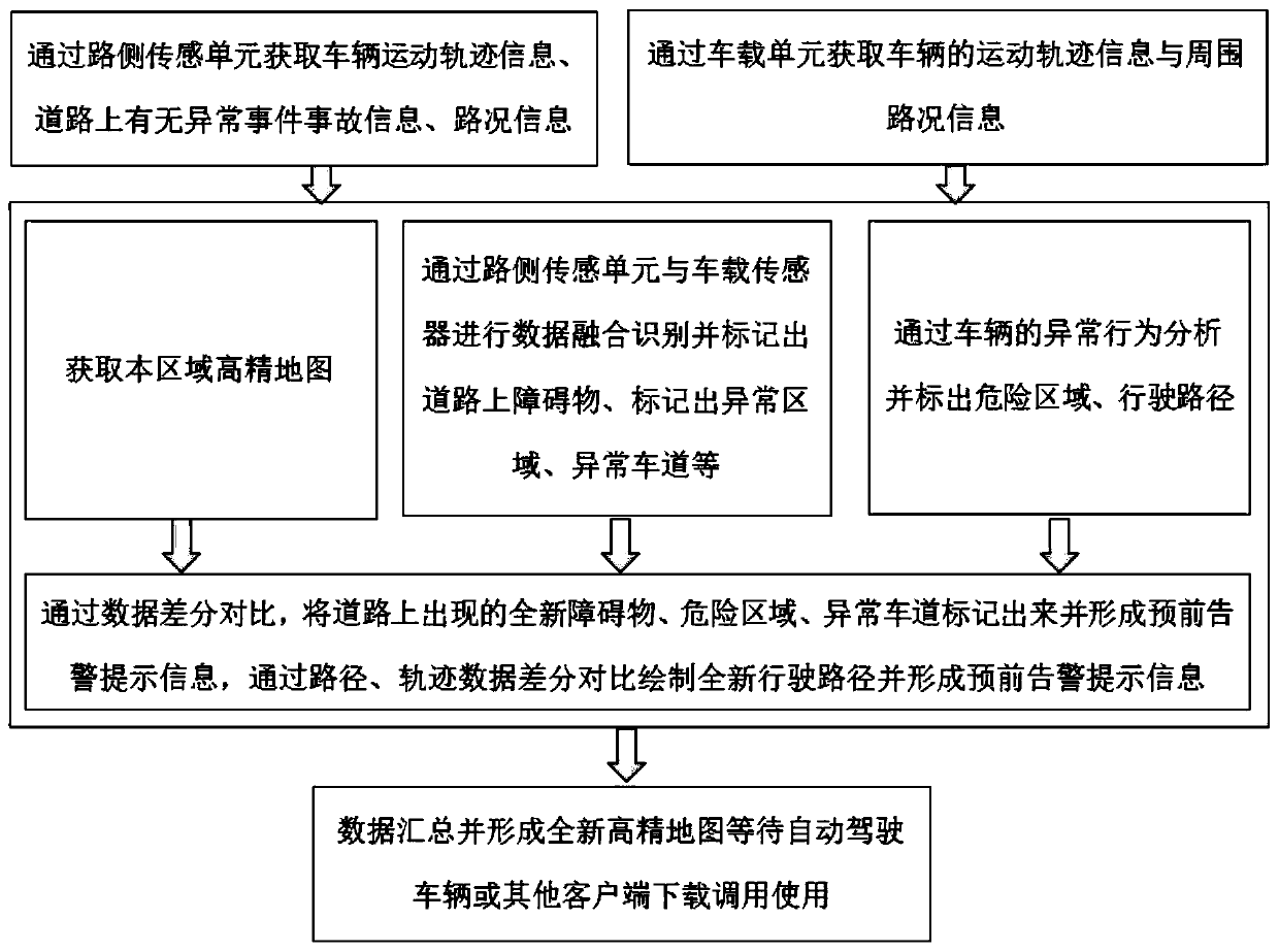
[0004] For this reason, the present invention provides a system and method for quickly generating high-precision maps of abnormal roads based on spatio-temporal trajectory reconstruction to solve the problems that existing maps cannot timely feed back road emergencies and cannot quickly generate new traffic plans

Method used


Image

  • Rapid generation system and method for reconstructing abnormal road high-precision map based on space-time trajectory
  • Rapid generation system and method for reconstructing abnormal road high-precision map based on space-time trajectory
  • Rapid generation system and method for reconstructing abnormal road high-precision map based on space-time trajectory

Examples


Embodiment 1

[0040] refer to figure 1 and figure 2 , this embodiment discloses a system for rapidly generating a high-precision map of abnormal roads based on spatio-temporal trajectory reconstruction, the system includes: a roadside sensing unit 1, a vehicle-mounted unit 2, and a big data service platform, and the roadside sensing unit 1 is set On the side of the road, the dynamic information, characteristic information, road condition information, traffic status information, climate information, and various abnormal event information of all types of vehicles driving on the road are collected in real time. The vehicle-mounted unit 2 is installed in unmanned vehicles, self-driving vehicles, artificially assisted driving vehicles, and road surveying and mapping vehicles. The vehicle-mounted unit 2 can dynamically and real-time obtain the location information of the vehicle, road condition information around itself, Environmental information, marking and marking information, event informat...

Embodiment 2

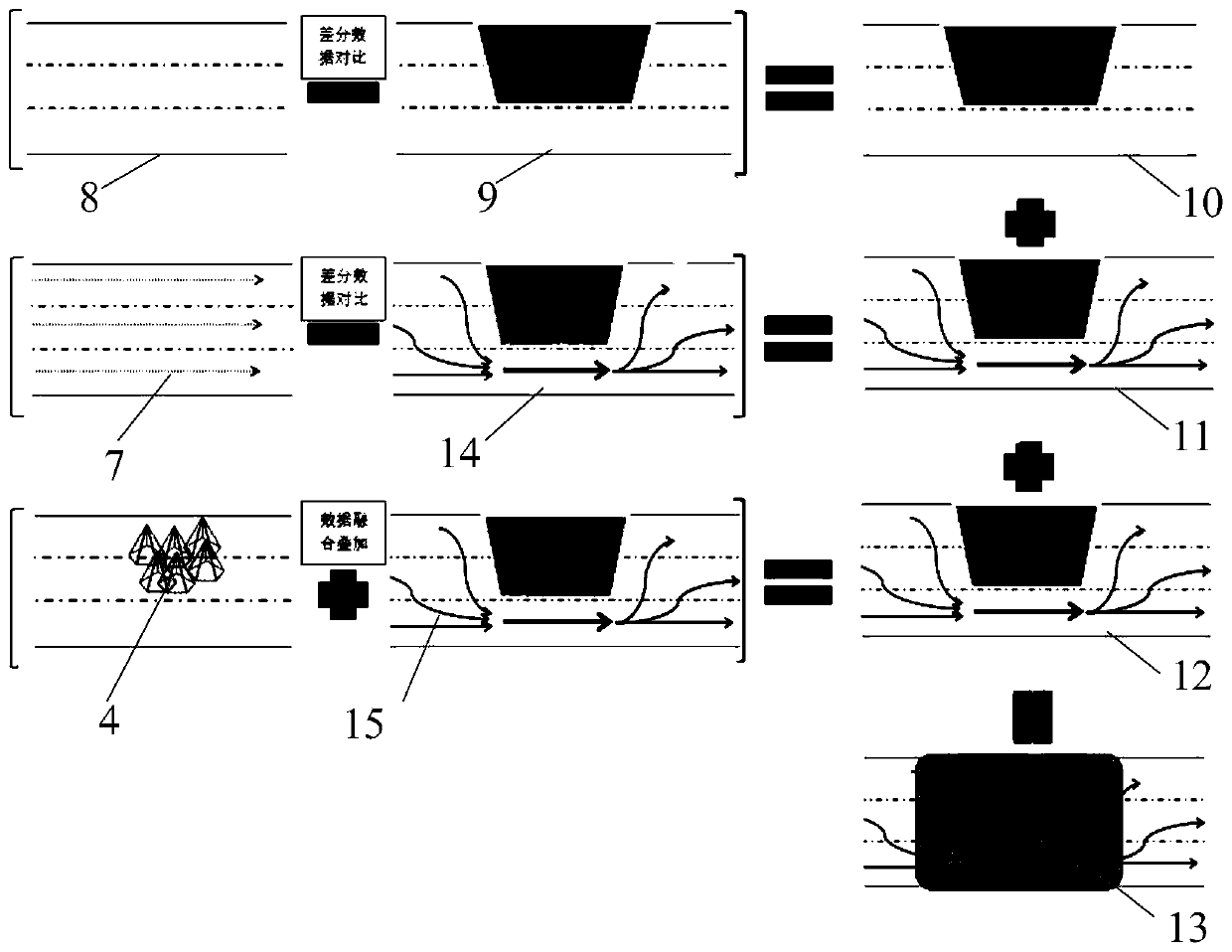
[0050] refer to image 3 , this embodiment discloses a method for quickly generating high-precision maps of abnormal roads based on spatio-temporal trajectory reconstruction. The difference data is compared with the reference regional road map 9 formed after preliminary fusion of similar data, and the differences are superimposed with the original high-precision map 8 of the road area to generate a new road base high-precision map 10. The system analyzes various types of data After processing, obtain the motion trajectories and running directions of all vehicles and convert them into lanes that allow normal vehicles to drive. The abnormal events obtained with the vehicle-mounted unit 2 are marked on the new road base high-precision map 10, and according to the type of the abnormal event 4 and the range, area, and lane affected, and combined with the principle of safe driving of the vehicle, the location of the abnormal event 4 is automatically generated. The center extends fo...


PUM


Abstract

The invention discloses a rapid generation system and method for reconstructing an abnormal road high-precision map based on a space-time trajectory. The system includes: a roadside sensing unit, a vehicle-mounted unit and a big data service platform. The roadside sensing unit acquires dynamic and characteristic information of a running vehicle and acquires road condition and traffic state information. The vehicle-mounted unit obtains track information of a vehicle and surrounding environment information. The collected data is transmitted to the big data service platform for reverse space-timetrajectory reconstruction; difference comparison is carried out on the reconstructed data and original high-precision map data of the region; and a difference is superposed with an original high-precision map to generate a brand-new road high-precision map, abnormal road information acquired by the roadside sensing unit and the vehicle-mounted unit are fused to the brand-new road high-precision map, and an abnormal position in the map is marked and thus can be called by a plurality of clients. According to the invention, the problems that the existing map cannot feed back the road emergency state in time and cannot quickly generate a new passing scheme are solved.

Description

technical field [0001] Embodiments of the present invention relate to space-time trajectory reconstruction, road side measurement, road survey, 3D model generation, map data generation, high-precision map drawing, automatic navigation, unmanned driving, automatic driving, automatic control, data transmission, road reconstruction, etc. A variety of fields, specifically related to a system and method for quickly generating high-precision maps of abnormal roads based on spatio-temporal trajectory reconstruction. Background technique [0002] The existing high-precision map is to collect road information in advance through road survey and measurement vehicles, and then draw a high-precision map. After the user loads the map and uses the positioning device to navigate, but when there is an unexpected situation on the road surface, dangerous pedestrians and animals invade , spilled objects, mudslides, road landslides, etc., when some lanes cannot pass normally, the original high-p...

Claims


Application Information

Patent Timeline
IPC IPC(8): G08G1/01G08G1/0967G08G1/0969G08G1/097G06F16/29
CPCG08G1/0116G08G1/0125G08G1/0137G08G1/096725G08G1/0969G08G1/097G06F16/29
Inventor 冯保国耿驰远付增辉郝永坡
Owner 河北德冠隆电子科技有限公司
Learn More