AUV multi-strategy navigation method based on submarine topography matching

A technology of terrain matching and navigation method, which is applied in the direction of navigation computing tools, sound wave reradiation, and measurement devices, etc., which can solve the problem of poor navigation ability in matching areas, inability to achieve high-precision underwater navigation, and unfavorable AUV task execution, etc. question

Active Publication Date: 2020-08-04
OCEAN UNIV OF CHINA
View PDF5 Cites 17 Cited by
  • Summary
  • Abstract
  • Description
  • Claims
  • Application Information

AI Technical Summary

Problems solved by technology

[0002] With the development of integrated navigation, when underwater vehicles sail on the seabed, due to the lack of GPS navigation, the method based on inertia/dead reckoning is generally adopted, and is equipped with expensive auxiliary equipment, such as attitude heading reference system or Doppler velocity recorder; however, due to the principle and characteristics of the inertial sensor itself, the inertial navigation system will generate cumulative errors over time, and cannot achieve long-term underwater high-precision navigation
At present, the main solution is to make the AUV float to receive GPS signals to correct the accumulated error, but this method is not conducive to the AUV's underwater task execution
[0003] As a geophysical navigation method, Terrain Adaptive Navigation (TAN) can provide accurate position estimation for AUV's long-range underwater operation. Three-dimens

Method used


Image

  • AUV multi-strategy navigation method based on submarine topography matching
  • AUV multi-strategy navigation method based on submarine topography matching
  • AUV multi-strategy navigation method based on submarine topography matching

Examples


Embodiment Construction

[0068] In order to understand the above-mentioned purpose, features and advantages of the present invention more clearly, the present invention will be further described below in conjunction with the accompanying drawings and embodiments. Many specific details are set forth in the following description to facilitate a full understanding of the present invention. However, the present invention can also be implemented in other ways than those described here. Therefore, the present invention is not limited to the specific embodiments disclosed below.

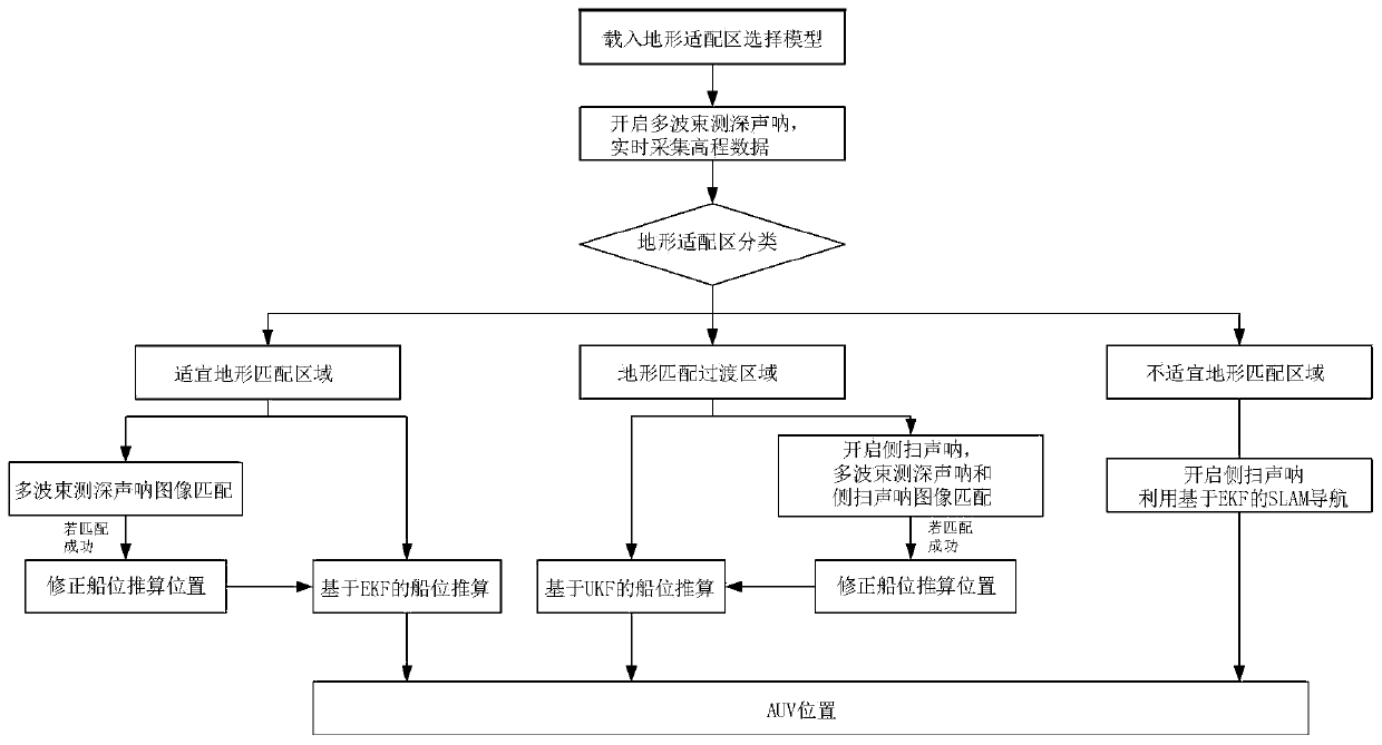
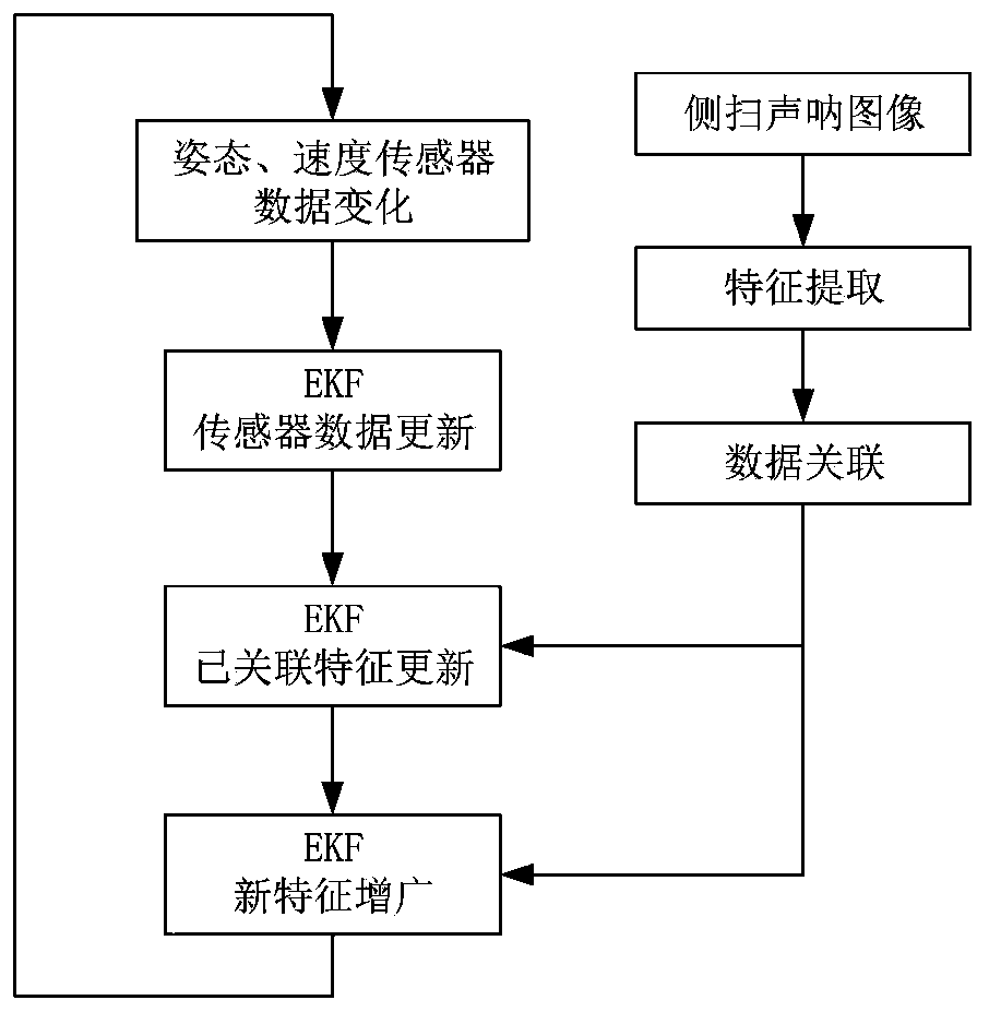
[0069] This embodiment proposes an AUV multi-strategy navigation method based on seabed terrain matching, such as figure 1 shown, including the following steps:

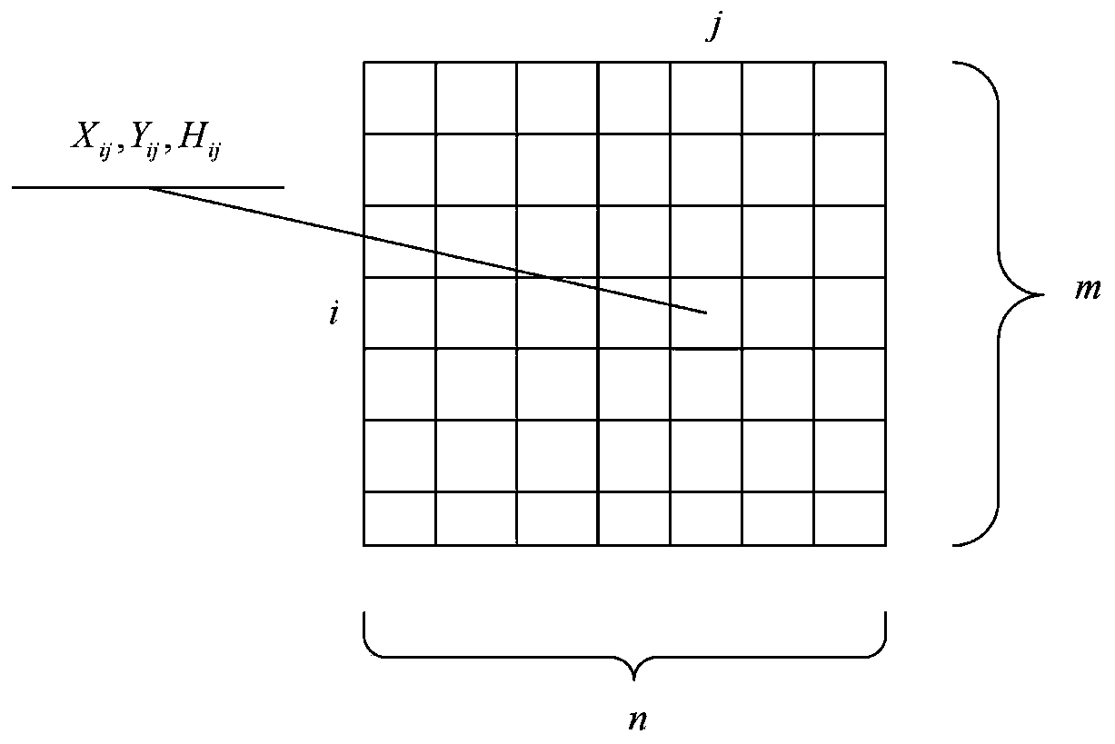
[0070] Step 1. Build a selection model for terrain adaptation areas. The classification of terrain adaptation areas includes suitable terrain matching areas, terrain matching transition areas, and unsuitable terrain matching areas;

[0071] Step 11, collect the model tra...


PUM


Abstract

The invention discloses an AUV multi-strategy navigation method based on submarine topography matching. The method comprises the steps: constructing a topography adaptive region selection model basedon a machine learning algorithm, wherein the topography adaptive region selection model includes a suitable topography matching region, a topography matching transition region, and an unsuitable topography matching region; during specific navigation, analyzing a type of a navigation area through collected real-time data, and carrying out navigation based on a multi-beam sonar underwater topographyelevation image matching auxiliary method for the suitable topography matching region; for the topography matching transition region, starting a side-scan sonar, and carrying out underwater side-scansonar image matching by using a multi-beam depth finder and the side-scan sonar data to assist ship position calculation for navigation; and for the unsuitable topography matching region, starting the side-scan sonar, and carrying out navigation based on simultaneous localization and a map construction algorithm. The navigation method has better significance and value in practical application.

Description

technical field [0001] The invention relates to the field of AUV autonomous navigation, in particular to an AUV multi-strategy navigation method based on seabed terrain matching. Background technique [0002] With the development of integrated navigation, when underwater vehicles sail on the seabed, due to the lack of GPS navigation, the method based on inertia / dead reckoning is generally adopted, and is equipped with expensive auxiliary equipment, such as attitude heading reference system or Doppler velocity Recorder; however, due to the principle and characteristics of the inertial sensor itself, the inertial navigation system will generate cumulative errors over time, and cannot achieve long-term underwater high-precision navigation. At present, the main solution is to make the AUV float up to receive GPS signals to correct the accumulated errors, but this method is not conducive to the AUV's underwater task execution. [0003] As a geophysical navigation method, Terrain...

Claims


Application Information

Patent Timeline
IPC IPC(8): G01C21/20G01S15/89
CPCG01C21/20G01S15/89G01S15/8902
Inventor 何波张昕严天宏沈钺年睿荣生辉冯晨李光亮
Owner OCEAN UNIV OF CHINA
Why Eureka
Try Eureka