Ultra-low-altitude flight area classification setting method for unmanned aerial vehicle

A low-altitude flight and area classification technology, applied to computer parts, instruments, character and pattern recognition, etc., can solve problems such as threats to national security and non-applicability

Active Publication Date: 2020-08-07
THE SECOND RES INST OF CIVIL AVIATION ADMINISTRATION OF CHINA
View PDF10 Cites 3 Cited by
  • Summary
  • Abstract
  • Description
  • Claims
  • Application Information

AI Technical Summary

Problems solved by technology

SORA has been used by the Civil Aviation Administration of China for the operational risk assessment of specific types of UAVs. However, if SORA is used for the risk assessment of the operating environment of UAVs in the grid based on the grid attributes of ultra-low altitude flight areas, SORA still exists. Certain limitations: On the one hand, drones are not only risky if they lose control spontaneously. If a drone in normal operation flies in an ultra-low-altitude flight area above a military base, it will also threaten national security and should be a risk event. In addition, If the UAV flies within the wake of a civil aviation transport aircraft, or flies between high-rise buildings, flight accidents may also occur due to the wake or high-rise wind, which also needs to be considered as a risk event; on the other hand, SORA At present, it is not suitable for the risk assessment of the mixed operation of UAVs and manned aircraft, but with the expansion of the application range of UAVs, it will surely realize the integrated operation of UAVs and manned aircrafts in the future, and the mixed operation of UAVs and manned aircrafts Risk assessment needs to be considered

Method used


Image

  • Ultra-low-altitude flight area classification setting method for unmanned aerial vehicle
  • Ultra-low-altitude flight area classification setting method for unmanned aerial vehicle
  • Ultra-low-altitude flight area classification setting method for unmanned aerial vehicle

Examples


Embodiment Construction

[0078] In order to make the object, technical solution and advantages of the present invention clearer, the present invention will be further described in detail below in conjunction with the accompanying drawings and embodiments. It should be understood that the specific embodiments described here are only used to explain the present invention, not to limit the present invention.

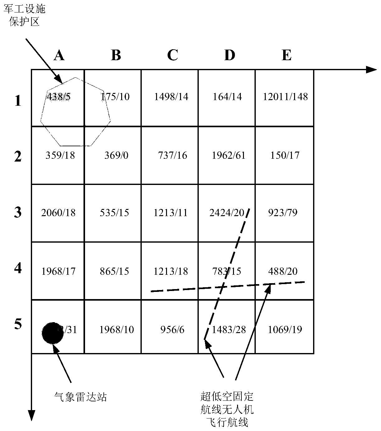
[0079] The ultra-low-altitude flight area below the true height of H meters is generally divided into a UAV flyable area and a control area. The UAV control area should have stronger restrictions on the operation of drones than the flyable area. Further, according to the actual operation needs, according to the risk of drones operating in the flyable area and control area from low to high, the drone flyable area and drone control area can be further subdivided into c 1 Subdivision type number and c 2 Subdivision types of UAV-like control area (c 1 ,c 2 ∈ N * ,c=c 1 +c 2 , that is, the number ...


PUM


Abstract

The invention discloses an ultra-low-altitude flight area classification setting method for an unmanned aerial vehicle, and the method comprises the following steps: carrying out the rasterization ofthe ultra-low-altitude flight area, and carrying out the unique identification of each grid; establishing unmanned aerial vehicle ultra-low-altitude flight area classification setting evaluation indexes and index quantitative calculation models to obtain n evaluation indexes and c risk level value intervals corresponding to the n evaluation indexes respectively; utilizing a G1 method to obtain each index weight; determining an adjacent grid addition characteristic value according to the risk evaluation index value interval corresponding to each grid; calculating the grade relative membership degree of the indexes corresponding to the grids; calculating to obtain an unmanned aerial vehicle flight limitation degree level characteristic value corresponding to the grid; and establishing an unmanned aerial vehicle flight limit degree level characteristic value threshold value model, comparing the unmanned aerial vehicle flight limit degree level characteristic value corresponding to the grid with the unmanned aerial vehicle flight limit degree level characteristic value threshold value, and determining an unmanned aerial vehicle ultra-low-altitude flight area classification division level number corresponding to the grid. The unmanned aerial vehicle ultra-low-altitude flight area classification setting method based on quantitative analysis is established by comprehensively considering three factors of the unmanned aerial vehicle over-the-ground risk, the over-the-air risk and the operation safety of the unmanned aerial vehicle.

Description

technical field [0001] The present invention relates to the technical field of air traffic control, in particular to unmanned aerial vehicle air traffic operation management. Background technique [0002] Unmanned aerial vehicles (hereinafter referred to as "UAVs") are aircraft managed by a control station (including remote control or autonomous flight), also known as remotely piloted aircraft. Due to the characteristics of good mobility, high survivability, and strong overload capacity, UAVs have broad application prospects in the fields of logistics transportation, power line inspection, agriculture, forestry and plant protection, emergency rescue and disaster relief, and geographic surveying and mapping. [0003] However, while the scale of the civilian drone market has been expanding in recent years, there are also many risks hidden in its operation: On April 30, 2017, a drone interfered with the flight of a civil airliner at Chengdu Shuangliu Airport, causing dozens of ...

Claims


Application Information

Patent Timeline
Patent Type & Authority Applications(China)
IPC IPC(8): G06F30/18G06Q10/06G06K9/62
CPCG06Q10/06393G06F18/24
Inventor 张建平吴卿刚邹翔谢方泉苏刚彭笑非
Owner THE SECOND RES INST OF CIVIL AVIATION ADMINISTRATION OF CHINA
Why Eureka
Try Eureka