Large-area ground surface coverage classification method based on multi-layer perceptual neural network

A multi-layer perception and neural network technology, applied in the field of automatic land cover classification method and system based on deep learning, can solve the problem of limited use, difficulty in effectively reflecting the spatio-temporal pattern and transformation rules of large-scale land cover, and inability to realize large-scale applications, etc. problem, to achieve the effect of strong generalization performance

Active Publication Date: 2020-09-01
CHANGGUANG SATELLITE TECH CO LTD
View PDF6 Cites 5 Cited by
  • Summary
  • Abstract
  • Description
  • Claims
  • Application Information

AI Technical Summary

Problems solved by technology

[0005] In order to solve the problems that the current land cover classification method is difficult to effectively reflect the spatio-temporal pattern and conversion rules of large-scale land cover, and cannot realize large-scale application, which leads to limited use, the present invention provides a large-area land cover classification based on multi-layer perceptual neural network method

Method used


Image

  • Large-area ground surface coverage classification method based on multi-layer perceptual neural network
  • Large-area ground surface coverage classification method based on multi-layer perceptual neural network
  • Large-area ground surface coverage classification method based on multi-layer perceptual neural network

Examples


specific Embodiment approach 1

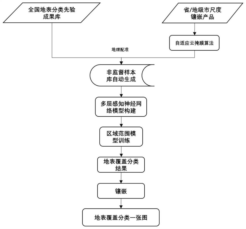
[0021] Specific implementation mode 1. Combination Figure 1 to Figure 5 Description of this embodiment, a method for classifying large-scale land cover based on a multi-layer perceptual neural network. First, use the 6S (Second Simulation of the Satellite Signal in the Solar Spectrum) model to perform surface albedo measurements on multi-remote sensing images of crop growth seasons. In order to avoid cloud interference, an adaptive Gaussian background modeling cloud mask method is proposed. Through the automatic geographic registration algorithm, the image to be classified is spatially corresponding to the image of the surface classification result set, and an unsupervised sample library automatic generation model is proposed to automatically generate the reflectance sample set. At the same time, the improved hyperplane outlier reflectance point removal model is used to remove outlier sample points with large differences in reflectance. The filtered sample points basically r...

specific Embodiment approach 2

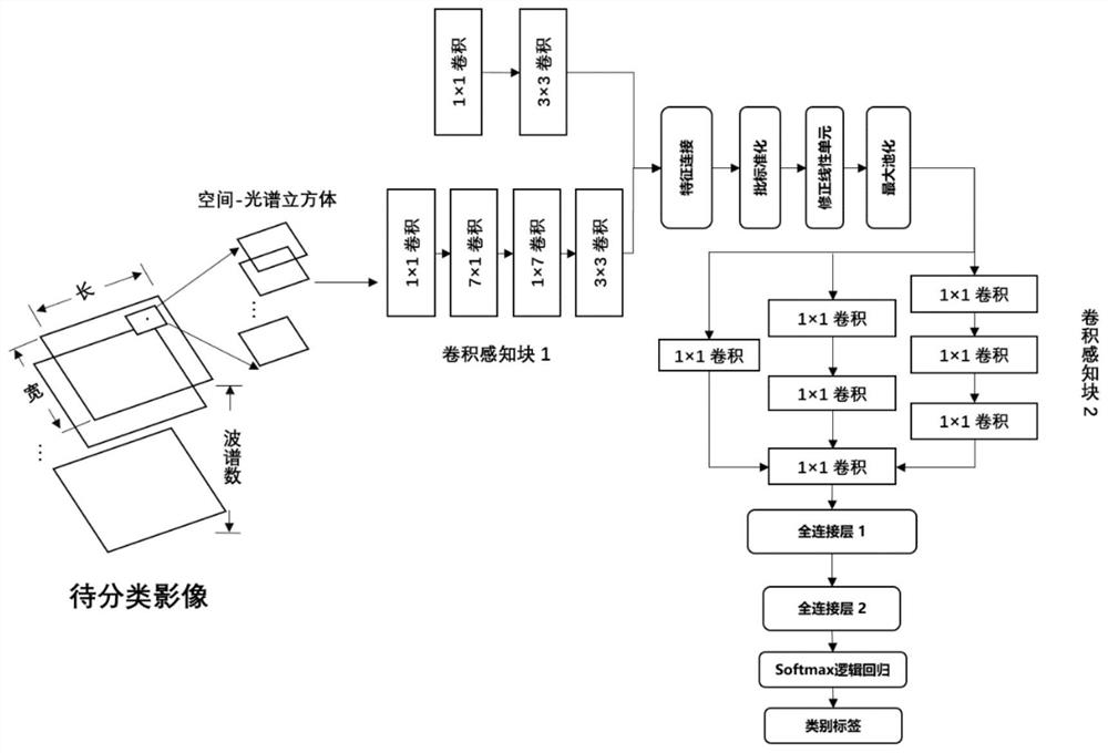
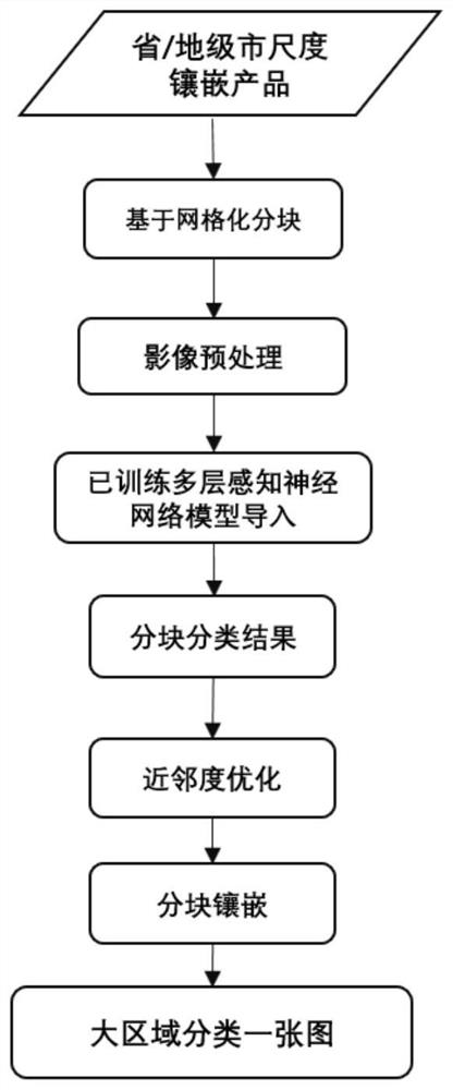
[0075] Specific embodiment two, in conjunction with Fig. 4 and Figure 5 This embodiment is described. This embodiment is an embodiment of a method for classifying large-area land cover based on a multi-layer perceptual neural network described in the first embodiment:


PUM


Abstract

The invention discloses a large-area ground surface coverage classification method based on a multi-layer perceptual neural network. The invention relates to the technical field of land surface remotesensing. The problem that an existing ground surface coverage classification method is difficult to effectively reflect the space-time pattern and the conversion rule of large-scale ground surface coverage, and use is limited due to the fact that large-scale application cannot be achieved are solved. The method comprises steps of performing ground surface reflectance calculation on the multiple remote sensing images, and performing spatial correspondence on the to-be-classified image and the surface classification result set image through a geographic automatic registration algorithm; and automatically generating a reflectance sample set through an unsupervised sample library; constructing a high-generalization space-spectral feature data training set suitable for a multi-layer perceptionalgorithm to complete model training; based on the trained multi-layer perceptual neural network model, interpreting the images in the scale range, and meanwhile, performing local optimization in combination with a semantic proximity optimization model to improve the miscellaneous property after classification. And a multi-GPU process block interpretation and inlaying mode is utilized to quicklycomplete land cover classification and inlaying of a graph.

Description

technical field [0001] The invention relates to the technical field of land surface remote sensing, in particular to a deep learning-based automatic land cover classification method and system. Background technique [0002] Global land cover data are a key source of information for understanding the complex interactions between human activities and global change, and are a variable in some key climate change studies (Imaoka et al. 2010). Land cover classification products can provide products for governments at all levels of natural resources supervision, land use type monitoring, planting structure monitoring, planting area statistics and other services. [0003] my country has entered a stage of rapid development of high-resolution earth observation technology. Continuous breakthroughs in domestic satellite hardware technology have led to increasing spatial resolution, temporal resolution, and even spectral resolution of remote sensing data, and the volume of remote sensin...

Claims


Application Information

Patent Timeline
Patent Type & Authority Applications(China)
IPC IPC(8): G06K9/00G06K9/62G06N3/04
CPCG06V20/188G06V20/13G06N3/047G06N3/045G06F18/24147G06F18/2433G06F18/2415G06F18/214
Inventor 李竺强朱瑞飞马经宇王栋杜一博
Owner CHANGGUANG SATELLITE TECH CO LTD
Why Eureka
Try Eureka