Online path planning method for fixed-wing unmanned aerial vehicle takeoff section cut-in waypoint

A path planning and unmanned aerial vehicle technology, which is applied in the field of aircraft navigation, guidance and control, and can solve the problems of reducing the degree of autonomy of the aircraft and insufficient wing lift

Pending Publication Date: 2020-09-11
湖北航天飞行器研究所
View PDF7 Cites 9 Cited by
  • Summary
  • Abstract
  • Description
  • Claims
  • Application Information

AI Technical Summary

Problems solved by technology

At the same time, for fixed-wing unmanned aerial vehicles or vertical take-off and landing compound fixed-wing unmanned aerial vehicles, since each take-off position and the relative height position of the first waypoint are uncertain, the nose direction of simultaneous take-off and the preset first waypoint The expected flight direction of a flight waypoint cannot be fixed in advance every time. The traditional take-off strategy requires an experienced ground station operator to plan a reasonable take-off route strategy to guide the aircraft to take off from the three-dimensional position and direction. For the first waypoint, if the flight path of the aircraft cutting into the waypoint is manually planned before each takeoff, the degree of autonomy of the aircraft will be greatly reduced
[0004] During the take-off phase of the fixed-wing UAV, the climb angle of the aircraft will not be set too large. This is to prevent the aircraft from stalling if the pitch angle is too high. Stall will lead to insufficient wing lift and crash. This is how to plan the take-off phase. The height strategy is also a challenge

Method used


Image

  • Online path planning method for fixed-wing unmanned aerial vehicle takeoff section cut-in waypoint
  • Online path planning method for fixed-wing unmanned aerial vehicle takeoff section cut-in waypoint
  • Online path planning method for fixed-wing unmanned aerial vehicle takeoff section cut-in waypoint

Examples


Embodiment Construction

[0097] In order to make the object, technical solution and advantages of the present invention clearer, the present invention will be further described in detail below in conjunction with the accompanying drawings and specific embodiments. It should be understood that the specific embodiments described here are only used to explain the present invention, not to limit the present invention. In addition, the technical features involved in the various embodiments of the present invention described below can be combined with each other as long as they do not constitute a conflict with each other.

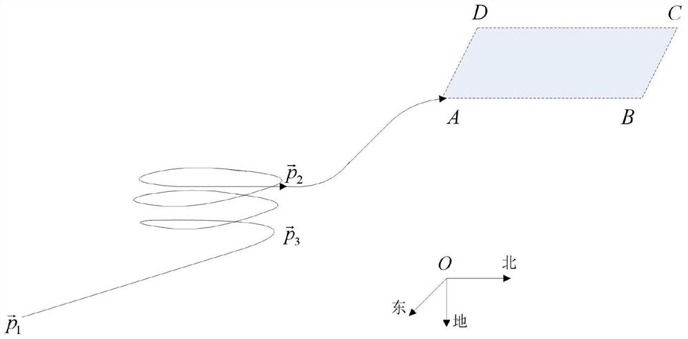
[0098] The relationship between the UAV body of the present invention, the expected flight waypoint, the proposed online planning path from the take-off section to the waypoint, and the three-dimensional north-east coordinate system is as follows: figure 1 shown. Specific steps are as follows:

[0099] The attitude angle information of the UAV relative to the ground inertial coordinat...


PUM


Abstract

The invention discloses an online path planning method for a fixed-wing unmanned aerial vehicle takeoff section cut-in waypoint. The method comprises: in the takeoff section, an unmanned aerial vehicle measuring the three-dimensional coordinate information of the flight attitude, speed and geographical position of the unmanned aerial vehicle through a navigation system device and a satellite receiver; comparing the information such as the three-dimensional position height and the flight speed direction of the aircraft with the information such as the three-dimensional position height and the expected flight speed direction of the expected first waypoint so as to plan climbing and turning paths; planning a feasible climbing path to the height of the first waypoint in the longitudinal direction; and planning a turning path meeting the expected direction of the first waypoint in the horizontal direction. Aimed at a take-off section of a fixed-wing unmanned aerial vehicle, the autonomous degree of the unmanned aerial vehicle is enhanced, the design is reasonable and feasible, the calculated amount is small, the flight path planning strategy of switching from the take-off point to the first waypoint is executed on line, the unmanned aerial vehicle can smoothly switch to the first preset waypoint in the height and flight direction, and the reliability and practicability of the systemare improved.

Description

technical field [0001] The invention belongs to the technical field of aircraft navigation, guidance and control, and in particular relates to an online path planning method for a fixed-wing unmanned aerial vehicle to cut into a waypoint during takeoff. Background technique [0002] UAVs have the advantages of small size, high mobility, effective reduction of driver casualties, and low life cycle costs. They can replace manned aircraft to perform various boring, dangerous, and harsh tasks, such as remote monitoring, Military fields such as reconnaissance and combat, as well as civil fields such as aerial photography, plant protection, express transportation, disaster relief, and surveying and mapping, have broad military and civilian prospects. [0003] With the continuous development of informatization, automation, and intelligent technologies, UAV technology has also undergone great changes, and the requirements for the degree of autonomy of UAVs have continued to increase...

Claims


Application Information

Patent Timeline
Patent Type & Authority Applications(China)
IPC IPC(8): G05D1/10G05D1/08
CPCG05D1/101G05D1/0808
Inventor 张达张华君李康伟刘青黄晓龙邬华明李盛许铠通
Owner 湖北航天飞行器研究所
Why Eureka
Try Eureka