High-spatial-resolution remote sensing image scene classification method based on target enhancement
A high spatial resolution, remote sensing image technology, applied in the field of high spatial resolution remote sensing image scene classification based on target enhancement, can solve the problems of low classification accuracy of remote sensing image scene classification, low efficiency of manual classification methods, complex spatial distribution, etc. Achieve the effects of improving classification efficiency, accelerating convergence speed, and improving learning efficiency
- Summary
- Abstract
- Description
- Claims
- Application Information
AI Technical Summary
Problems solved by technology
Method used
Image
Examples
specific Embodiment approach 1
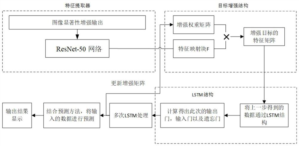
[0033] Specific implementation mode 1: Combination figure 1 This embodiment will be described. The method for classifying high spatial resolution remote sensing image scenes based on target enhancement described in this embodiment specifically includes the following steps:
[0034] Step 1: Collect a set of high spatial resolution remote sensing images X 1 (Generally, the resolution above 5m can be regarded as a high spatial resolution image), the high spatial resolution remote sensing image X 1 The label vector of the scene category contained in is Y;
[0035] Step two, to the collected high spatial resolution remote sensing image X 1 Gaussian filtering is performed on each image in respectively to obtain the Gaussian filtered image corresponding to each image;
[0036] Then convert each Gaussian filtered image into a Lab image (color space image). For any Lab image, calculate the average value of all pixels in the Lab image on each channel, and convert all pixels in the Lab image ...
specific Embodiment approach 2
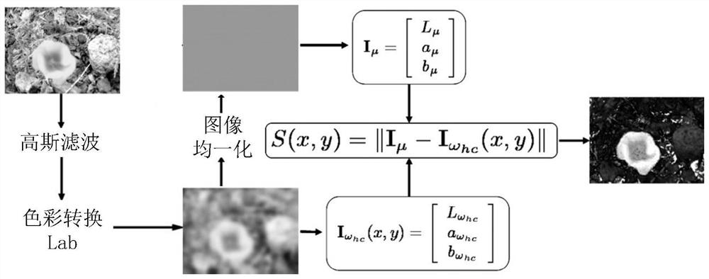
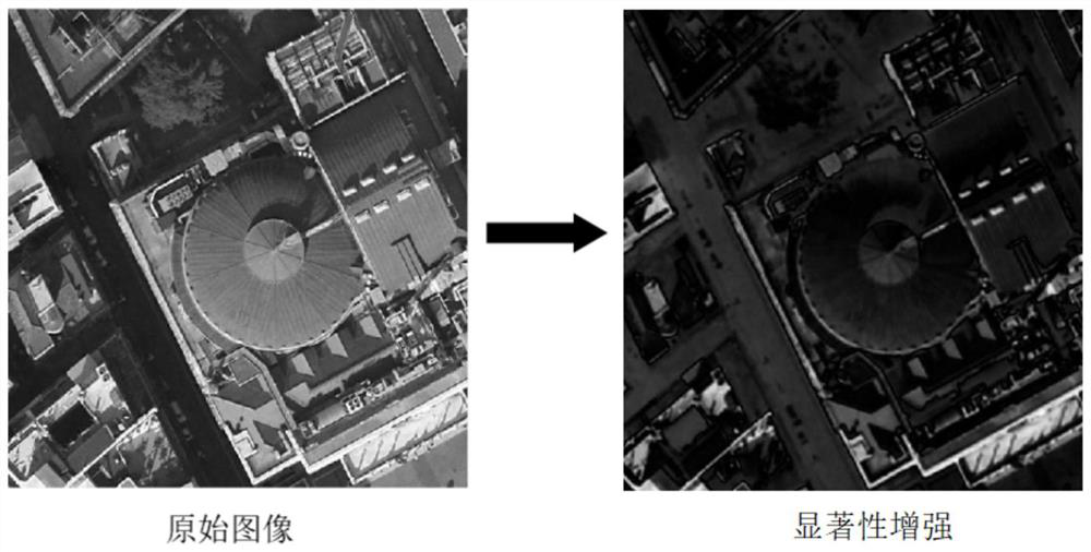
[0044] Specific implementation manner two: combination Figure 2a with Figure 2b This embodiment will be described. The difference between this embodiment and the first embodiment is that the specific process of the second step is:
[0045] Step Two: Respectively perform high spatial resolution remote sensing image X 1 Perform Gaussian filtering on each image in, to obtain an image after Gaussian filtering;
[0046] The high-frequency information in the image is removed from the image after Gaussian filtering, so that the image has more low-dimensional spatial information, that is, the image becomes smoother.
[0047] The image processed by Gaussian filtering is an RGB image, and each RGB image is converted into a corresponding Lab image. The conversion formula is as follows:
[0048]
[0049]
[0050]
[0051] In the formula, R, G, B are the elements of the RGB image on the three bands, L, a, b are the elements of the Lab image on the three channels, X, Y, Z, L', M'and S ′ Are inte...
specific Embodiment approach 3
[0066] Specific implementation mode three: combination Figure 3a This embodiment will be described. The difference between this embodiment and the second embodiment is that the specific process of the third step is:
[0067] Use the attention mask matrix as the attention weight, through the feature information block F and the initialized attention mask matrix a 1 Calculate the initial weight value x in the input long and short-term memory network (LSTM) 1 And an enhanced feature information block F 1 ;
[0068] Where the initialized attention mask matrix a 1 The value of is randomly generated;
[0069] The specific calculation formula is as follows:
[0070] a 1 ={a 1,1 ,a 1,2 ,...,A 1,P×P }
[0071]
[0072] f 1,j =a 1,j ×f j ,a 1,j A 1 ,f j ∈F,f 1,j ∈ F 1 ,j∈1,2,…,P×P
[0073] Where a 1 Is the initial attention mask matrix, a 1,j Is the jth element in the initial attention mask matrix, f 1,j Is an enhanced feature information block F 1 The jth element in x 1 It is the initial weight...
PUM
 Abstract
Description
Claims
Application Information
 - R&D
- Intellectual Property
- Life Sciences
- Materials
- Tech Scout
- Unparalleled Data Quality
- Higher Quality Content
- 60% Fewer Hallucinations
Browse by: Latest US Patents, China's latest patents, Technical Efficacy Thesaurus, Application Domain, Technology Topic, Popular Technical Reports.
© 2025 PatSnap. All rights reserved.Legal|Privacy policy|Modern Slavery Act Transparency Statement|Sitemap|About US| Contact US: help@patsnap.com


